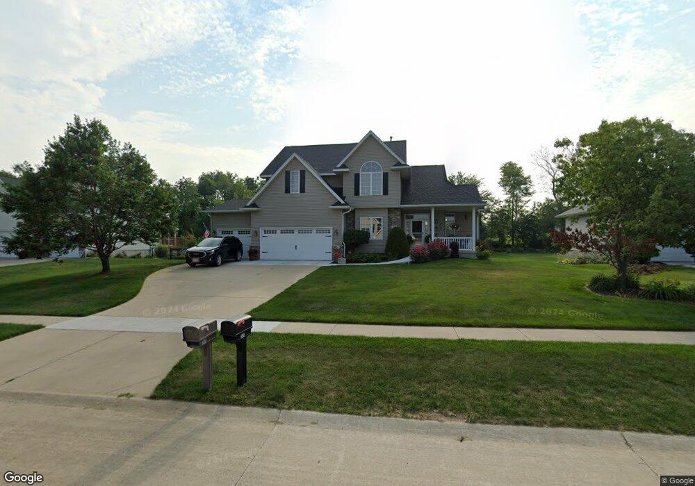
350 Brougham Rd Robins, IA 52328
Estimated Value: $395,172 - $440,000
4
Beds
5
Baths
2,256
Sq Ft
$189/Sq Ft
Est. Value
About This Home
This home is located at 350 Brougham Rd, Robins, IA 52328 and is currently estimated at $427,293, approximately $189 per square foot. 350 Brougham Rd is a home located in Linn County with nearby schools including Echo Hill Elementary School, Oak Ridge School, and Linn-Mar High School.
Ownership History
Date
Name
Owned For
Owner Type
Purchase Details
Closed on
Jun 14, 1999
Sold by
Odeen Charles S and Odeen Amy B
Bought by
Wiebel Terry J and Wiebel Renee A
Current Estimated Value
Purchase Details
Closed on
Jan 28, 1999
Sold by
Koski Melvin J and Koski Judith A
Bought by
Odean Charles S and Odean Amy B
Home Financials for this Owner
Home Financials are based on the most recent Mortgage that was taken out on this home.
Original Mortgage
$165,000
Interest Rate
6.75%
Purchase Details
Closed on
Jan 25, 1999
Sold by
Zeran Roger W
Bought by
Koski Melvin J and Koski Judith A
Home Financials for this Owner
Home Financials are based on the most recent Mortgage that was taken out on this home.
Original Mortgage
$165,000
Interest Rate
6.75%
Create a Home Valuation Report for This Property
The Home Valuation Report is an in-depth analysis detailing your home's value as well as a comparison with similar homes in the area
Home Values in the Area
Average Home Value in this Area
Purchase History
| Date | Buyer | Sale Price | Title Company |
|---|---|---|---|
| Wiebel Terry J | $226,500 | -- | |
| Odean Charles S | $33,000 | -- | |
| Koski Melvin J | -- | -- |
Source: Public Records
Mortgage History
| Date | Status | Borrower | Loan Amount |
|---|---|---|---|
| Previous Owner | Odean Charles S | $165,000 |
Source: Public Records
Tax History Compared to Growth
Tax History
| Year | Tax Paid | Tax Assessment Tax Assessment Total Assessment is a certain percentage of the fair market value that is determined by local assessors to be the total taxable value of land and additions on the property. | Land | Improvement |
|---|---|---|---|---|
| 2025 | $5,846 | $392,500 | $51,500 | $341,000 |
| 2024 | $5,596 | $390,200 | $51,500 | $338,700 |
| 2023 | $5,596 | $390,200 | $51,500 | $338,700 |
| 2022 | $5,808 | $338,000 | $51,500 | $286,500 |
| 2021 | $5,774 | $338,000 | $51,500 | $286,500 |
| 2020 | $5,774 | $314,000 | $51,500 | $262,500 |
| 2019 | $5,326 | $314,000 | $51,500 | $262,500 |
| 2018 | $5,132 | $291,000 | $51,500 | $239,500 |
| 2017 | $5,156 | $281,400 | $51,500 | $229,900 |
| 2016 | $5,156 | $281,400 | $51,500 | $229,900 |
| 2015 | $5,096 | $277,400 | $51,500 | $225,900 |
| 2014 | $4,936 | $277,400 | $51,500 | $225,900 |
| 2013 | $4,754 | $277,400 | $51,500 | $225,900 |
Source: Public Records
Map
Nearby Homes
- 0 Maple St
- 545 Evergreen Ln
- 9014 Grand Oaks Dr NE
- 9124 Grand Oaks Dr NE
- 8926 Norway Dr NE
- 8809 Middlebury Ct NE
- 8908 Norway Dr NE
- 1332 Stratton Dr NE
- 165 Timber Ln
- 70.78 Acres M L Quass Rd
- 923 Messina Dr NE
- 929 Messina Dr NE
- 8201 Council St NE
- 207 Meadows Field Dr NE
- 219 Meadows Field Dr NE
- 222 Mccarran Ave NE
- 226 Mccarran Ave NE
- 8901 Zeppelin Ave NE
- 8139 Turtlerun Dr NE
- 219 Mccarran Ave NE
- 370 Brougham Rd
- 330 Brougham Rd
- 440 Cypress Ct
- 390 Brougham Rd
- 312 Brougham Ct
- 445 Cypress Ct
- 355 Brougham Rd
- 335 Brougham Rd
- 375 Brougham Rd
- 400 Brougham Rd
- 325 Brougham Rd
- 445 Hickory Ct
- 385 Brougham Rd
- 450 Cypress Ct
- 314 Brougham Ct
- 395 Brougham Rd
- 455 Cypress Ct
- 410 Brougham Rd
- 455 Hickory Ct
- 315 Brougham Rd