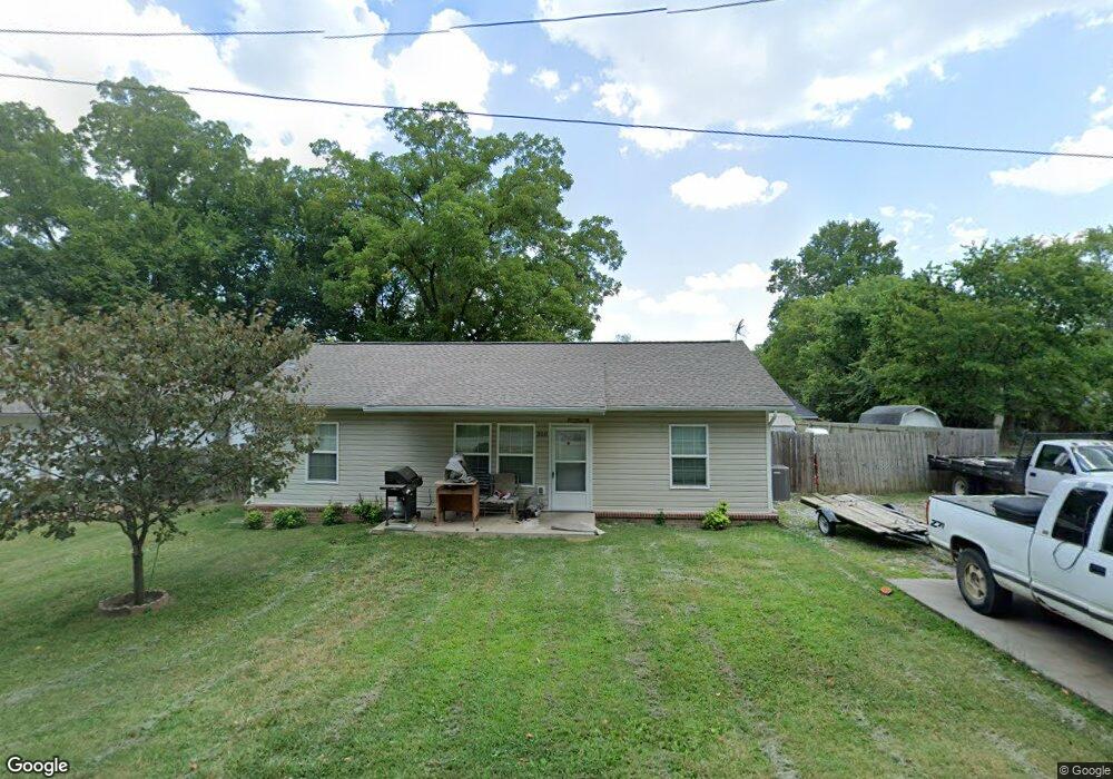
350 N B St Centerton, AR 72719
Estimated Value: $227,000 - $254,000
Studio
1
Bath
1,092
Sq Ft
$216/Sq Ft
Est. Value
About This Home
This home is located at 350 N B St, Centerton, AR 72719 and is currently estimated at $236,152, approximately $216 per square foot. 350 N B St is a home with nearby schools including Centerton Gamble Elementary School, Grimsley Junior High School, and Creekside Middle School.
Ownership History
Date
Name
Owned For
Owner Type
Purchase Details
Closed on
Dec 22, 2016
Sold by
Habitat For Humanity Of Benton Cnty Inc
Bought by
Blau Joshua J
Current Estimated Value
Home Financials for this Owner
Home Financials are based on the most recent Mortgage that was taken out on this home.
Original Mortgage
$111,000
Outstanding Balance
$83,848
Interest Rate
4.03%
Mortgage Type
New Conventional
Estimated Equity
$152,304
Purchase Details
Closed on
Mar 31, 2011
Sold by
Duncan Roger M
Bought by
Bank Of Gravett
Purchase Details
Closed on
Mar 6, 2010
Bought by
Dod 3 and Dod 6
Purchase Details
Closed on
Apr 20, 2004
Bought by
Duncan
Purchase Details
Closed on
Mar 17, 2004
Bought by
Dod 11 and Dod 17
Purchase Details
Closed on
May 16, 1975
Bought by
Threet
Create a Home Valuation Report for This Property
The Home Valuation Report is an in-depth analysis detailing your home's value as well as a comparison with similar homes in the area
Home Values in the Area
Average Home Value in this Area
Purchase History
| Date | Buyer | Sale Price | Title Company |
|---|---|---|---|
| Blau Joshua J | $111,000 | None Available | |
| Bank Of Gravett | $40,000 | None Available | |
| Dod 3 | -- | -- | |
| Duncan | $100,000 | -- | |
| Dod 11 | -- | -- | |
| Threet | -- | -- |
Source: Public Records
Mortgage History
| Date | Status | Borrower | Loan Amount |
|---|---|---|---|
| Open | Blau Joshua J | $111,000 |
Source: Public Records
Tax History
| Year | Tax Paid | Tax Assessment Tax Assessment Total Assessment is a certain percentage of the fair market value that is determined by local assessors to be the total taxable value of land and additions on the property. | Land | Improvement |
|---|---|---|---|---|
| 2025 | $1,250 | $43,689 | $17,000 | $26,689 |
| 2024 | $1,205 | $43,689 | $17,000 | $26,689 |
| 2023 | $1,148 | $28,320 | $7,000 | $21,320 |
| 2022 | $749 | $28,320 | $7,000 | $21,320 |
| 2021 | $689 | $28,320 | $7,000 | $21,320 |
| 2020 | $653 | $16,170 | $1,800 | $14,370 |
| 2019 | $653 | $16,170 | $1,800 | $14,370 |
| 2018 | $678 | $16,170 | $1,800 | $14,370 |
| 2017 | $111 | $16,170 | $1,800 | $14,370 |
| 2016 | $111 | $1,800 | $1,800 | $0 |
| 2015 | $123 | $2,000 | $2,000 | $0 |
| 2014 | $123 | $2,000 | $2,000 | $0 |
Source: Public Records
Map
Nearby Homes
- 195 N A St
- 392 N Main St
- 190 & 192 E 2nd St
- 940 Moksha St
- 930 Thornwood Place
- 940 Thornwood Place
- 920 Thornwood Place
- 1730 Greenbank Dr
- 101 Fox Run Cir
- 230 Fern St
- 2041 Tallgrass Terrace
- 571 Stoneseed St
- 2131 Periwinkle Place
- 471 Stoneseed St
- 561 Stoneseed St
- 1771 King Rd
- 269 Fern St
- 133 Fox Run Cir
- 350 Coopers Farm Rd
- 397 Thompson St
Your Personal Tour Guide
Ask me questions while you tour the home.