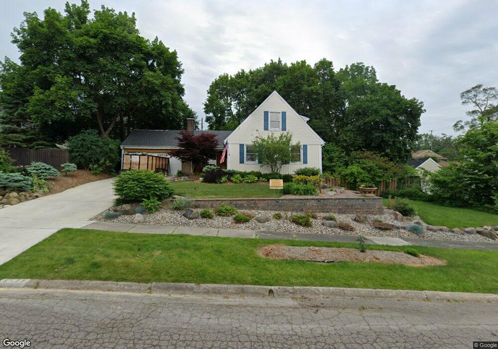
3501 Sherwood Dr Flint, MI 48503
Glendale NeighborhoodEstimated Value: $113,000 - $122,000
4
Beds
2
Baths
1,706
Sq Ft
$69/Sq Ft
Est. Value
About This Home
This home is located at 3501 Sherwood Dr, Flint, MI 48503 and is currently estimated at $117,754, approximately $69 per square foot. 3501 Sherwood Dr is a home located in Genesee County with nearby schools including Durant-Tuuri-Mott Elementary School, St. Paul Lutheran School, and St John Vianney Catholic School.
Ownership History
Date
Name
Owned For
Owner Type
Purchase Details
Closed on
May 25, 2023
Sold by
Alderman John D
Bought by
Alderman John D
Current Estimated Value
Purchase Details
Closed on
Sep 28, 2010
Sold by
Fannie Mae
Bought by
Alderman John D
Purchase Details
Closed on
Jun 28, 2010
Sold by
Bac Home Loans Servicing Lp
Bought by
Federal National Mortgage Association
Purchase Details
Closed on
Mar 24, 2010
Sold by
Decosta Glenn R and Desota Catherine A
Bought by
Bac Home Loans Servicing Lp
Purchase Details
Closed on
Dec 10, 2009
Sold by
Desota Catherine A and Desota Glenn R
Bought by
Desota Revocable Living Trust
Create a Home Valuation Report for This Property
The Home Valuation Report is an in-depth analysis detailing your home's value as well as a comparison with similar homes in the area
Home Values in the Area
Average Home Value in this Area
Purchase History
| Date | Buyer | Sale Price | Title Company |
|---|---|---|---|
| Alderman John D | -- | None Listed On Document | |
| Alderman John D | $40,249 | Attorneys Title Agency Llc | |
| Federal National Mortgage Association | -- | Attorneys Title Agency Llc | |
| Bac Home Loans Servicing Lp | $89,446 | None Available | |
| Desota Revocable Living Trust | -- | None Available |
Source: Public Records
Tax History Compared to Growth
Tax History
| Year | Tax Paid | Tax Assessment Tax Assessment Total Assessment is a certain percentage of the fair market value that is determined by local assessors to be the total taxable value of land and additions on the property. | Land | Improvement |
|---|---|---|---|---|
| 2025 | $1,714 | $62,200 | $0 | $0 |
| 2024 | $1,527 | $49,700 | $0 | $0 |
| 2023 | $1,485 | $45,100 | $0 | $0 |
| 2022 | $0 | $35,500 | $0 | $0 |
| 2021 | $1,561 | $36,200 | $0 | $0 |
| 2020 | $1,382 | $30,500 | $0 | $0 |
| 2019 | $1,751 | $23,100 | $0 | $0 |
| 2018 | $1,896 | $24,700 | $0 | $0 |
| 2017 | $1,840 | $0 | $0 | $0 |
| 2016 | $1,838 | $0 | $0 | $0 |
Source: Public Records
Map
Nearby Homes
- 3617 Sherwood Dr
- 3517 Norwood Dr
- 3119 Sherwood Dr
- 3414 Van Buren Ave
- 3705 Gratiot Ave
- 612 Bradley Ave
- 911 Hughes Ave
- 916 Mann Ave
- 2663 W Court St
- 932 Bradley Ave
- 2332 Nolen Dr
- 849 Frank St
- 2448 Thomas St
- 960 Mann Ave
- 2553 Thomas St
- 448 Dougherty Place
- 2539 Norbert St
- 976 Barney Ave
- 3821 W Court St
- 3921 Joyner St
- 3413 Sherwood Dr
- 3506 Brentwood Dr
- 3502 Brentwood Dr
- 3409 Sherwood Dr
- 3512 Brentwood Dr
- 419 Allendale Place Unit Bldg-Unit
- 419 Allendale Place
- 3422 Brentwood Dr
- 3405 Sherwood Dr
- 3515 Sherwood Dr
- 418 Allendale Place
- 417 Westcombe Ave
- 3410 Sherwood Dr
- 3401 Sherwood Dr
- 415 Allendale Place
- 3418 Brentwood Dr
- 410 Allendale Place
- 3404 Sherwood Dr
- 351 Westcombe Ave
- 3325 Sherwood Dr