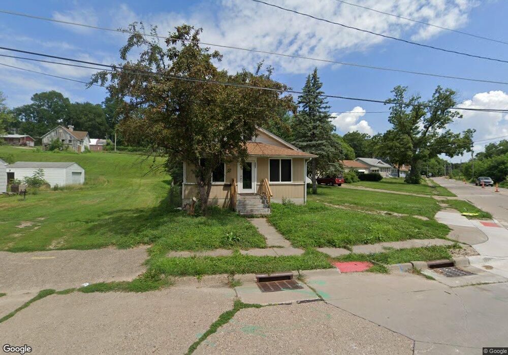
3502 May Ln Davenport, IA 52802
West End NeighborhoodEstimated Value: $79,000 - $106,000
2
Beds
1
Bath
835
Sq Ft
$115/Sq Ft
Est. Value
About This Home
This home is located at 3502 May Ln, Davenport, IA 52802 and is currently estimated at $95,812, approximately $114 per square foot. 3502 May Ln is a home located in Scott County with nearby schools including Hayes Elementary School, Frank L. Smart Intermediate School, and West High School.
Ownership History
Date
Name
Owned For
Owner Type
Purchase Details
Closed on
Feb 17, 2025
Sold by
Thompson Hunter G and Torrance Nannette M
Bought by
First Financial Group Lc
Current Estimated Value
Purchase Details
Closed on
Mar 22, 2024
Sold by
Thomspon Hunter G and Torrance Nannette M
Bought by
Thomspon Hunter G and Torrance Nannette M
Purchase Details
Closed on
Feb 13, 2024
Sold by
Scott County Mortgage
Bought by
Txbyr Series Llc and Torrance
Create a Home Valuation Report for This Property
The Home Valuation Report is an in-depth analysis detailing your home's value as well as a comparison with similar homes in the area
Home Values in the Area
Average Home Value in this Area
Purchase History
| Date | Buyer | Sale Price | Title Company |
|---|---|---|---|
| First Financial Group Lc | $75,000 | None Listed On Document | |
| Thomspon Hunter G | -- | None Listed On Document | |
| Txbyr Series Llc | -- | None Listed On Document |
Source: Public Records
Tax History Compared to Growth
Tax History
| Year | Tax Paid | Tax Assessment Tax Assessment Total Assessment is a certain percentage of the fair market value that is determined by local assessors to be the total taxable value of land and additions on the property. | Land | Improvement |
|---|---|---|---|---|
| 2025 | $1,370 | $92,930 | $13,820 | $79,110 |
| 2024 | $3,312 | $76,620 | $13,820 | $62,800 |
| 2023 | $2,750 | $89,670 | $13,820 | $75,850 |
| 2022 | $1,814 | $75,800 | $12,670 | $63,130 |
| 2021 | $1,434 | $75,800 | $12,670 | $63,130 |
| 2020 | $1,290 | $68,200 | $12,670 | $55,530 |
| 2019 | $1,274 | $65,280 | $12,670 | $52,610 |
| 2018 | $1,242 | $65,280 | $12,670 | $52,610 |
| 2017 | $363 | $65,280 | $12,670 | $52,610 |
| 2016 | $1,084 | $65,500 | $0 | $0 |
| 2015 | $1,084 | $66,040 | $0 | $0 |
| 2014 | $1,118 | $66,040 | $0 | $0 |
| 2013 | $940 | $0 | $0 | $0 |
| 2012 | -- | $62,860 | $11,760 | $51,100 |
Source: Public Records
Map
Nearby Homes
- 3216 Indian Rd
- 3154 Diehn Ave
- 3609 Boies Ave
- 3011 Telegraph Rd
- 3400 Telegraph Rd
- 815 S Dittmer St
- 3712 Johnson Ave
- 1023 S Elsie Ave
- 1018 S Concord St
- 1109 S Michigan Ave
- 2707 Jackson Ave
- 2736 Rockingham Rd
- 2614 Mckinley Ave
- 3631 Homestead Ave
- 3125 Pearl Ave
- 129 S Birchwood Ave
- 109 S Birchwood Ave
- 3412 Michigan
- 2502 Rockingham Rd
- 306 S Elmwood Ave