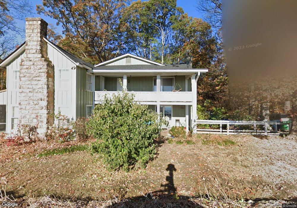
3503 E Brow Rd Signal Mountain, TN 37377
Walden NeighborhoodEstimated Value: $705,000 - $1,150,000
--
Bed
1
Bath
4,376
Sq Ft
$215/Sq Ft
Est. Value
About This Home
This home is located at 3503 E Brow Rd, Signal Mountain, TN 37377 and is currently estimated at $939,333, approximately $214 per square foot. 3503 E Brow Rd is a home located in Hamilton County with nearby schools including Nolan Elementary School, Signal Mountain Middle/High School, and Signal Mountain Christian School.
Ownership History
Date
Name
Owned For
Owner Type
Purchase Details
Closed on
Aug 1, 2019
Sold by
Laskowski Janet and Declaration Of Tr Of Mary Beat
Bought by
Laskowski Janet and Declaration Of Tr Of Mary Beat
Current Estimated Value
Purchase Details
Closed on
Aug 18, 2014
Sold by
Murphy Norma
Bought by
Kincer Kevin D and Kincer Sommer J
Purchase Details
Closed on
Sep 28, 2011
Sold by
Brown Henry Leo and Brown Mary Beatrice
Bought by
Brown Henry Leo and Henry Leo Brown Revocable Living Trust
Create a Home Valuation Report for This Property
The Home Valuation Report is an in-depth analysis detailing your home's value as well as a comparison with similar homes in the area
Home Values in the Area
Average Home Value in this Area
Purchase History
| Date | Buyer | Sale Price | Title Company |
|---|---|---|---|
| Laskowski Janet | -- | First Title | |
| Kincer Kevin D | $50,000 | Pioneer Title Agency Inc | |
| Brown Henry Leo | -- | None Available |
Source: Public Records
Tax History Compared to Growth
Tax History
| Year | Tax Paid | Tax Assessment Tax Assessment Total Assessment is a certain percentage of the fair market value that is determined by local assessors to be the total taxable value of land and additions on the property. | Land | Improvement |
|---|---|---|---|---|
| 2024 | $2,933 | $131,075 | $0 | $0 |
| 2023 | $3,629 | $131,075 | $0 | $0 |
| 2022 | $3,629 | $131,075 | $0 | $0 |
| 2021 | $3,629 | $131,075 | $0 | $0 |
| 2020 | $4,199 | $124,575 | $0 | $0 |
| 2019 | $4,074 | $124,575 | $0 | $0 |
| 2018 | $3,950 | $124,575 | $0 | $0 |
| 2017 | $3,925 | $124,575 | $0 | $0 |
| 2016 | $3,830 | $0 | $0 | $0 |
| 2015 | $3,830 | $119,900 | $0 | $0 |
| 2014 | $3,830 | $0 | $0 | $0 |
Source: Public Records
Map
Nearby Homes
- 3680 Wilson Ave
- 3002 Wilson Ave
- 914 Olsen Ave
- 2804 Taft Hwy
- 5517 Abby Grace Loop
- 810 Younger Cir
- 0 Browntown Rd Unit 1519397
- 60166014 Browntown Rd
- 5423 Mccahill Rd
- 311 Shady Crest Dr
- 3612 Taft Hwy
- 217 Lynnolen Ln
- 4975 Browntown Rd
- 848 Skyline Park Dr
- 6015 Sawyer Rd
- 1702 James Blvd
- 0 Skyline Park Dr Unit 1525124
- 2598 Bristlecone Ln
- 14 Lynnolen Ln
- 837 Skyline Park Dr
- 3509 E Brow Rd
- 3467 E Brow Rd
- 3511 E Brow Rd
- 3403 E Brow Rd
- 211 Lake Ave
- 3908 Ivory Ave
- 3609 E Brow Rd
- 3920 Ivory Ave
- 215 Lake Ave
- 4006 Ivory Ave
- 3906 Ivory Ave
- 4008 Ivory Ave
- 4012 Ivory Ave
- 219 Lake Ave
- 4402 Chestnut Ln
- 4016 Ivory Ave
- 3915 Ivory Ave
- 0 Chestnut Ave Unit 1209003
- 0 Chestnut Ave
- 3913 Ivory Ave