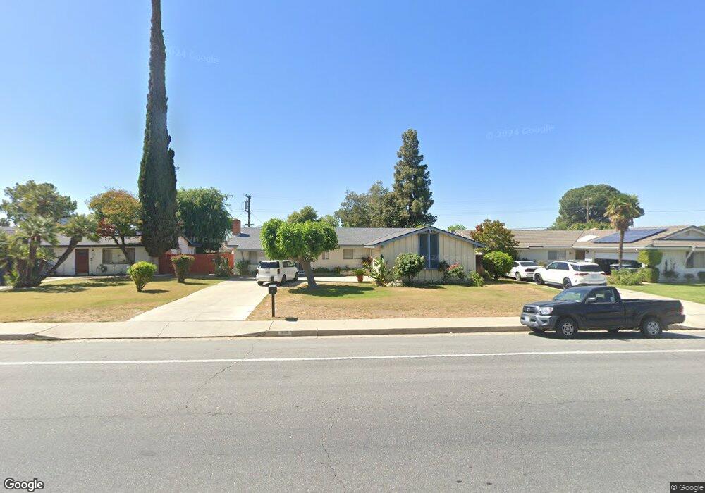
3507 University Ave Bakersfield, CA 93306
College Heights NeighborhoodEstimated Value: $310,000 - $341,000
4
Beds
2
Baths
1,532
Sq Ft
$212/Sq Ft
Est. Value
About This Home
This home is located at 3507 University Ave, Bakersfield, CA 93306 and is currently estimated at $324,489, approximately $211 per square foot. 3507 University Ave is a home located in Kern County with nearby schools including Colonel Howard Nichols Elementary School, Chipman Junior High School, and Highland High School.
Ownership History
Date
Name
Owned For
Owner Type
Purchase Details
Closed on
Mar 29, 2013
Sold by
Hubbell Bruce F and Hubbell Bonnie L
Bought by
Hubbell Bruce F and Hubbell Bonnie L
Current Estimated Value
Purchase Details
Closed on
Feb 24, 1997
Sold by
Mcginty Douglas E and Mcginty Janet D
Bought by
Hubbell Bruce F and Hubbell Bonnie L
Home Financials for this Owner
Home Financials are based on the most recent Mortgage that was taken out on this home.
Original Mortgage
$69,600
Interest Rate
7.66%
Create a Home Valuation Report for This Property
The Home Valuation Report is an in-depth analysis detailing your home's value as well as a comparison with similar homes in the area
Home Values in the Area
Average Home Value in this Area
Purchase History
| Date | Buyer | Sale Price | Title Company |
|---|---|---|---|
| Hubbell Bruce F | -- | None Available | |
| Hubbell Bruce F | $87,000 | First American Title Ins Co |
Source: Public Records
Mortgage History
| Date | Status | Borrower | Loan Amount |
|---|---|---|---|
| Previous Owner | Hubbell Bruce F | $69,600 |
Source: Public Records
Tax History Compared to Growth
Tax History
| Year | Tax Paid | Tax Assessment Tax Assessment Total Assessment is a certain percentage of the fair market value that is determined by local assessors to be the total taxable value of land and additions on the property. | Land | Improvement |
|---|---|---|---|---|
| 2025 | $2,259 | $141,684 | $40,710 | $100,974 |
| 2024 | $2,207 | $138,907 | $39,912 | $98,995 |
| 2023 | $2,207 | $136,184 | $39,130 | $97,054 |
| 2022 | $2,148 | $133,514 | $38,363 | $95,151 |
| 2021 | $2,041 | $130,897 | $37,611 | $93,286 |
| 2020 | $2,004 | $129,556 | $37,226 | $92,330 |
| 2019 | $1,963 | $129,556 | $37,226 | $92,330 |
| 2018 | $1,918 | $124,528 | $35,782 | $88,746 |
| 2017 | $1,905 | $122,087 | $35,081 | $87,006 |
| 2016 | $1,756 | $119,694 | $34,394 | $85,300 |
| 2015 | $1,742 | $117,897 | $33,878 | $84,019 |
| 2014 | $1,685 | $115,589 | $33,215 | $82,374 |
Source: Public Records
Map
Nearby Homes
- 3609 Cardinal Ave
- 3618 Redlands Dr
- 3221 Colgate Ln
- 3200 University Ave
- 3119 University Ave
- 4200 Columbus St
- 3206 Candlewood Dr
- 3818 Harvard Dr
- 4019 Columbus St
- 3712 Harvard Dr
- 3413 Redlands Dr
- 3800 Columbus St
- 3601 Harvard Dr
- 3706 Rampart St
- 3613 Fleetwood Way
- 2801 Kaibab Ave
- 2913 Harmony Dr
- 3019 Christmas Tree Ln
- 4205 Coronado Ave
- 2818 San Pablo Ave
- 3513 University Ave
- 3501 University Ave
- 3506 Kaibab Ave
- 3512 Kaibab Ave
- 3500 Kaibab Ave
- 3519 University Ave
- 3518 Kaibab Ave
- 3504 University Ave
- 3508 University Ave
- 3413 University Ave
- 3500 University Ave
- 3512 University Ave
- 3525 University Ave
- 3600 Kaibab Ave
- 3418 Kaibab Ave
- 3424 University Ave
- 3516 University Ave
- 3324 Colgate Ln
- 3331 Boise St
- 3520 University Ave