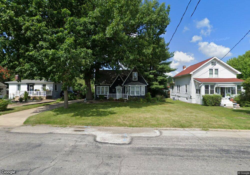
3509 N California Ave Peoria, IL 61603
West Bluff NeighborhoodEstimated Value: $99,000 - $122,000
3
Beds
1
Bath
1,156
Sq Ft
$100/Sq Ft
Est. Value
About This Home
This home is located at 3509 N California Ave, Peoria, IL 61603 and is currently estimated at $115,436, approximately $99 per square foot. 3509 N California Ave is a home located in Peoria County with nearby schools including Von Steuben Middle School, Peoria High School, and Peoria Christian School.
Ownership History
Date
Name
Owned For
Owner Type
Purchase Details
Closed on
Jun 3, 2024
Sold by
Anderson Joy M and Anderson Walter F
Bought by
Wernsman Jamie R
Current Estimated Value
Home Financials for this Owner
Home Financials are based on the most recent Mortgage that was taken out on this home.
Original Mortgage
$85,424
Outstanding Balance
$84,350
Interest Rate
7.1%
Mortgage Type
FHA
Estimated Equity
$31,086
Create a Home Valuation Report for This Property
The Home Valuation Report is an in-depth analysis detailing your home's value as well as a comparison with similar homes in the area
Home Values in the Area
Average Home Value in this Area
Purchase History
| Date | Buyer | Sale Price | Title Company |
|---|---|---|---|
| Wernsman Jamie R | $87,000 | None Listed On Document |
Source: Public Records
Mortgage History
| Date | Status | Borrower | Loan Amount |
|---|---|---|---|
| Open | Wernsman Jamie R | $85,424 |
Source: Public Records
Tax History Compared to Growth
Tax History
| Year | Tax Paid | Tax Assessment Tax Assessment Total Assessment is a certain percentage of the fair market value that is determined by local assessors to be the total taxable value of land and additions on the property. | Land | Improvement |
|---|---|---|---|---|
| 2024 | $3,525 | $38,970 | $4,990 | $33,980 |
| 2023 | $3,364 | $35,750 | $4,580 | $31,170 |
| 2022 | $3,217 | $33,350 | $4,430 | $28,920 |
| 2021 | $3,157 | $31,760 | $4,220 | $27,540 |
| 2020 | $3,151 | $31,450 | $4,180 | $27,270 |
| 2019 | $3,198 | $32,100 | $4,270 | $27,830 |
| 2018 | $3,133 | $32,170 | $4,320 | $27,850 |
| 2017 | $3,132 | $32,490 | $4,360 | $28,130 |
| 2016 | $1,937 | $32,490 | $4,360 | $28,130 |
| 2015 | $1,761 | $31,260 | $4,270 | $26,990 |
| 2014 | $1,774 | $30,130 | $4,050 | $26,080 |
| 2013 | -- | $30,500 | $4,100 | $26,400 |
Source: Public Records
Map
Nearby Homes
- 511 E Pasadena Ave
- 136 E Oak Park Dr
- 3206 N Indiana Ave
- 108 E Forrest Hill Ave
- 102 W Crestwood Dr
- 717 E Maywood Ave
- 516 E Maywood Ave
- 223 W Hollyridge Cir
- 904 E Forrest Hill Ave
- 4021 N Boulevard Ave
- 209 E Corrington Ave
- 915 E Elmhurst Ave
- 1000 E Forrest Hill Ave
- 3923 N Illinois Ave
- 2809 N California Ave
- 207 W Maywood Ave
- 2804 N Peoria Ave
- 1012 E Paris Ave
- 4012 N Boulevard Ave
- 401 W Forrest Hill Ave
- 3511 N California Ave
- 3505 N California Ave
- 3506 N Missouri Ave
- 3510 N Missouri Ave
- 3504 N Missouri Ave
- 3521 N California Ave
- 3502 N Missouri Ave
- 3425 N California Ave
- 3428 N Missouri Ave
- 313 E Embert Place
- 401 E Embert Place
- 3520 N Missouri Ave
- 3419 N California Ave
- 3422 N Missouri Ave
- 403 E Embert Place
- 405 E Embert Place
- 3420 N Missouri Ave
- 3524 N Missouri Ave
- 407 E Embert Place