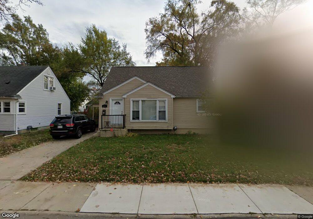
351 Adams Ct Ferndale, MI 48220
Estimated Value: $220,000 - $279,000
3
Beds
1
Bath
1,024
Sq Ft
$243/Sq Ft
Est. Value
About This Home
This home is located at 351 Adams Ct, Ferndale, MI 48220 and is currently estimated at $248,499, approximately $242 per square foot. 351 Adams Ct is a home located in Oakland County with nearby schools including Ferndale Lower Elementary Campus, Ferndale Upper Elementary Campus, and Ferndale Middle School.
Ownership History
Date
Name
Owned For
Owner Type
Purchase Details
Closed on
Jun 3, 2022
Sold by
Meisel Craig S
Bought by
Feinbaum Jake
Current Estimated Value
Home Financials for this Owner
Home Financials are based on the most recent Mortgage that was taken out on this home.
Original Mortgage
$240,560
Outstanding Balance
$227,521
Interest Rate
5.09%
Estimated Equity
$20,978
Purchase Details
Closed on
Jun 25, 2014
Sold by
Mertz Dennis K and Dennis K Mertz Living Trust
Bought by
Meisel Ventures Llc
Purchase Details
Closed on
Dec 27, 1999
Sold by
Mertz Maureen A
Bought by
Maureen A Mertz Tr
Purchase Details
Closed on
Dec 7, 1995
Sold by
Lester Sophia
Bought by
Mertz Maureen
Create a Home Valuation Report for This Property
The Home Valuation Report is an in-depth analysis detailing your home's value as well as a comparison with similar homes in the area
Home Values in the Area
Average Home Value in this Area
Purchase History
| Date | Buyer | Sale Price | Title Company |
|---|---|---|---|
| Feinbaum Jake | $248,000 | Devon Title Agency | |
| Meisel Ventures Llc | $106,250 | Fidelity Natl Title Ins Co | |
| Maureen A Mertz Tr | -- | -- | |
| Mertz Maureen | $52,500 | -- |
Source: Public Records
Mortgage History
| Date | Status | Borrower | Loan Amount |
|---|---|---|---|
| Open | Feinbaum Jake | $240,560 |
Source: Public Records
Tax History
| Year | Tax Paid | Tax Assessment Tax Assessment Total Assessment is a certain percentage of the fair market value that is determined by local assessors to be the total taxable value of land and additions on the property. | Land | Improvement |
|---|---|---|---|---|
| 2025 | $4,980 | $102,200 | $0 | $0 |
| 2024 | $4,779 | $100,150 | $0 | $0 |
| 2023 | $4,647 | $90,520 | $0 | $0 |
| 2022 | $2,828 | $84,180 | $0 | $0 |
| 2021 | $3,132 | $77,140 | $0 | $0 |
| 2020 | $2,700 | $66,720 | $0 | $0 |
| 2019 | $2,719 | $56,660 | $0 | $0 |
| 2018 | $3,009 | $48,390 | $0 | $0 |
| 2017 | $2,672 | $44,370 | $0 | $0 |
| 2016 | $2,638 | $37,760 | $0 | $0 |
| 2015 | -- | $33,420 | $0 | $0 |
| 2014 | -- | $29,000 | $0 | $0 |
| 2011 | -- | $45,550 | $0 | $0 |
Source: Public Records
Map
Nearby Homes
- 293 Fielding St
- 287 Fielding St
- 526 Saint Louis St
- 243 Edgewood Place
- 211 Silman St
- 457 W Bennett
- 274 Silman St
- 210 Saint Louis St
- 306 Silman St
- 207 Saint Louis St
- 918 Saint Louis St
- 202 W Bennett Ave
- 808 Laprairie St
- 2720 Woodstock Dr
- 366 E Marshall St
- 2564 Woodstock Dr
- 2548 Woodstock Dr
- 3127 W 8 Mile Rd
- 420 Silman St
- 2444 Woodstock Dr
Your Personal Tour Guide
Ask me questions while you tour the home.