
351 Main St Culloden, GA 31016
Estimated payment $2,461/month
Highlights
- Dining Room Seats More Than Twelve
- Fireplace in Primary Bedroom
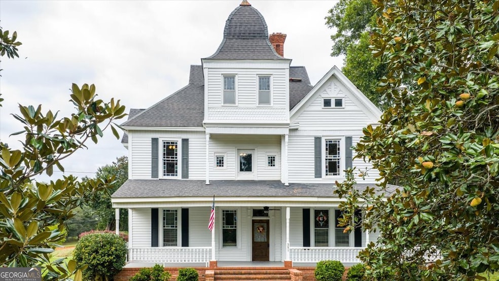
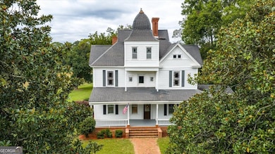
- Traditional Architecture
- Samuel E. Hubbard Elementary School Rated A-
- Seasonal View
- Wood Flooring
About This Home
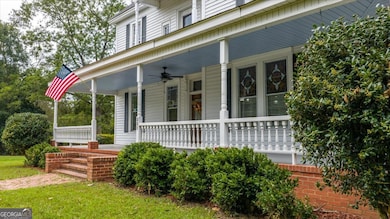
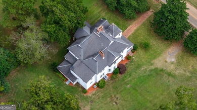
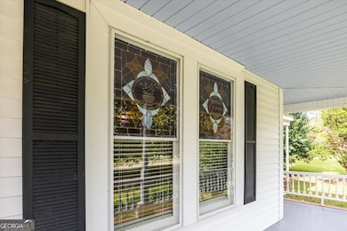
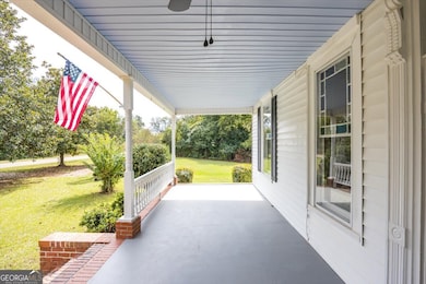
Step back in time and experience the charm of this beautifully preserved historic 1894 home located on Main Street in Culloden, Georgia. Sitting on just over an acre, this stunning 2-story masterpiece offers timeless elegance paired with thoughtful modern updates throughout. This spacious home features 7 bedrooms and 6 full bathrooms, providing endless opportunities for families, multi-generational living, or potential use as an Airbnb. Enjoy Southern living at its finest with a large wrap-around porch and a smaller covered side porch, perfect for relaxing. Inside, you'll find two grand foyers (one on each level), a formal living room with pocket doors and stained-glass windows, and a formal dining room with built-in cabinetry and bay windows. The home also showcases 7 original fireplace mantels and a sunroom overlooking the private backyard. The completely remodeled kitchen and butler's pantry include new cabinetry, granite countertops, a coffee bar, and stainless steel appliances-beautifully blending modern comfort with historic charm. With the amount of rooms this house has to offer, you can easily use a bedroom as a bonus room, or office. Built by Civil War veteran Joseph Oxford Holmes (1844-1922), this property originally operated as the Holmes Hotel until 1922 before becoming a cherished family home-remaining in the same family for approximately 131 years. This house has been preserved and maintained with central HVACs on two levels, city water, and a new septic system. Located next to the oldest brick Methodist church in Georgia and within walking distance to The Southern Cafe & Grill, this home sits in the heart of historic Culloden, established in the 1730s. It is part of Monroe County, known for its top-rated schools (#11 out of 178 districts in Georgia) and convenient access to Macon and Forsyth. This remarkable property offers the perfect blend of history, architecture, and opportunity-whether as a private residence or a profitable investment.
Home Details
Home Type
- Single Family
Est. Annual Taxes
- $2,028
Year Built
- Built in 1898
Lot Details
- 1.06 Acre Lot
- Level Lot
- Grass Covered Lot
Home Design
- Traditional Architecture
- Brick Exterior Construction
- Block Foundation
- Composition Roof
- Vinyl Siding
Interior Spaces
- 4,790 Sq Ft Home
- 2-Story Property
- Family Room with Fireplace
- 7 Fireplaces
- Living Room with Fireplace
- Dining Room Seats More Than Twelve
- Home Office
- Bonus Room
- Seasonal Views
- Crawl Space
Kitchen
- Breakfast Area or Nook
- Walk-In Pantry
- Oven or Range
- Microwave
- Dishwasher
- Stainless Steel Appliances
- Solid Surface Countertops
Flooring
- Wood
- Vinyl
Bedrooms and Bathrooms
- Fireplace in Primary Bedroom
Home Security
- Storm Windows
- Fire and Smoke Detector
Outdoor Features
- Patio
- Outbuilding
- Porch
Schools
- Hubbard Elementary School
- Monroe County Middle School
- Mary Persons High School
Utilities
- Cooling Available
- Propane
- Septic Tank
Community Details
- No Home Owners Association
- No Laundry Facilities
Listing and Financial Details
- Tax Lot 83
Map
Home Values in the Area
Average Home Value in this Area
Tax History
| Year | Tax Paid | Tax Assessment Tax Assessment Total Assessment is a certain percentage of the fair market value that is determined by local assessors to be the total taxable value of land and additions on the property. | Land | Improvement |
|---|---|---|---|---|
| 2024 | $1,776 | $75,080 | $6,320 | $68,760 |
| 2023 | $1,704 | $63,600 | $6,320 | $57,280 |
| 2022 | $1,397 | $63,600 | $6,320 | $57,280 |
| 2021 | $1,446 | $63,600 | $6,320 | $57,280 |
| 2020 | $1,483 | $63,600 | $6,320 | $57,280 |
| 2019 | $1,494 | $63,600 | $6,320 | $57,280 |
| 2018 | $1,499 | $63,600 | $6,320 | $57,280 |
| 2017 | $1,849 | $63,600 | $6,320 | $57,280 |
| 2016 | $1,426 | $63,600 | $6,320 | $57,280 |
| 2015 | $1,352 | $63,600 | $6,320 | $57,280 |
| 2014 | $1,305 | $63,600 | $6,320 | $57,280 |
Property History
| Date | Event | Price | List to Sale | Price per Sq Ft |
|---|---|---|---|---|
| 11/07/2025 11/07/25 | Price Changed | $435,000 | -3.3% | $91 / Sq Ft |
| 10/28/2025 10/28/25 | Price Changed | $449,999 | -10.0% | $94 / Sq Ft |
| 10/22/2025 10/22/25 | Price Changed | $499,999 | +5.5% | $104 / Sq Ft |
| 10/09/2025 10/09/25 | For Sale | $474,000 | -- | $99 / Sq Ft |
Purchase History
| Date | Type | Sale Price | Title Company |
|---|---|---|---|
| Warranty Deed | $130,000 | -- | |
| Warranty Deed | $9,000 | -- | |
| Warranty Deed | $9,000 | -- | |
| Warranty Deed | $9,000 | -- | |
| Warranty Deed | $9,000 | -- | |
| Deed | -- | -- | |
| Deed | -- | -- | |
| Deed | -- | -- |
Mortgage History
| Date | Status | Loan Amount | Loan Type |
|---|---|---|---|
| Open | $100,000 | New Conventional |
Source: Georgia MLS
MLS Number: 10622487
APN: 007B-058
Disclaimer: Certain information contained herein is derived from information provided by parties other than Homes.com. All information provided is deemed reliable, but is not guaranteed to be accurate and should be independently verified.
![]() The data relating to real estate for sale on this web site comes in part from the Broker Reciprocity Program of Georgia MLS. Real estate listings held by brokerage firms other than Redfin are marked with the Broker Reciprocity logo and detailed information about them includes the name of the listing brokers. Information deemed reliable but not guaranteed. Copyright 2025 Georgia MLS. All rights reserved.
The data relating to real estate for sale on this web site comes in part from the Broker Reciprocity Program of Georgia MLS. Real estate listings held by brokerage firms other than Redfin are marked with the Broker Reciprocity logo and detailed information about them includes the name of the listing brokers. Information deemed reliable but not guaranteed. Copyright 2025 Georgia MLS. All rights reserved.
- 674 Pine Grove Church Rd
- 6775 Ga Highway 42
- 500 Askin Place
- 0 Jordan Bottoms Rd Unit 25051630
- 1312 Edwards Rd
- 1338 Edwards Rd
- 0 Taylor Rd Unit 24629146
- 0 Taylor Rd Unit 24629140
- 0 Taylor Rd Unit 24629094
- 0 Pine Grove Church Rd Unit LOT 2 10525757
- 0 Pine Grove Church Rd Unit LOT 1 10525767
- 737 Pine Grove Church Rd
- 1787 Ramah Church Rd
- 305 Zellner Rd
- TRACT 2 U S 341
- 0 Ramah Church Rd Unit 10480661
- 0 Ramah Church Rd Unit 7542675
- 5588 Ga Highway 42 S Unit LOT 3
- 0 Kendall Dr Unit 10584739
- 168 Kerr Way
- 170 E Agency St
- 90 E Agency St
- 521 W Agency St
- 101 Owens Ln
- 314 W Gordon St Unit . 1
- 320 Veterans Dr
- 50 S Jackson St Unit 404
- 50 S Jackson St Unit 501
- 600 Holiday Cir
- 301 Barrington Hall Dr
- 4002 Holley Rd
- 1390 Royalwyn Dr
- 1149 Runnymede Ln
- 1356 Happy Trail
- 6435 Zebulon Rd
- 600 Lamar Rd
- 6300 Moseley Dixon Rd
- 399 Plantation Way
- 6229 Thomaston Rd
- 437 Kildare Way
