
Seller's Agent in 2025
Michael Packard
Coldwell Banker Community REALTORS®
(413) 586-8355
3 in this area
96 Total Sales

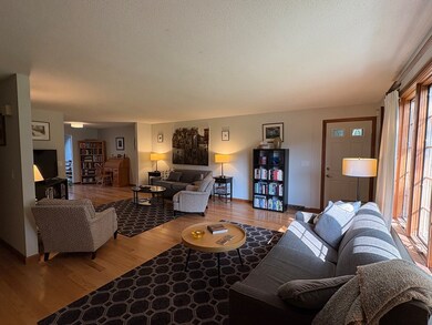
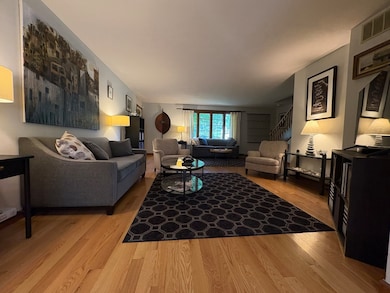
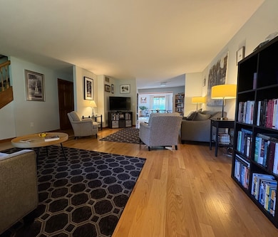
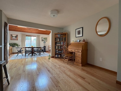

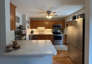
The large and open living space in this well maintained condominium has to be seen to be believed. Easily seats 28 for Thanksgiving dinner. 1716 square feet with two large bedrooms and two and a half baths. Hardwood and tile floors throughout the first floor. Newer stainless steel appliances in the kitchen. Two of the three bathrooms have been newly renovated. Both bedrooms have double closets. A full dry basement offers more room to expand and/or wonderful storage or workshop space. Natural gas heat and hot water, and central air conditioning for reasonable energy costs. A one car garage with room for storage, bikes, kayak, etc. A lovely patio and garden area. All of this in a well managed association in a convenient location in the vibrant city of Easthampton.
Last Agent to Sell the Property
Coldwell Banker Community REALTORS® Listed on: 06/11/2025
| Date | Type | Sale Price | Title Company |
|---|---|---|---|
| Deed | $375,000 | -- | |
| Deed | $375,000 | -- | |
| Quit Claim Deed | $214,000 | -- | |
| Quit Claim Deed | $214,000 | -- | |
| Deed | $215,000 | -- | |
| Deed | $215,000 | -- | |
| Deed | $215,000 | -- | |
| Deed | $200,000 | -- | |
| Deed | $200,000 | -- | |
| Deed | $200,000 | -- | |
| Deed | $224,000 | -- | |
| Deed | $224,000 | -- |
| Date | Status | Loan Amount | Loan Type |
|---|---|---|---|
| Previous Owner | $150,000 | No Value Available |
| Date | Event | Price | List to Sale | Price per Sq Ft |
|---|---|---|---|---|
| 08/26/2025 08/26/25 | Sold | $375,000 | 0.0% | $219 / Sq Ft |
| 06/18/2025 06/18/25 | Pending | -- | -- | -- |
| 06/11/2025 06/11/25 | For Sale | $375,000 | -- | $219 / Sq Ft |
| Year | Tax Paid | Tax Assessment Tax Assessment Total Assessment is a certain percentage of the fair market value that is determined by local assessors to be the total taxable value of land and additions on the property. | Land | Improvement |
|---|---|---|---|---|
| 2025 | $4,193 | $306,700 | $0 | $306,700 |
| 2024 | $4,369 | $322,200 | $0 | $322,200 |
| 2023 | $3,330 | $227,300 | $0 | $227,300 |
| 2022 | $3,757 | $227,300 | $0 | $227,300 |
| 2021 | $4,120 | $234,900 | $0 | $234,900 |
| 2020 | $4,037 | $227,300 | $0 | $227,300 |
| 2019 | $3,308 | $214,000 | $0 | $214,000 |
| 2018 | $3,272 | $204,500 | $0 | $204,500 |
| 2017 | $3,151 | $194,400 | $0 | $194,400 |
| 2016 | $3,031 | $194,400 | $0 | $194,400 |
| 2015 | $2,945 | $194,400 | $0 | $194,400 |
Seller's Agent in 2025
Michael Packard
Coldwell Banker Community REALTORS®
(413) 586-8355
3 in this area
96 Total Sales
Buyer's Agent in 2025
Erin Brunelle
Real Broker MA, LLC
(413) 250-8553
5 in this area
136 Total Sales
Source: MLS Property Information Network (MLS PIN)
MLS Number: 73389595
APN: EHAM-000155-000102-000007
Disclaimer: Certain information contained herein is derived from information provided by parties other than Homes.com. All information provided is deemed reliable, but is not guaranteed to be accurate and should be independently verified.
![]() The property listing data and information, or the Images, set forth herein were provided to MLS Property Information Network, Inc. from third party sources, including sellers, lessors and public records, and were compiled by MLS Property Information Network, Inc. The property listing data and information, and the Images, are for the personal, non-commercial use of consumers having a good faith interest in purchasing or leasing listed properties of the type displayed to them and may not be used for any purpose other than to identify prospective properties which such consumers may have a good faith interest in purchasing or leasing. MLS Property Information Network, Inc. and its subscribers disclaim any and all representations and warranties as to the accuracy of the property listing data and information, or as to the accuracy of any of the Images, set forth herein.
The property listing data and information, or the Images, set forth herein were provided to MLS Property Information Network, Inc. from third party sources, including sellers, lessors and public records, and were compiled by MLS Property Information Network, Inc. The property listing data and information, and the Images, are for the personal, non-commercial use of consumers having a good faith interest in purchasing or leasing listed properties of the type displayed to them and may not be used for any purpose other than to identify prospective properties which such consumers may have a good faith interest in purchasing or leasing. MLS Property Information Network, Inc. and its subscribers disclaim any and all representations and warranties as to the accuracy of the property listing data and information, or as to the accuracy of any of the Images, set forth herein.