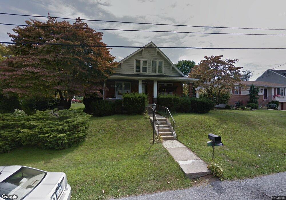
3510 W Union St Allentown, PA 18104
West End Allentown NeighborhoodEstimated Value: $349,796 - $380,000
4
Beds
1
Bath
1,920
Sq Ft
$189/Sq Ft
Est. Value
About This Home
This home is located at 3510 W Union St, Allentown, PA 18104 and is currently estimated at $363,199, approximately $189 per square foot. 3510 W Union St is a home located in Lehigh County with nearby schools including Highland Elementary School, Tussing Elementary School, and Cetronia Elementary School.
Ownership History
Date
Name
Owned For
Owner Type
Purchase Details
Closed on
Sep 30, 1996
Sold by
Molchany Mark M and Molchany Lorrie A
Bought by
Ganey Timothy L and Ganey Kimberly A
Current Estimated Value
Purchase Details
Closed on
Jun 4, 1996
Sold by
Rex Wilmer F and Rex Rachel A
Bought by
Molchany Mark M and Molchany Lorrie A
Purchase Details
Closed on
May 4, 1982
Sold by
Oswald Harry G Est
Bought by
Rex Wilmer F and Rex Rachel A
Create a Home Valuation Report for This Property
The Home Valuation Report is an in-depth analysis detailing your home's value as well as a comparison with similar homes in the area
Home Values in the Area
Average Home Value in this Area
Purchase History
| Date | Buyer | Sale Price | Title Company |
|---|---|---|---|
| Ganey Timothy L | $124,900 | -- | |
| Molchany Mark M | $74,000 | -- | |
| Rex Wilmer F | $30,000 | -- |
Source: Public Records
Tax History Compared to Growth
Tax History
| Year | Tax Paid | Tax Assessment Tax Assessment Total Assessment is a certain percentage of the fair market value that is determined by local assessors to be the total taxable value of land and additions on the property. | Land | Improvement |
|---|---|---|---|---|
| 2025 | $4,613 | $189,700 | $27,600 | $162,100 |
| 2024 | $4,458 | $189,700 | $27,600 | $162,100 |
| 2023 | $4,363 | $189,700 | $27,600 | $162,100 |
| 2022 | $4,346 | $189,700 | $162,100 | $27,600 |
| 2021 | $4,346 | $189,700 | $27,600 | $162,100 |
| 2020 | $4,346 | $189,700 | $27,600 | $162,100 |
| 2019 | $4,264 | $189,700 | $27,600 | $162,100 |
| 2018 | $4,124 | $189,700 | $27,600 | $162,100 |
| 2017 | $3,982 | $189,700 | $27,600 | $162,100 |
| 2016 | -- | $189,700 | $27,600 | $162,100 |
| 2015 | -- | $189,700 | $27,600 | $162,100 |
| 2014 | -- | $189,700 | $27,600 | $162,100 |
Source: Public Records
Map
Nearby Homes
- 3275 W Fairview St
- 3250 Hamilton Blvd
- 81 S Cedar Crest Blvd
- 19 Spring Wood Dr
- 2895 Hamilton Blvd Unit 104
- 3910 W Turner St
- 655 Americus Dr
- 552 Parkside Ct
- 515 N 41st St
- 2823 Hamilton Blvd
- 610 N 41st St
- 303 College Dr
- 430 N Marshall St
- 1009 Debbie Ln
- 4105 W Chew St
- 1141 Glick Ave
- 1122 Bellair Dr
- 419 S Ott St
- 2809 Green Acres Dr
- 751 Benner Rd
- 3512 W Union St
- 3502 W Union St
- 3514 Union St
- 212 S 35th St
- 3521 W Union St
- 3511 W Fairview St
- 3522 W Union St
- 218 S 35th St
- 3515 W Union St
- 3505 W Union St
- 3519 W Fairview St
- 3501 W Fairview St
- 3524 W Union St
- 3525 W Fairview St
- 3535 W Union St
- 205 S 35th St
- 3443 W Union St
- 110 S 35th St
- 215 S 35th St
- 3529 W Fairview St