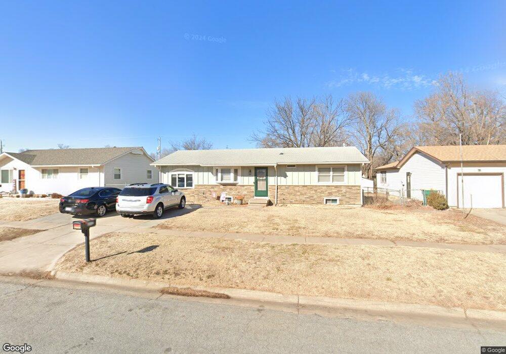
352 W 6th St Haysville, KS 67060
Estimated Value: $203,000 - $207,794
2
Beds
2
Baths
2,128
Sq Ft
$97/Sq Ft
Est. Value
About This Home
This home is located at 352 W 6th St, Haysville, KS 67060 and is currently estimated at $205,397, approximately $96 per square foot. 352 W 6th St is a home located in Sedgwick County with nearby schools including Freeman Elementary School, Haysville Middle School, and Campus High School.
Ownership History
Date
Name
Owned For
Owner Type
Purchase Details
Closed on
Jul 27, 2011
Sold by
Secretary Of Veterans Affairs
Bought by
Mendenhall Nicholas A and Mendenhall Kathryn S
Current Estimated Value
Home Financials for this Owner
Home Financials are based on the most recent Mortgage that was taken out on this home.
Original Mortgage
$59,900
Interest Rate
4.17%
Mortgage Type
VA
Purchase Details
Closed on
Feb 15, 2011
Sold by
Taylor Richard W and Taylor April
Bought by
The Secretary Of Veterans Affairs
Purchase Details
Closed on
Oct 3, 2006
Sold by
Lounds Robert C and Lounds Lan T
Bought by
Taylor Richard W
Home Financials for this Owner
Home Financials are based on the most recent Mortgage that was taken out on this home.
Original Mortgage
$88,350
Interest Rate
6.37%
Mortgage Type
VA
Create a Home Valuation Report for This Property
The Home Valuation Report is an in-depth analysis detailing your home's value as well as a comparison with similar homes in the area
Home Values in the Area
Average Home Value in this Area
Purchase History
| Date | Buyer | Sale Price | Title Company |
|---|---|---|---|
| Mendenhall Nicholas A | $59,900 | Servicelink | |
| The Secretary Of Veterans Affairs | $61,691 | Servicelink | |
| Taylor Richard W | -- | None Available |
Source: Public Records
Mortgage History
| Date | Status | Borrower | Loan Amount |
|---|---|---|---|
| Previous Owner | Mendenhall Nicholas A | $59,900 | |
| Previous Owner | Taylor Richard W | $88,350 |
Source: Public Records
Tax History Compared to Growth
Tax History
| Year | Tax Paid | Tax Assessment Tax Assessment Total Assessment is a certain percentage of the fair market value that is determined by local assessors to be the total taxable value of land and additions on the property. | Land | Improvement |
|---|---|---|---|---|
| 2025 | $2,994 | $21,873 | $3,105 | $18,768 |
| 2023 | $2,994 | $19,355 | $1,944 | $17,411 |
| 2022 | $2,417 | $16,538 | $1,829 | $14,709 |
| 2021 | $2,300 | $15,457 | $1,829 | $13,628 |
| 2020 | $2,205 | $14,583 | $1,829 | $12,754 |
| 2019 | $2,087 | $13,755 | $1,829 | $11,926 |
| 2018 | $1,973 | $13,099 | $1,426 | $11,673 |
| 2017 | $1,978 | $0 | $0 | $0 |
| 2016 | $1,921 | $0 | $0 | $0 |
| 2015 | $1,921 | $0 | $0 | $0 |
| 2014 | $1,810 | $0 | $0 | $0 |
Source: Public Records
Map
Nearby Homes
- 449 W 4th St
- 415 Spring Dr
- 221 River Birch St
- 242 Wire Ave
- 214 Stearns Ave
- 1204 W Leonard St
- 2200-2202 E Plaza Ct
- 2114-2116 E Plaza Ct
- 2120-2122 E Plaza Ct
- 2108-2110 E Plaza Ct
- 2100 E Plaza Ct
- 2100-2102 E Plaza Ct
- 200 Sunset Ave
- 238 Western Ave
- 181 Sunset Ave
- 150 Sunset Ave
- 115 Hungerford Ave
- 504 S Shira Cir
- 1509 W 4th St
- 616 E Peach Ave