Estimated Value: $260,000 - $345,000
3
Beds
2
Baths
1,244
Sq Ft
$237/Sq Ft
Est. Value
About This Home
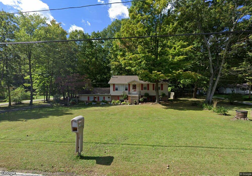
This home is located at 3522 Verner Rd, Kent, OH 44240 and is currently estimated at $294,496, approximately $236 per square foot. 3522 Verner Rd is a home located in Summit County with nearby schools including Stow-Munroe Falls High School and St Patrick Elementary School.
Ownership History
Date
Name
Owned For
Owner Type
Purchase Details
Closed on
Jan 26, 2007
Sold by
Jones Joyce C and Jones Dennis K
Bought by
Thomas Blaine M and Brave Larinda
Current Estimated Value
Home Financials for this Owner
Home Financials are based on the most recent Mortgage that was taken out on this home.
Original Mortgage
$115,920
Outstanding Balance
$69,662
Interest Rate
6.22%
Mortgage Type
Purchase Money Mortgage
Estimated Equity
$224,834
Create a Home Valuation Report for This Property
The Home Valuation Report is an in-depth analysis detailing your home's value as well as a comparison with similar homes in the area
Home Values in the Area
Average Home Value in this Area
Purchase History
| Date | Buyer | Sale Price | Title Company |
|---|---|---|---|
| Thomas Blaine M | $144,900 | Lawyers Title Ins |
Source: Public Records
Mortgage History
| Date | Status | Borrower | Loan Amount |
|---|---|---|---|
| Open | Thomas Blaine M | $115,920 |
Source: Public Records
Tax History
| Year | Tax Paid | Tax Assessment Tax Assessment Total Assessment is a certain percentage of the fair market value that is determined by local assessors to be the total taxable value of land and additions on the property. | Land | Improvement |
|---|---|---|---|---|
| 2024 | $5,549 | $82,401 | $13,815 | $68,586 |
| 2023 | $5,549 | $82,401 | $13,815 | $68,586 |
| 2022 | $5,043 | $64,950 | $10,878 | $54,072 |
| 2021 | $4,603 | $64,950 | $10,878 | $54,072 |
| 2020 | $4,545 | $64,950 | $10,880 | $54,070 |
| 2019 | $3,802 | $48,190 | $10,880 | $37,310 |
| 2018 | $3,751 | $48,190 | $10,880 | $37,310 |
| 2017 | $3,537 | $48,190 | $10,880 | $37,310 |
| 2016 | $3,506 | $42,300 | $10,880 | $31,420 |
| 2015 | $3,537 | $42,300 | $10,880 | $31,420 |
| 2014 | $3,539 | $42,300 | $10,880 | $31,420 |
| 2013 | $3,567 | $43,050 | $10,880 | $32,170 |
Source: Public Records
Map
Nearby Homes
- 350 Silver Meadows Blvd
- 1245 Chelton Dr
- 1302 Carol Dr
- 1189 Garth Dr
- 511 Suzanne Dr
- 3313 Crown Pointe Dr
- 884 Highridge Ln
- 726 Hughey Dr
- 895 Highridge Ln
- 3753 Lake Run Blvd
- 3767 Lake Run Blvd
- 2721 Santa Anita Dr
- 876 Middlebury Rd
- 0 Middlebury Rd
- 3874 Lake Run Blvd
- 957 Edgewater Cir Unit 20
- 3958 Lake Run Blvd
- 994 Erin Dr
- 3905 Kent Rd
- 1067 Erin Dr
- 3536 Verner Rd
- 3510 Verner Rd
- 3519 Verner Rd
- 3500 Verner Rd
- 3527 Verner Rd
- 3512 Verner Rd
- 3509 Verner Rd
- 3490 Verner Rd
- 3497 Verner Rd Unit 3501
- 3065 Powell Rd
- 4690 Kent Rd
- 3489 Verner Rd
- 4662 Kent Rd
- 4662 Kent Rd
- 3506 Deidrick Rd
- 4700 Kent Rd
- 3474 Verner Rd
- 3530 Deidrick Rd
- 3500 Deidrick Rd
- 3060 Powell Rd
Your Personal Tour Guide
Ask me questions while you tour the home.