


353 E Butterfield Rd Elmhurst, IL 60126
Estimated payment $3,854/month
Total Views
86,149
2
Beds
2
Baths
2,179
Sq Ft
$252
Price per Sq Ft
Highlights
- Hot Property
- Above Ground Pool
- Property is near a park
- Jefferson Elementary School Rated A
- Open Floorplan
- 4-minute walk to Butterfield Park
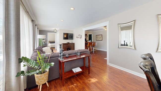
About This Home
Gorgeous and meticulously maintained ranch home on a spacious 0.33-acre lot in sought-after Elmhurst! Located in highly acclaimed District 205 with York High School! Features a dramatic circular driveway and 2.5-car side-load garage. Open concept layout with 2 bedrooms, 2 full baths, radiant heated floors throughout, and flexible living spaces. The cozy dining room offers a stunning stacked stone wood-burning fireplace and French doors that open to your backyard oasis. Updated gourmet kitchen (2013) with oversized island seating for 6, stainless appliances, Garland commercial-grade stove with double oven & 6 burners, wine fridge, and more. The luxurious primary suite includes a large walk-in closet plus two additional closets, and a spa-like bath with walk-in shower, jetted tub, and elegant finishes. Spacious second bedroom also features a custom walk-in closet. Versatile family room off the kitchen is currently used as a 3rd bedroom/office/workout space. Additional office could serve as a mudroom. Enjoy the private, fully fenced backyard with mature trees, a huge brick paver patio (2017), built-in firepit, brick wood-burning fireplace, above-ground pool, and two sheds. Updates include: GE washer/dryer (2022), garage door (2020), water heater (2014), roof (2011), boiler (2004). Exterior cellar door leads to partial basement for ample storage. Adjacent to the amazing Butterfield Park with adaptive playground, ball diamond, pickleball court, lighted tennis courts, recreation building, running/walking trails, soccer fields and lacrosse field! A rare find-don't miss this one!
Home Details
Home Type
- Single Family
Est. Annual Taxes
- $11,515
Year Built
- Built in 1951
Lot Details
- 0.33 Acre Lot
- Lot Dimensions are 96 x 170
- Fenced
- Corner Lot
- Paved or Partially Paved Lot
Parking
- 2.5 Car Garage
- Driveway
- Parking Included in Price
Home Design
- Ranch Style House
- Brick Exterior Construction
- Asphalt Roof
- Concrete Perimeter Foundation
Interior Spaces
- 2,179 Sq Ft Home
- Open Floorplan
- Ceiling Fan
- Wood Burning Fireplace
- Window Screens
- Mud Room
- Family Room
- Living Room
- Dining Room with Fireplace
- Formal Dining Room
- Home Office
- Storage Room
- Basement
- Sump Pump
- Carbon Monoxide Detectors
Kitchen
- Double Oven
- Range with Range Hood
- Microwave
- Dishwasher
- Wine Refrigerator
- Stainless Steel Appliances
Flooring
- Parquet
- Laminate
Bedrooms and Bathrooms
- 2 Bedrooms
- 2 Potential Bedrooms
- Walk-In Closet
- Bathroom on Main Level
- 2 Full Bathrooms
- Dual Sinks
- Shower Body Spray
Laundry
- Laundry Room
- Dryer
- Washer
Outdoor Features
- Above Ground Pool
- Patio
- Shed
Location
- Property is near a park
Schools
- Jefferson Elementary School
- Bryan Middle School
- York Community High School
Utilities
- Heating System Uses Natural Gas
- Radiant Heating System
- 200+ Amp Service
- Lake Michigan Water
- Cable TV Available
Community Details
- Ranch
Listing and Financial Details
- Homeowner Tax Exemptions
Matterport 3D Tour
Floorplan
Map
Create a Home Valuation Report for This Property
The Home Valuation Report is an in-depth analysis detailing your home's value as well as a comparison with similar homes in the area
Home Values in the Area
Average Home Value in this Area
Tax History
| Year | Tax Paid | Tax Assessment Tax Assessment Total Assessment is a certain percentage of the fair market value that is determined by local assessors to be the total taxable value of land and additions on the property. | Land | Improvement |
|---|---|---|---|---|
| 2024 | $11,515 | $199,075 | $136,678 | $62,397 |
| 2023 | $10,690 | $184,090 | $126,390 | $57,700 |
| 2022 | $10,368 | $176,980 | $121,500 | $55,480 |
| 2021 | $10,111 | $172,580 | $118,480 | $54,100 |
| 2020 | $9,720 | $168,790 | $115,880 | $52,910 |
| 2019 | $9,515 | $160,470 | $110,170 | $50,300 |
| 2018 | $9,888 | $165,610 | $104,290 | $61,320 |
| 2017 | $9,673 | $157,810 | $99,380 | $58,430 |
| 2016 | $9,470 | $148,660 | $93,620 | $55,040 |
| 2015 | $9,378 | $138,500 | $87,220 | $51,280 |
| 2014 | $7,150 | $98,780 | $79,620 | $19,160 |
| 2013 | $7,074 | $100,170 | $80,740 | $19,430 |
Source: Public Records
Property History
| Date | Event | Price | List to Sale | Price per Sq Ft |
|---|---|---|---|---|
| 11/05/2025 11/05/25 | Price Changed | $550,000 | -4.3% | $252 / Sq Ft |
| 10/10/2025 10/10/25 | For Sale | $575,000 | -- | $264 / Sq Ft |
Source: Midwest Real Estate Data (MRED)
Purchase History
| Date | Type | Sale Price | Title Company |
|---|---|---|---|
| Deed | $325,000 | Republic Title Company | |
| Warranty Deed | $200,000 | -- |
Source: Public Records
Mortgage History
| Date | Status | Loan Amount | Loan Type |
|---|---|---|---|
| Open | $316,761 | FHA |
Source: Public Records
About the Listing Agent
Julie Roback is a full-time real estate professional with over 31 years of sales experience serving communities in the Chicago Western Suburbs. Her job is to make your real estate dreams a reality. The foundation of her business is honesty, integrity, reliability and unwavering dedication to my clients. Julie’s high energy and knowledge of the current market trends enable her to fulfill the specific needs and desires of each unique client and always make the process truly exciting!
In
Julie's Other Listings
Source: Midwest Real Estate Data (MRED)
MLS Number: 12482901
APN: 06-13-204-018
Disclaimer: Certain information contained herein is derived from information provided by parties other than Homes.com. All information provided is deemed reliable, but is not guaranteed to be accurate and should be independently verified.
![]() Based on information submitted to the MLS GRID. All data is obtained from various sources and may not have been verified by broker or MLS GRID. Supplied Open House Information is subject to change without notice. All information should be independently reviewed and verified for accuracy. Properties may or may not be listed by the office/agent presenting the information. Some IDX listings have been excluded from this website.
Based on information submitted to the MLS GRID. All data is obtained from various sources and may not have been verified by broker or MLS GRID. Supplied Open House Information is subject to change without notice. All information should be independently reviewed and verified for accuracy. Properties may or may not be listed by the office/agent presenting the information. Some IDX listings have been excluded from this website.
The Digital Millennium Copyright Act of 1998, 17 U.S.C. § 512 (the “DMCA”) provides recourse for copyright owners who believe that material appearing on the Internet infringes their rights under U.S. copyright law. If you believe in good faith that any content or material made available in connection with our website or services infringes your copyright, you (or your agent) may send us a notice requesting that the content or material be removed, or access to it blocked.
Notices must be sent in writing by email to DMCAnotice@MLSGrid.com.
The DMCA requires that your notice of alleged copyright infringement include the following information:
(1) description of the copyrighted work that is the subject of claimed infringement;
(2) description of the alleged infringing content and information sufficient to permit us to locate the content;
(3) contact information for you, including your address, telephone number and email address;
(4) a statement by you that you have a good faith belief that the content in the manner complained of is not authorized by the copyright owner, or its agent, or by the operation of any law;
(5) a statement by you, signed under penalty of perjury, that the information in the notification is accurate and that you have the authority to enforce the copyrights that are claimed to be infringed; and
(6) a physical or electronic signature of the copyright owner or a person authorized to act on the copyright owner’s behalf. Failure to include all of the above information may result in the delay of the processing of your complaint.
Nearby Homes
- 900 S Colfax Ave
- 426 E Harrison St
- 427 E Adams St
- 15W320 Concord St
- 441 E Adams St
- 341 E Madison St
- 827 S Kearsage Ave
- 522 E Park Manor Ct
- 162 E Hale St
- 0S424 S Cadwell Ave
- 142 E Quincy St
- 494 E Atwood Ct
- 505 E Atwood Ct
- 675 S Edgewood Ave
- 185 E Oneida Ave
- 274 E Crescent Ave
- 100 W Butterfield Rd Unit 112N
- 110 W Butterfield Rd Unit 502S
- 613 S Chatham Ave
- 694 S York St
- 100 W Butterfield Rd Unit 101N
- 482 E Vallette St
- 122 E Crescent Ave
- 236 W Adams St
- 1171 S Eldridge Ln
- 1 Elm Creek Dr Unit 1030
- 7 Birch Tree Ct
- 1200 S Prospect Ave Unit 303
- 846 S Hawthorne Ave
- 483 S Argyle Ave
- 500 S Spring Rd Unit 1
- 5809 Huron St
- 510 E Park Ave
- 310 W Hillside Ave
- 1331 Heidorn Ave
- 2150 Mcdonalds Dr
- 105 S Arlington Ave Unit 204
- 135 S York St Unit 314
- 1905 S Wolf Rd
- 100 Haven Rd