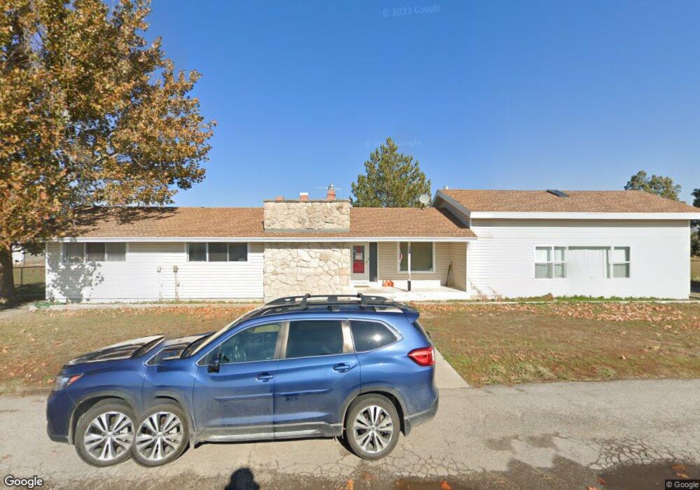
3534 W 5600 S Spanish Fork, UT 84660
Estimated Value: $1,082,000 - $1,827,200
4
Beds
2
Baths
2,422
Sq Ft
$601/Sq Ft
Est. Value
About This Home
This home is located at 3534 W 5600 S, Spanish Fork, UT 84660 and is currently estimated at $1,454,600, approximately $600 per square foot. 3534 W 5600 S is a home located in Utah County with nearby schools including Brockbank Elementary School, Spanish Fork Jr High School, and Spanish Fork High School.
Ownership History
Date
Name
Owned For
Owner Type
Purchase Details
Closed on
Sep 19, 2013
Sold by
Steele Lucille M and The Que & Lucile Steele Family
Bought by
Que And Lu Akeshore Llc
Current Estimated Value
Purchase Details
Closed on
May 2, 2008
Sold by
Harrison Stephanie A
Bought by
Steele Robert Q and Steele Lucile M
Purchase Details
Closed on
Aug 3, 2006
Sold by
Harrison Stephanie
Bought by
Harrison Stephanie A
Home Financials for this Owner
Home Financials are based on the most recent Mortgage that was taken out on this home.
Original Mortgage
$86,000
Interest Rate
6.76%
Mortgage Type
Credit Line Revolving
Create a Home Valuation Report for This Property
The Home Valuation Report is an in-depth analysis detailing your home's value as well as a comparison with similar homes in the area
Home Values in the Area
Average Home Value in this Area
Purchase History
| Date | Buyer | Sale Price | Title Company |
|---|---|---|---|
| Que And Lu Akeshore Llc | -- | None Available | |
| Steele Robert Q | -- | First American Lenders Pi | |
| Harrison Stephanie A | -- | First American Title Agency | |
| Harrison Stephanie | -- | First American Title Agency |
Source: Public Records
Mortgage History
| Date | Status | Borrower | Loan Amount |
|---|---|---|---|
| Previous Owner | Harrison Stephanie | $86,000 |
Source: Public Records
Tax History Compared to Growth
Tax History
| Year | Tax Paid | Tax Assessment Tax Assessment Total Assessment is a certain percentage of the fair market value that is determined by local assessors to be the total taxable value of land and additions on the property. | Land | Improvement |
|---|---|---|---|---|
| 2025 | $3,412 | $400,599 | $1,108,600 | $566,500 |
| 2024 | $3,412 | $341,031 | $0 | $0 |
| 2023 | $3,281 | $328,213 | $0 | $0 |
| 2022 | $3,258 | $1,547,700 | $1,125,700 | $422,000 |
| 2021 | $2,921 | $1,025,300 | $701,900 | $323,400 |
| 2020 | $2,659 | $941,200 | $617,800 | $323,400 |
| 2019 | $2,434 | $742,300 | $445,100 | $297,200 |
| 2018 | $2,277 | $683,600 | $425,100 | $258,500 |
| 2017 | $2,324 | $180,659 | $0 | $0 |
| 2016 | $2,540 | $191,454 | $0 | $0 |
| 2015 | $2,474 | $184,918 | $0 | $0 |
| 2014 | $2,890 | $185,265 | $0 | $0 |
Source: Public Records
Map
Nearby Homes
- 5310 S 3200 W
- 5884 S 3200 W
- 6612 S 3200 W
- 6668 S 3200 W
- 5272 S River Ln
- 6692 S 3200 W
- 5200 S River Dr Unit 3
- 4248 S 3200 W
- 2968 W 7300 S
- 2182 W 4600 S
- 6550 S 1050 W
- 1068 S 3440 E Unit 120
- 1085 S 3440 E Unit 107
- 5500 W 5600 S
- 1299 W 250 S
- 1377 W 450 S
- 429 S 1280 W
- 333 S 1170 W
- Aspen Plan at River Point
- Solitude Plan at River Point