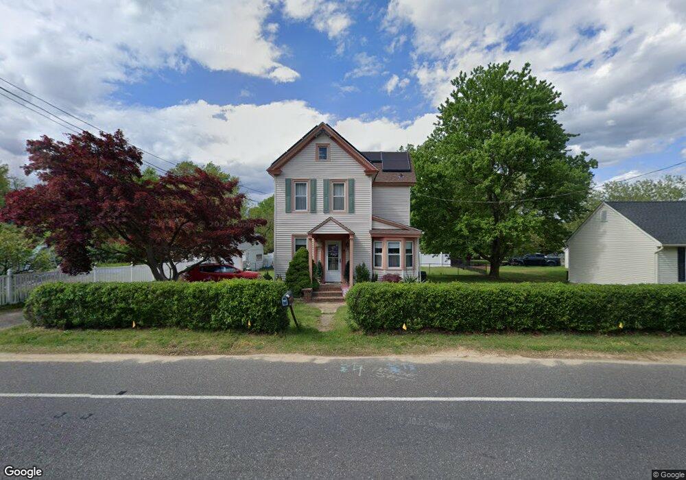
354 Berkley Rd Mantua, NJ 08051
Mantua Township NeighborhoodEstimated Value: $271,000 - $341,000
--
Bed
--
Bath
1,458
Sq Ft
$214/Sq Ft
Est. Value
About This Home
This home is located at 354 Berkley Rd, Mantua, NJ 08051 and is currently estimated at $311,764, approximately $213 per square foot. 354 Berkley Rd is a home located in Gloucester County with nearby schools including Centre City School, Clearview Regional Middle School, and Clearview Regional High School.
Ownership History
Date
Name
Owned For
Owner Type
Purchase Details
Closed on
Jun 19, 1997
Sold by
Craft Linda J Quenzel and Perkins Linda J
Bought by
Perkins James L and Perkins Linda J
Current Estimated Value
Home Financials for this Owner
Home Financials are based on the most recent Mortgage that was taken out on this home.
Original Mortgage
$153,000
Interest Rate
7.87%
Mortgage Type
Balloon
Purchase Details
Closed on
May 9, 1996
Sold by
Craft Linda J Quenzel
Bought by
Craft Linda J Quenzel and Perkins James L
Create a Home Valuation Report for This Property
The Home Valuation Report is an in-depth analysis detailing your home's value as well as a comparison with similar homes in the area
Home Values in the Area
Average Home Value in this Area
Purchase History
| Date | Buyer | Sale Price | Title Company |
|---|---|---|---|
| Perkins James L | -- | -- | |
| Craft Linda J Quenzel | -- | -- |
Source: Public Records
Mortgage History
| Date | Status | Borrower | Loan Amount |
|---|---|---|---|
| Closed | Perkins James L | $153,000 |
Source: Public Records
Tax History Compared to Growth
Tax History
| Year | Tax Paid | Tax Assessment Tax Assessment Total Assessment is a certain percentage of the fair market value that is determined by local assessors to be the total taxable value of land and additions on the property. | Land | Improvement |
|---|---|---|---|---|
| 2025 | $6,806 | $264,300 | $48,800 | $215,500 |
| 2024 | $6,734 | $264,300 | $48,800 | $215,500 |
| 2023 | $6,734 | $264,300 | $48,800 | $215,500 |
| 2022 | $5,146 | $147,100 | $40,800 | $106,300 |
| 2021 | $4,792 | $147,100 | $40,800 | $106,300 |
| 2020 | $5,143 | $147,100 | $40,800 | $106,300 |
| 2019 | $5,056 | $147,100 | $40,800 | $106,300 |
| 2018 | $4,984 | $147,100 | $40,800 | $106,300 |
| 2017 | $4,909 | $147,100 | $40,800 | $106,300 |
| 2016 | $4,853 | $147,100 | $40,800 | $106,300 |
| 2015 | $4,734 | $147,100 | $40,800 | $106,300 |
| 2014 | $4,575 | $147,100 | $40,800 | $106,300 |
Source: Public Records
Map
Nearby Homes
- 1147 Tristram Cir Unit 1147
- 1145 Tristram Cir
- 1121 Tristram Cir Unit 1
- 1134 Tristram Cir Unit 4
- 1215 Tristram Cir
- 205 Redbud Ln Unit 205
- 1433 Tristram Cir
- 433 Berkley Rd
- 19 Marathon Dr
- 106 Firth Dr
- 75 Hickory Ave
- 8 Barry Dr
- 261 Tony Cir
- 131 Firth Dr
- 325 Bridgeton Pike
- 465 Berkley Rd
- 204 W Landing Rd
- 190 Mockingbird Ln
- 485 Harrison Ave
- 36 Bluebird Rd
- 180 Woodlawn Ave
- 196 Woodlawn Ave
- 0 Berkley Rd
- 358 Berkley Rd
- 188 Norwood Ave
- 360 Berkley Rd
- 340 Berkley Rd
- 189 Woodlawn Ave
- 172 Woodlawn Ave
- 1170 Tristram Cir
- 1179 Tristram Cir Unit 9
- 1178 Tristram Cir Unit 1178
- 1172 Tristram Cir Unit 2
- 1176 Tristram Cir Unit 6
- 184 Norwood Ave
- 1173 Tristram Cir Unit 1173
- 1175 Tristram Cir Unit 155
- 1174 Tristram Cir
- 183 Woodlawn Ave
- 1180 Tristram Cir