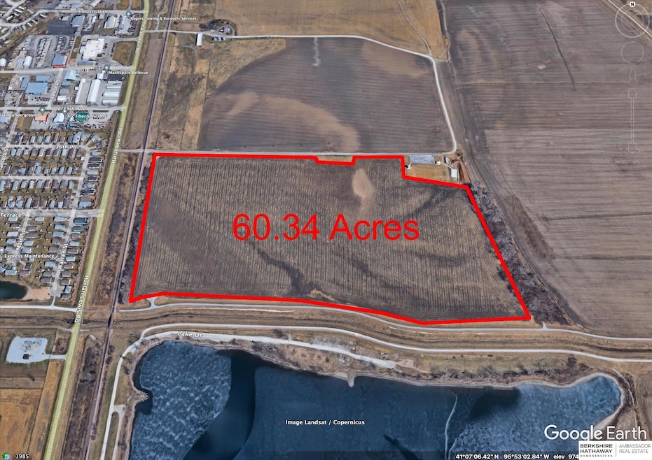

3545 Harlan Lewis Rd Bellevue, NE 68005
Estimated payment $9,849/month
Highlights
- 60.34 Acre Lot
- Farm
- No HOA
About This Lot
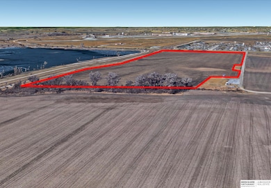
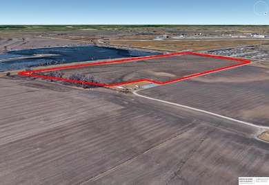
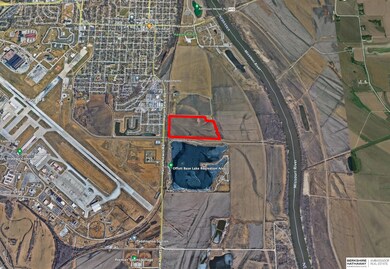
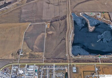
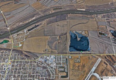
Large Gun Range on 60.34 acres of farm ground currently being farmed. This opportunity has a six position firing range , small tower, and power. Currently being rented with a yearly lease. This ground is off Harlan Lewis Road in Sarpy county next to the Base Lake off paved roads, south of Bellevue NE .

Property Details
Property Type
- Land
Est. Annual Taxes
- $5,219
Lot Details
- 60.34 Acre Lot
- Property is zoned Ag
Home Design
- Tar and Gravel Roof
Schools
- Bellevue Elementary School
- Bellevue Mission Middle School
- Bellevue East High School
Additional Features
- Farm
- Sewer Not Available
Community Details
- No Home Owners Association
Listing and Financial Details
- Assessor Parcel Number 010629336
Map
Home Values in the Area
Average Home Value in this Area
Tax History
| Year | Tax Paid | Tax Assessment Tax Assessment Total Assessment is a certain percentage of the fair market value that is determined by local assessors to be the total taxable value of land and additions on the property. | Land | Improvement |
|---|---|---|---|---|
| 2025 | $4,502 | $402,691 | $402,691 | -- |
| 2024 | $5,067 | $339,243 | $339,243 | -- |
| 2023 | $5,067 | $307,986 | $307,986 | -- |
| 2022 | $5,119 | $302,588 | $302,588 | $0 |
| 2021 | $5,219 | $302,588 | $302,588 | $0 |
| 2020 | $1,538 | $88,382 | $88,382 | $0 |
| 2019 | $1,598 | $92,472 | $92,472 | $0 |
| 2018 | $5,048 | $302,039 | $302,039 | $0 |
| 2017 | $5,103 | $302,039 | $302,039 | $0 |
| 2016 | $5,703 | $343,267 | $343,267 | $0 |
| 2015 | $5,256 | $325,124 | $325,124 | $0 |
| 2014 | $4,091 | $250,933 | $250,933 | $0 |
| 2012 | -- | $221,315 | $221,315 | $0 |
Property History
| Date | Event | Price | List to Sale | Price per Sq Ft |
|---|---|---|---|---|
| 07/02/2024 07/02/24 | For Sale | $1,795,000 | -- | -- |
Purchase History
| Date | Type | Sale Price | Title Company |
|---|---|---|---|
| Warranty Deed | $250,000 | Midwest Title Omaha | |
| Warranty Deed | -- | None Available | |
| Personal Reps Deed | -- | None Available | |
| Deed | -- | None Available |
Mortgage History
| Date | Status | Loan Amount | Loan Type |
|---|---|---|---|
| Open | $250,000 | No Value Available |
Source: Great Plains Regional MLS
MLS Number: 22416789
APN: 010629386
Disclaimer: Certain information contained herein is derived from information provided by parties other than Homes.com. All information provided is deemed reliable, but is not guaranteed to be accurate and should be independently verified.
![]() Listing information is provided by Participants of the Great Plains Regional Multiple Listing Service Inc.
Listing information is provided by Participants of the Great Plains Regional Multiple Listing Service Inc.
IDX information is provided exclusively for personal, non-commercial use, and may not be used for any purpose other than to identify prospective properties consumers may be interested in purchasing.
Information is deemed reliable but not guaranteed.
Copyright 2025, Great Plains Regional MLS LLC
- 306 Paradise Terrace
- 306 37th Place
- 3543 Warren Place
- 3101 Washington St Unit 15
- 3101 Washington St Unit 53
- 3101 Washington St Unit Lot 18
- 15122 Marseille Ave
- 831 Calais St
- 2905 Wayne St
- 101 E 28th Ave
- 912 Bordeaux Ave
- 1013 Bordeaux Ave
- 2807 Calhoun St
- 2604 Jackson St
- 2510 Hancock St
- 2411 Madison St
- 0000 Cedar Island Road East of Old 36th St
- 208 E 23rd Ave
- 2303 Madison St
- 2232 Wilson Dr
- 3606 Warren Ct
- 204 Paradise Terrace
- 306 E 37th Place
- 3543 Warren Place
- 311 E 36th Place
- 2911 Washington St
- 1029 Grenoble Dr
- 801 W 29th Ave
- 2806.5 Jackson St
- 2802 S Crawford St
- 2522 Hancock St
- 14102 Williamsburg Ct
- 110 E Mission Ave
- 2105 Washington St
- 1030 O'Malley Cir
- 1704 S Wayne St Unit 7
- 1729 Scarborough Dr
- 1605 Jefferson Ct
- 46 Martinview Rd
- 2315 Greenwald St