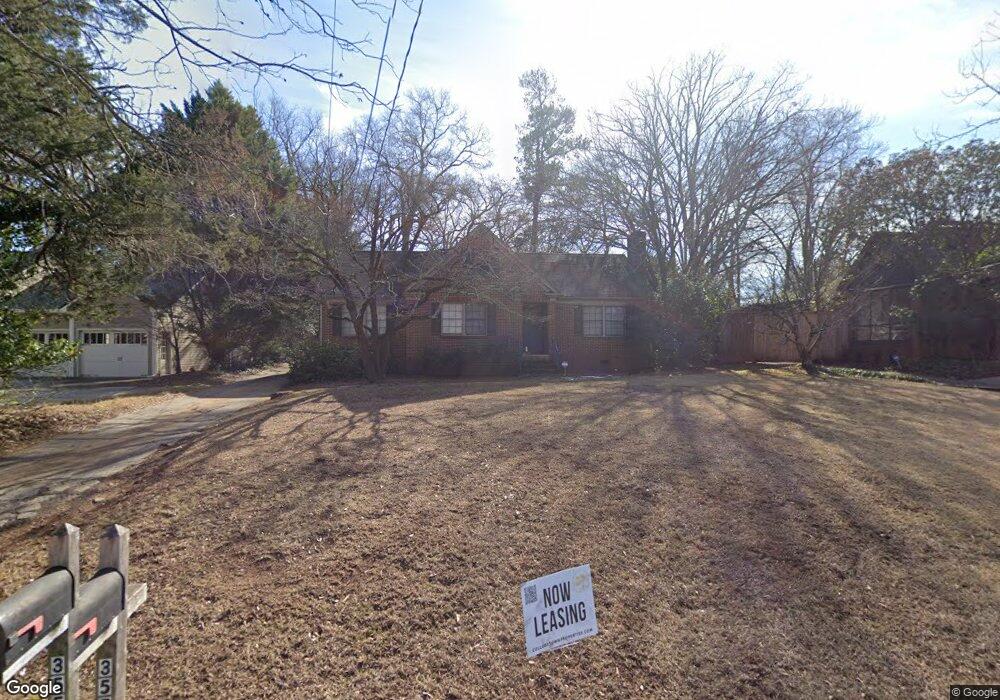
355 Springdale St Athens, GA 30606
Five Points NeighborhoodEstimated Value: $528,559 - $759,000
--
Bed
--
Bath
1,504
Sq Ft
$449/Sq Ft
Est. Value
About This Home
This home is located at 355 Springdale St, Athens, GA 30606 and is currently estimated at $675,890, approximately $449 per square foot. 355 Springdale St is a home located in Clarke County with nearby schools including Barrow Elementary School, Clarke Middle School, and Clarke Central High School.
Ownership History
Date
Name
Owned For
Owner Type
Purchase Details
Closed on
Oct 30, 2004
Sold by
Malcom Mitchell K and Malcom Susan J
Bought by
Malcom Properties Llc
Current Estimated Value
Purchase Details
Closed on
Nov 19, 2001
Sold by
Malcom Properties Llc
Bought by
Malcom Mitchell K and Malcom Susan J
Purchase Details
Closed on
Mar 18, 1999
Sold by
Malcom Development & Construction Inc
Bought by
Malcom Properties Llc
Purchase Details
Closed on
Jan 5, 1999
Sold by
James William T
Bought by
Malcom Development & Construction Inc
Create a Home Valuation Report for This Property
The Home Valuation Report is an in-depth analysis detailing your home's value as well as a comparison with similar homes in the area
Home Values in the Area
Average Home Value in this Area
Purchase History
| Date | Buyer | Sale Price | Title Company |
|---|---|---|---|
| Malcom Properties Llc | -- | -- | |
| Malcom Properties Llc | -- | -- | |
| Malcom Mitchell K | -- | -- | |
| Malcom Properties Llc | -- | -- | |
| Malcom Development & Construction Inc | $87,500 | -- |
Source: Public Records
Tax History Compared to Growth
Tax History
| Year | Tax Paid | Tax Assessment Tax Assessment Total Assessment is a certain percentage of the fair market value that is determined by local assessors to be the total taxable value of land and additions on the property. | Land | Improvement |
|---|---|---|---|---|
| 2025 | $6,094 | $196,258 | $74,000 | $122,258 |
| 2024 | $6,094 | $196,258 | $74,000 | $122,258 |
| 2023 | $6,133 | $196,258 | $74,000 | $122,258 |
| 2022 | $5,278 | $165,453 | $70,000 | $95,453 |
| 2021 | $5,419 | $160,788 | $70,000 | $90,788 |
| 2020 | $5,175 | $153,567 | $70,000 | $83,567 |
| 2019 | $5,034 | $148,272 | $70,000 | $78,272 |
| 2018 | $4,511 | $132,868 | $70,000 | $62,868 |
| 2017 | $4,307 | $126,851 | $70,000 | $56,851 |
| 2016 | $4,127 | $121,556 | $70,000 | $51,556 |
| 2015 | $3,711 | $109,149 | $60,000 | $49,149 |
| 2014 | $3,455 | $101,464 | $54,000 | $47,464 |
Source: Public Records
Map
Nearby Homes
- 265 Springdale St
- 338 Springdale St
- 577 W Cloverhurst Ave
- 1055 Baxter St Unit 504
- 495 Woodlawn Ave
- 997 S Milledge Ave Unit 2
- 997 S Milledge Ave Unit 3
- 997 S Milledge Ave Unit 1
- 997 S Milledge Ave Unit 4
- 255 Bloomfield St
- 206 Fortson Dr
- 169 Fortson Cir
- 50 Springdale St
- 224 Fortson Dr
- 597 Dearing St
- 490 Mcwhorter Dr
- 500 Dearing St Unit 6
- 1226 W Broad St
- 590 Highland Ave
- 494 Baxter St Unit 32
- 375 Springdale St
- 295 Springdale St
- 385 Springdale St
- 285 Springdale St
- 395 Springdale St
- 294 Springdale St
- 450 W Cloverhurst Ave
- 145 Stanton Way
- 328 Springdale St
- 440 W Cloverhurst Ave
- 484 W Cloverhurst Ave
- 125 Stanton Way
- 165 Stanton Way
- 497 S Rocksprings St
- 195 Stanton Way
- 402 W Cloverhurst Ave
- 255 Springdale St
- 496 S Rocksprings St
- 270 Springdale St
- 253 Springdale St