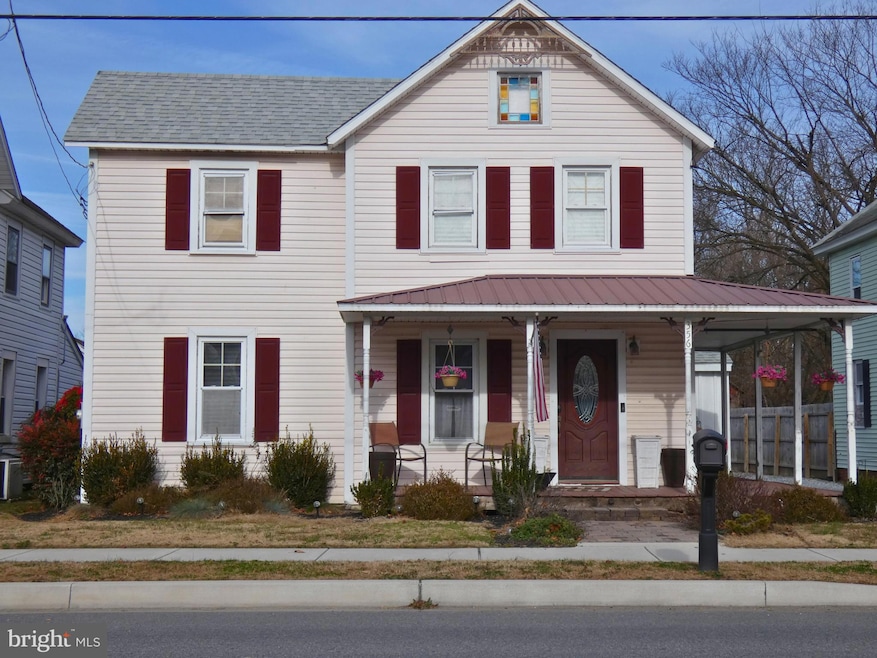
356 Cypress St Millington, MD 21651
Estimated payment $1,619/month
Highlights
- Traditional Floor Plan
- No HOA
- Eat-In Kitchen
- Farmhouse Style Home
- 1 Car Detached Garage
- Tankless Water Heater
About This Home
Coming soon! Looking for a 3 bed farmhouse in Millington with classic charm and modern updates? This warm and friendly 1920 single family home offers 1508 square feet on a 0.17 acre lot with a 2021 roof, vinyl siding, three second floor bedrooms, one full bath, and a half bath off the kitchen. A wrapped front and side porch sets the tone, while a rear wooden deck opens to the yard for easy outdoor living. The heated rear garage includes driveway parking and a setup that allows welder hookup, ideal for hobby work or small trades. Inside, the layout provides a cozy front living space, practical kitchen flow, and natural light throughout. Located in Millington with quick access to Route 301.
Listing Agent
(443) 480-2447 Billy@cbchesapeake.com Coldwell Banker Chesapeake Real Estate Company License #665813 Listed on: 12/09/2025

Co-Listing Agent
(443) 480-3580 Lacey@cbchesapeake.com Coldwell Banker Chesapeake Real Estate Company License #665749
Home Details
Home Type
- Single Family
Est. Annual Taxes
- $2,419
Year Built
- Built in 1920
Lot Details
- 7,405 Sq Ft Lot
- Property is zoned R-2
Parking
- 1 Car Detached Garage
- Parking Storage or Cabinetry
- Front Facing Garage
- Driveway
Home Design
- Farmhouse Style Home
- Vinyl Siding
Interior Spaces
- 1,508 Sq Ft Home
- Property has 2 Levels
- Traditional Floor Plan
- Combination Kitchen and Dining Room
- Crawl Space
Kitchen
- Eat-In Kitchen
- Stove
- Microwave
- Dishwasher
Bedrooms and Bathrooms
- 3 Bedrooms
Laundry
- Dryer
- Washer
Accessible Home Design
- Level Entry For Accessibility
Utilities
- Window Unit Cooling System
- Vented Exhaust Fan
- Electric Baseboard Heater
- Tankless Water Heater
- Propane Water Heater
Community Details
- No Home Owners Association
- Millington Subdivision
Listing and Financial Details
- Coming Soon on 12/21/25
- Assessor Parcel Number 1501008005
Map
Home Values in the Area
Average Home Value in this Area
Tax History
| Year | Tax Paid | Tax Assessment Tax Assessment Total Assessment is a certain percentage of the fair market value that is determined by local assessors to be the total taxable value of land and additions on the property. | Land | Improvement |
|---|---|---|---|---|
| 2025 | $2,205 | $161,600 | $0 | $0 |
| 2024 | $2,021 | $145,600 | $0 | $0 |
| 2023 | $1,858 | $129,600 | $45,600 | $84,000 |
| 2022 | $1,813 | $128,100 | $0 | $0 |
| 2021 | $3,560 | $126,600 | $0 | $0 |
| 2020 | $1,766 | $125,100 | $45,600 | $79,500 |
| 2019 | $3,425 | $125,100 | $45,600 | $79,500 |
| 2018 | $1,746 | $125,100 | $45,600 | $79,500 |
| 2017 | $1,635 | $126,700 | $0 | $0 |
| 2016 | -- | $126,700 | $0 | $0 |
| 2015 | $1,435 | $126,700 | $0 | $0 |
| 2014 | $1,435 | $128,300 | $0 | $0 |
Purchase History
| Date | Type | Sale Price | Title Company |
|---|---|---|---|
| Deed | $185,000 | Advantage Title Company Llc | |
| Deed | $60,000 | -- | |
| Deed | -- | -- | |
| Deed | $32,000 | -- |
Mortgage History
| Date | Status | Loan Amount | Loan Type |
|---|---|---|---|
| Open | $172,975 | FHA | |
| Closed | $172,975 | FHA |
Source: Bright MLS
MLS Number: MDKE2005972
APN: 01-008005
Disclaimer: Certain information contained herein is derived from information provided by parties other than Homes.com. All information provided is deemed reliable, but is not guaranteed to be accurate and should be independently verified.
![]() The data relating to real estate for sale on this website appears in part through the BRIGHT Internet Data Exchange program, a voluntary cooperative exchange of property listing data between licensed real estate brokerage firms, and is provided by BRIGHT through a licensing agreement.
The data relating to real estate for sale on this website appears in part through the BRIGHT Internet Data Exchange program, a voluntary cooperative exchange of property listing data between licensed real estate brokerage firms, and is provided by BRIGHT through a licensing agreement.
Listing information is from various brokers who participate in the Bright MLS IDX program and not all listings may be visible on the site.
The property information being provided on or through the website is for the personal, non-commercial use of consumers and such information may not be used for any purpose other than to identify prospective properties consumers may be interested in purchasing.
Some properties which appear for sale on the website may no longer be available because they are for instance, under contract, sold or are no longer being offered for sale.
Property information displayed is deemed reliable but is not guaranteed.
Copyright 2025 Bright MLS, Inc.
- 32155 River Rd
- 82 Kent Mill Dr
- Parcel 104 Pfalzgroff Rd
- 10434 Big Stone Rd
- 0 Carroll Clark Rd Unit MDKE2004182
- Lot 1 Carroll Clark Rd
- 10669 Chesterville Forest Rd
- 0 Chesterville Forest Rd Unit PARCEL 84A
- 0 Chesterville Forest Rd Unit PARCEL 60
- 0 Chesterville Forest Rd Unit PARCEL 73
- 0 Baxter Rd
- 0 Peters Corner Rd
- 218 Lakeside Dr
- 12035 Galena Rd
- 550 Bolton Woods Rd
- 32287 Quinn Rd
- 209 3rd St
- 404 Spring Rd
- 114 W Main St
- 112 W Main St
- 13951 Augustine Herman Hwy
- 203 E Main St
- 86 Longbow Ln Unit 86
- 54 Sherwood Forest Way Unit 54
- Unit 4 501 Main St
- 433 Main St
- 3 Kenton Cir
- 61 Pom Run Dr Unit 3
- 88 Smyrna Ave
- 319 Holly Ct
- 107 Summer Dr
- 109 Summer Dr
- 118 N Water St
- 631 W Mount Vernon St
- 304 Galloway St
- 17 Providence Dr
- 324 W North St
- 267 Doylestown
- 133 W South St Unit 1
- 101 Morgnec Rd