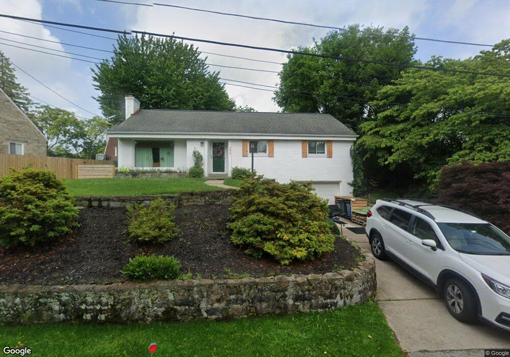
356 Hawthorne Rd Pittsburgh, PA 15209
Shaler Township NeighborhoodEstimated Value: $240,109 - $281,000
3
Beds
2
Baths
1,208
Sq Ft
$213/Sq Ft
Est. Value
About This Home
This home is located at 356 Hawthorne Rd, Pittsburgh, PA 15209 and is currently estimated at $257,777, approximately $213 per square foot. 356 Hawthorne Rd is a home located in Allegheny County with nearby schools including Marzolf Primary School, Shaler Area Elementary School, and Shaler Area Middle School.
Ownership History
Date
Name
Owned For
Owner Type
Purchase Details
Closed on
Nov 28, 2012
Sold by
Goetz Ex David R
Bought by
Bonaroti Mark
Current Estimated Value
Home Financials for this Owner
Home Financials are based on the most recent Mortgage that was taken out on this home.
Original Mortgage
$112,900
Outstanding Balance
$77,778
Interest Rate
3.25%
Mortgage Type
FHA
Estimated Equity
$179,999
Purchase Details
Closed on
May 20, 1976
Bought by
Goetz Edward and Goetz Olive M
Create a Home Valuation Report for This Property
The Home Valuation Report is an in-depth analysis detailing your home's value as well as a comparison with similar homes in the area
Home Values in the Area
Average Home Value in this Area
Purchase History
| Date | Buyer | Sale Price | Title Company |
|---|---|---|---|
| Bonaroti Mark | $115,000 | -- | |
| Goetz Edward | $42,500 | -- |
Source: Public Records
Mortgage History
| Date | Status | Borrower | Loan Amount |
|---|---|---|---|
| Open | Bonaroti Mark | $112,900 |
Source: Public Records
Tax History Compared to Growth
Tax History
| Year | Tax Paid | Tax Assessment Tax Assessment Total Assessment is a certain percentage of the fair market value that is determined by local assessors to be the total taxable value of land and additions on the property. | Land | Improvement |
|---|---|---|---|---|
| 2025 | $2,964 | $90,000 | $35,200 | $54,800 |
| 2024 | $2,964 | $90,000 | $35,200 | $54,800 |
| 2023 | $2,858 | $90,000 | $35,200 | $54,800 |
| 2022 | $2,858 | $90,000 | $35,200 | $54,800 |
| 2021 | $2,858 | $90,000 | $35,200 | $54,800 |
| 2020 | $2,858 | $90,000 | $35,200 | $54,800 |
| 2019 | $2,768 | $90,000 | $35,200 | $54,800 |
| 2018 | $426 | $90,000 | $35,200 | $54,800 |
| 2017 | $2,680 | $90,000 | $35,200 | $54,800 |
| 2016 | $426 | $90,000 | $35,200 | $54,800 |
| 2015 | $426 | $90,000 | $35,200 | $54,800 |
| 2014 | $2,570 | $90,000 | $35,200 | $54,800 |
Source: Public Records
Map
Nearby Homes
- 15 Old Soose Rd Unit A
- 14 Old Soose Rd
- 40 Emerson Rd
- 0 William St Unit 1701996
- 53 Elizabeth St
- 105 Tannen Dr
- 2 Sedum Dr
- 410 Winterset Dr
- LOT 303B Locust Ridge Dr
- 146 Buckeye Way
- 4 Franklin St
- 1031 Evergreen Ave
- 341 Mount Vernon Dr
- 115 Canby Dr
- 834 Evergreen Ave
- 174 Seavey Rd
- 720 Evergreen Ave
- 27 Ann St
- 37 Lawrence St
- 80 Parker St
- 356 Hawthorne Rd
- 400 Hawthorne Rd
- 352 Hawthorne Rd
- 406 Hawthorne Rd
- 352 Hawthorne Rd
- 410 Hawthorne Rd
- 355 Hawthorne Rd
- 416 Hawthorne Rd
- 353 Hawthorne Rd
- 373 Hawthorne Rd
- 426 Hawthorne Rd
- 401 Hawthorne Rd
- 351 Hawthorne Rd
- 344 Hawthorne Rd
- 120 Soose Rd
- 330 Hawthorne Rd
- 349 Hawthorne Rd
- 430 Hawthorne Rd
- 15 Old Soose Rd
- 15 Old Soose Rd