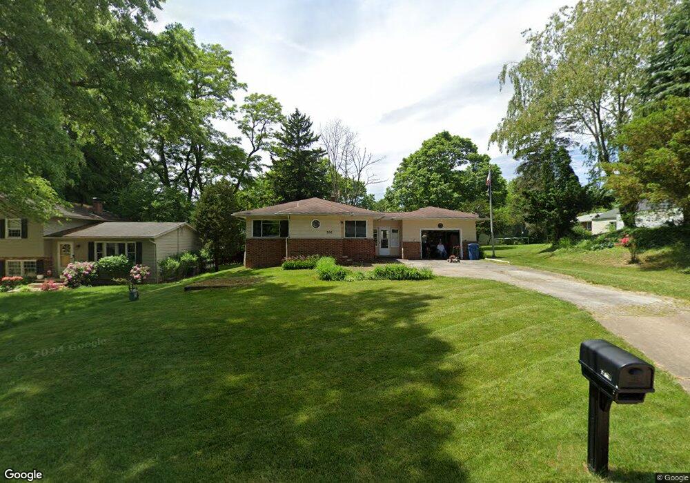
356 Owosso Ave Fairlawn, OH 44333
Estimated Value: $217,636 - $253,000
3
Beds
1
Bath
1,152
Sq Ft
$207/Sq Ft
Est. Value
About This Home
This home is located at 356 Owosso Ave, Fairlawn, OH 44333 and is currently estimated at $238,159, approximately $206 per square foot. 356 Owosso Ave is a home located in Summit County with nearby schools including Copley-Fairlawn Middle School, Copley High School, and Fairlawn Lutheran School.
Ownership History
Date
Name
Owned For
Owner Type
Purchase Details
Closed on
Apr 29, 2004
Sold by
Klein Douglas L and Klein Anita B
Bought by
Durgin Paul D and Kramer Ronnie R
Current Estimated Value
Home Financials for this Owner
Home Financials are based on the most recent Mortgage that was taken out on this home.
Original Mortgage
$126,000
Outstanding Balance
$56,111
Interest Rate
5%
Mortgage Type
Purchase Money Mortgage
Estimated Equity
$182,048
Purchase Details
Closed on
Sep 17, 1999
Sold by
Prunari Terry Tonie
Bought by
Klein Douglas L and Klein Anita B
Home Financials for this Owner
Home Financials are based on the most recent Mortgage that was taken out on this home.
Original Mortgage
$100,000
Interest Rate
7.93%
Create a Home Valuation Report for This Property
The Home Valuation Report is an in-depth analysis detailing your home's value as well as a comparison with similar homes in the area
Home Values in the Area
Average Home Value in this Area
Purchase History
| Date | Buyer | Sale Price | Title Company |
|---|---|---|---|
| Durgin Paul D | $145,000 | Miller Examining Service Inc | |
| Klein Douglas L | $125,000 | Title One Agency Inc |
Source: Public Records
Mortgage History
| Date | Status | Borrower | Loan Amount |
|---|---|---|---|
| Open | Durgin Paul D | $126,000 | |
| Closed | Klein Douglas L | $100,000 | |
| Closed | Klein Douglas L | $12,500 |
Source: Public Records
Tax History
| Year | Tax Paid | Tax Assessment Tax Assessment Total Assessment is a certain percentage of the fair market value that is determined by local assessors to be the total taxable value of land and additions on the property. | Land | Improvement |
|---|---|---|---|---|
| 2025 | $2,222 | $62,927 | $14,525 | $48,402 |
| 2024 | $2,147 | $62,927 | $14,525 | $48,402 |
| 2023 | $2,147 | $62,927 | $14,525 | $48,402 |
| 2022 | $1,917 | $48,405 | $11,172 | $37,233 |
| 2021 | $1,802 | $48,405 | $11,172 | $37,233 |
| 2020 | $1,762 | $48,400 | $11,170 | $37,230 |
| 2019 | $1,898 | $47,070 | $11,170 | $35,900 |
| 2018 | $1,860 | $47,070 | $11,170 | $35,900 |
| 2017 | $1,612 | $47,070 | $11,170 | $35,900 |
| 2016 | $1,610 | $39,760 | $11,170 | $28,590 |
| 2015 | $1,612 | $39,760 | $11,170 | $28,590 |
| 2014 | $1,606 | $39,760 | $11,170 | $28,590 |
| 2013 | $1,606 | $39,830 | $11,170 | $28,660 |
Source: Public Records
Map
Nearby Homes
- 2547 Sand Run Pkwy
- 151 Shiawassee Ave
- 2592 Falmouth Rd
- 441 Sandhurst Rd
- 2239 Woodpark Rd
- 2816 Riviera Dr
- 71 Winchester Rd
- 2854 Riviera Dr
- 364 Mowbray Rd
- 96 S Miller Rd
- 2901 Vesper Dr
- 898 Willow Creek Dr
- 178 Benson Rd
- 568 Hampshire Rd
- 2445 Chatham Rd
- 192 Durward Rd
- 483 Parkside Dr
- 3081 Bancroft Rd
- 131 N Wheaton Rd
- 240 Sand Run Rd
- 352 Owosso Ave
- 348 Owosso Ave
- 321 Corunna Ave
- 372 Owosso Ave
- 327 Corunna Ave
- 2642 Smith Rd
- 355 Owosso Ave
- 315 Corunna Ave
- 361 Owosso Ave
- 349 Owosso Ave
- 2648 Smith Rd
- 334 Owosso Ave
- 367 Owosso Ave
- 343 Owosso Ave
- 309 Corunna Ave
- 377 Owosso Ave
- 2641 Durand Rd
- 335 Owosso Ave
- 303 Corunna Ave
- 328 Corunna Ave
Your Personal Tour Guide
Ask me questions while you tour the home.