Estimated Value: $96,000 - $137,309
3
Beds
1
Bath
1,186
Sq Ft
$102/Sq Ft
Est. Value
About This Home
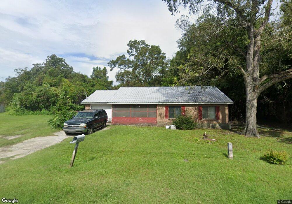
This home is located at 357 N Wayne St, Jesup, GA 31546 and is currently estimated at $120,577, approximately $101 per square foot. 357 N Wayne St is a home located in Wayne County with nearby schools including Martha Rawls Smith Elementary School, Arthur Williams Middle School, and Wayne County High School.
Ownership History
Date
Name
Owned For
Owner Type
Purchase Details
Closed on
Nov 16, 2024
Sold by
Dennard Michael
Bought by
Dennard Janice
Current Estimated Value
Purchase Details
Closed on
May 11, 2018
Sold by
Dennard Alma A
Bought by
Dennard Janice
Purchase Details
Closed on
Sep 1, 1990
Sold by
Farmers Home Administration
Bought by
Dennard Alma A
Purchase Details
Closed on
Aug 1, 1988
Bought by
Farmers Home Administration
Purchase Details
Closed on
Dec 1, 1981
Purchase Details
Closed on
Aug 1, 1981
Purchase Details
Closed on
Jan 1, 1973
Purchase Details
Closed on
Jan 1, 1954
Create a Home Valuation Report for This Property
The Home Valuation Report is an in-depth analysis detailing your home's value as well as a comparison with similar homes in the area
Purchase History
| Date | Buyer | Sale Price | Title Company |
|---|---|---|---|
| Dennard Janice | -- | -- | |
| Dennard Janice | -- | -- | |
| Dennard Alma A | $31,000 | -- | |
| Farmers Home Administration | $25,100 | -- | |
| -- | $35,000 | -- | |
| -- | $1,500 | -- | |
| -- | -- | -- | |
| -- | -- | -- |
Source: Public Records
Tax History
| Year | Tax Paid | Tax Assessment Tax Assessment Total Assessment is a certain percentage of the fair market value that is determined by local assessors to be the total taxable value of land and additions on the property. | Land | Improvement |
|---|---|---|---|---|
| 2025 | $1,103 | $37,258 | $2,500 | $34,758 |
| 2024 | $1,103 | $36,081 | $2,500 | $33,581 |
| 2023 | $626 | $21,310 | $1,476 | $19,834 |
| 2022 | $671 | $21,310 | $1,476 | $19,834 |
| 2021 | $719 | $21,310 | $1,476 | $19,834 |
| 2020 | $743 | $21,310 | $1,476 | $19,834 |
| 2019 | $766 | $21,310 | $1,476 | $19,834 |
| 2018 | $292 | $21,310 | $1,476 | $19,834 |
| 2017 | $211 | $21,310 | $1,476 | $19,834 |
| 2016 | $194 | $21,310 | $1,476 | $19,834 |
| 2014 | $194 | $21,310 | $1,476 | $19,834 |
| 2013 | -- | $21,309 | $1,476 | $19,833 |
Source: Public Records
Map
Nearby Homes
- 187 E Pine St
- 436-441 Brunswick St
- Apt E Oak St
- 385 N Hickory St
- 197 NW Broad St
- 498 NE Broad St
- 447 NE Broad St
- 169 Pine Ridge Rd
- 110 E Pine St
- 548 N Cypress St
- 0 E Oak St
- 111 N Mahogany St
- 241 S Elm Ln
- 286 S Wayne St
- 00 84 Hwy
- 104 Mangrove Ct
- 108 Mangrove Ct
- 102 Mangrove Ct
- 113 Mangrove Ct
- 661 E Plum St
- 362 N Brunswick Ln
- 355 N Wayne St
- 398 N Brunswick St
- 356 N Brunswick St
- 392 N Wayne St
- 380 N Wayne St
- 396 N Brunswick St
- 356 N Wayne St
- 398 N Wayne St
- 365 N Brunswick St
- 348 N Wayne St
- 342 N Wayne St
- 381 Whaley St
- 367 Whaley St
- 355 Whaley St
- 297 Railroad Ave
- 347 Whaley St
- 265 W Railroad Ave
- 335 Whaley St
- 211 E Pine St
Your Personal Tour Guide
Ask me questions while you tour the home.