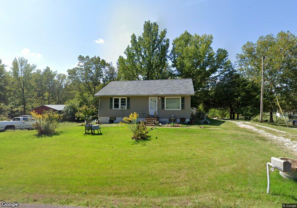
3576 Jarvis Rd Hillsboro, MO 63050
Estimated Value: $159,976 - $216,000
--
Bed
--
Bath
1,008
Sq Ft
$182/Sq Ft
Est. Value
About This Home
This home is located at 3576 Jarvis Rd, Hillsboro, MO 63050 and is currently estimated at $183,494, approximately $182 per square foot. 3576 Jarvis Rd is a home located in Jefferson County with nearby schools including Hillsboro Primary School, Hillsboro Elementary School, and Hillsboro Middle Elementary School.
Ownership History
Date
Name
Owned For
Owner Type
Purchase Details
Closed on
Feb 2, 2009
Sold by
Young Marvin W
Bought by
Young Teresa L
Current Estimated Value
Purchase Details
Closed on
Mar 30, 1998
Sold by
Mooney William A
Bought by
Anderson Teresa L
Purchase Details
Closed on
Dec 5, 1997
Sold by
Verneda Moser
Bought by
Mooney William A
Home Financials for this Owner
Home Financials are based on the most recent Mortgage that was taken out on this home.
Original Mortgage
$46,400
Interest Rate
6.5%
Create a Home Valuation Report for This Property
The Home Valuation Report is an in-depth analysis detailing your home's value as well as a comparison with similar homes in the area
Home Values in the Area
Average Home Value in this Area
Purchase History
| Date | Buyer | Sale Price | Title Company |
|---|---|---|---|
| Young Teresa L | -- | None Available | |
| Anderson Teresa L | -- | Commonwealth Title | |
| Mooney William A | -- | -- |
Source: Public Records
Mortgage History
| Date | Status | Borrower | Loan Amount |
|---|---|---|---|
| Previous Owner | Mooney William A | $46,400 |
Source: Public Records
Tax History Compared to Growth
Tax History
| Year | Tax Paid | Tax Assessment Tax Assessment Total Assessment is a certain percentage of the fair market value that is determined by local assessors to be the total taxable value of land and additions on the property. | Land | Improvement |
|---|---|---|---|---|
| 2025 | $853 | $14,900 | $2,100 | $12,800 |
| 2024 | $853 | $13,600 | $2,100 | $11,500 |
| 2023 | $853 | $13,600 | $2,100 | $11,500 |
| 2022 | $861 | $13,500 | $2,100 | $11,400 |
| 2021 | $920 | $13,500 | $2,100 | $11,400 |
| 2020 | $837 | $11,900 | $1,900 | $10,000 |
| 2019 | $837 | $11,900 | $1,900 | $10,000 |
| 2018 | $836 | $11,900 | $1,900 | $10,000 |
| 2017 | $795 | $11,900 | $1,900 | $10,000 |
| 2016 | $736 | $10,900 | $1,900 | $9,000 |
| 2015 | $654 | $10,900 | $1,900 | $9,000 |
| 2013 | $654 | $10,400 | $1,700 | $8,700 |
Source: Public Records
Map
Nearby Homes
- 176 Pancho Villa Dr
- 3644 Crestview Dr
- 9822 Woodland Rd
- 3532 Ketha Heights
- 3333 Ketha Cir
- 4 Cedar Creek
- 1 Appomattox Ridge
- 4005 Twinbrook Rd
- 9448 Ponderosa Ln
- 18 Meadow Ridge
- 9213 Church Dr
- 9365 Elm Loop Dr
- 4295 Hansard Ln
- 9904 Lockeport Point
- 2313 Oak Forest Dr
- 2305 Wright Place
- 0 Hwy A 62 Acres Unit 20012897
- 3900 Rice Rd
- 9341 Market St
- 1102 Stone Henge Ct
- 3564 Jarvis Rd
- 35883586 Jarvis Rd
- 3588 Jarvis Rd
- 3588 Jarvis Rd
- 3586 Jarvis Rd
- 3582 Jarvis Rd
- 8 Love Dr
- 3584 Jarvis Rd
- 7 Love Dr
- 149 Redecker Rd
- 3601 Jarvis Rd
- 0 Jarvis Rd
- 0 Jarvis Rd Unit 19004658
- 3600 Jarvis Rd
- 155 Redecker Rd
- 3625 Jarvis Rd
- 5 Love Dr
- 9411 Peace Meadows
- 3530 Jarvis Rd
- 150 Redecker Rd