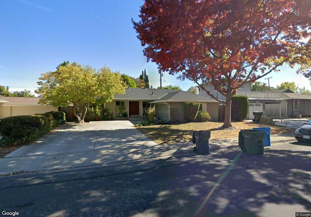
359 Howard Dr Santa Clara, CA 95051
North Cupertino NeighborhoodEstimated Value: $2,083,000 - $2,593,000
3
Beds
2
Baths
1,284
Sq Ft
$1,821/Sq Ft
Est. Value
About This Home
This home is located at 359 Howard Dr, Santa Clara, CA 95051 and is currently estimated at $2,338,800, approximately $1,821 per square foot. 359 Howard Dr is a home located in Santa Clara County with nearby schools including Dwight D. Eisenhower Elementary School, Warren E. Hyde Middle School, and Cupertino High School.
Ownership History
Date
Name
Owned For
Owner Type
Purchase Details
Closed on
Jan 26, 2013
Sold by
Li Liang Yao and Chien Tung Ching
Bought by
Li Liang Yao and Chien Tung Ching
Current Estimated Value
Purchase Details
Closed on
Jun 24, 1994
Sold by
Yeh James Jyh Gang and Yeh Doris Tau Wen
Bought by
Li Llang Yao and Chien Tung Ching
Home Financials for this Owner
Home Financials are based on the most recent Mortgage that was taken out on this home.
Original Mortgage
$203,150
Interest Rate
8.6%
Create a Home Valuation Report for This Property
The Home Valuation Report is an in-depth analysis detailing your home's value as well as a comparison with similar homes in the area
Home Values in the Area
Average Home Value in this Area
Purchase History
| Date | Buyer | Sale Price | Title Company |
|---|---|---|---|
| Li Liang Yao | -- | None Available | |
| Li Liang Yao | -- | None Available | |
| Li Llang Yao | $274,000 | Old Republic Title Company |
Source: Public Records
Mortgage History
| Date | Status | Borrower | Loan Amount |
|---|---|---|---|
| Closed | Li Llang Yao | $203,150 |
Source: Public Records
Tax History
| Year | Tax Paid | Tax Assessment Tax Assessment Total Assessment is a certain percentage of the fair market value that is determined by local assessors to be the total taxable value of land and additions on the property. | Land | Improvement |
|---|---|---|---|---|
| 2025 | $5,541 | $469,417 | $272,576 | $196,841 |
| 2024 | $5,541 | $460,214 | $267,232 | $192,982 |
| 2023 | $5,500 | $451,192 | $261,993 | $189,199 |
| 2022 | $5,641 | $442,346 | $256,856 | $185,490 |
| 2021 | $5,589 | $433,673 | $251,820 | $181,853 |
| 2020 | $5,528 | $429,227 | $249,238 | $179,989 |
| 2019 | $5,414 | $420,811 | $244,351 | $176,460 |
| 2018 | $5,295 | $412,560 | $239,560 | $173,000 |
| 2017 | $5,274 | $404,471 | $234,863 | $169,608 |
| 2016 | $5,114 | $396,541 | $230,258 | $166,283 |
| 2015 | $5,085 | $390,586 | $226,800 | $163,786 |
| 2014 | $4,947 | $382,936 | $222,358 | $160,578 |
Source: Public Records
Map
Nearby Homes
- 3453 Geneva Dr
- 10250 Bret Ave
- 18940 Loree Ave
- 1155 London Ave
- 1653 Waxwing Ave
- 216 Rodonovan Dr
- 720 Harvard Ave
- 10334 S Tantau Ave
- 587 Cambridge Dr
- 1780 Lark Ln
- 19735 Auburn Dr
- 3329 Mauricia Ave
- 10430 Stern Ave
- 19423 Greenwood Dr
- 141 Muir Ave
- 18891 Tilson Ave
- 835 Bing Dr Unit 21
- 835 Bing Dr Unit 24
- 835 Bing Dr Unit 29
- 496 Bevans Dr
Your Personal Tour Guide
Ask me questions while you tour the home.