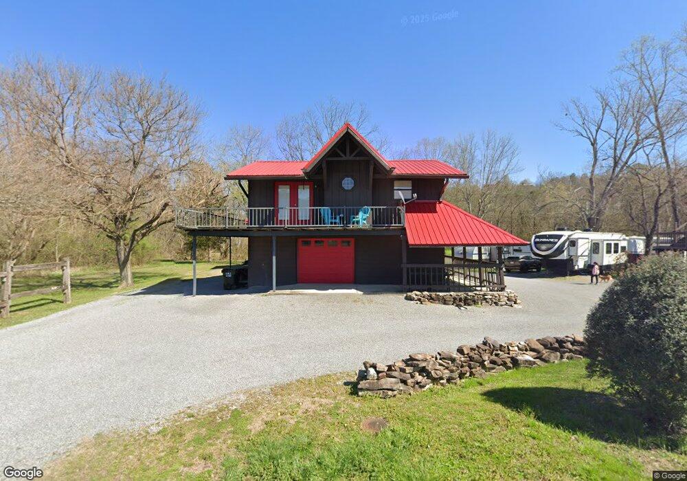
359 Walnut St Dunlap, TN 37327
Estimated Value: $153,000 - $224,000
2
Beds
2
Baths
852
Sq Ft
$212/Sq Ft
Est. Value
About This Home
This home is located at 359 Walnut St, Dunlap, TN 37327 and is currently estimated at $180,261, approximately $211 per square foot. 359 Walnut St is a home located in Sequatchie County with nearby schools including Griffith Elementary School, Sequatchie County Middle School, and Sequatchie County High School.
Ownership History
Date
Name
Owned For
Owner Type
Purchase Details
Closed on
Jun 23, 2016
Sold by
Mountain Valley Bank
Bought by
Davis Keith and Davis Darlene
Current Estimated Value
Purchase Details
Closed on
Jan 8, 2016
Sold by
Camp Carson
Bought by
Mountain Valley Bank
Purchase Details
Closed on
Sep 16, 1994
Sold by
Citizens Tri County Bank
Bought by
Carson Camp and Carson Joyce
Purchase Details
Closed on
Sep 9, 1994
Bought by
Camp Carson and Wife Joyce
Purchase Details
Closed on
Aug 3, 1994
Bought by
Citizens Tri-County Bank
Purchase Details
Closed on
Apr 7, 1993
Bought by
Bateman Loyd
Purchase Details
Closed on
Jan 1, 1981
Create a Home Valuation Report for This Property
The Home Valuation Report is an in-depth analysis detailing your home's value as well as a comparison with similar homes in the area
Home Values in the Area
Average Home Value in this Area
Purchase History
| Date | Buyer | Sale Price | Title Company |
|---|---|---|---|
| Davis Keith | $150,000 | -- | |
| Mountain Valley Bank | $162,000 | -- | |
| Carson Camp | -- | -- | |
| Camp Carson | $12,500 | -- | |
| Citizens Tri-County Bank | $4,800 | -- | |
| Bateman Loyd | $3,300 | -- | |
| -- | $1,500 | -- |
Source: Public Records
Tax History
| Year | Tax Paid | Tax Assessment Tax Assessment Total Assessment is a certain percentage of the fair market value that is determined by local assessors to be the total taxable value of land and additions on the property. | Land | Improvement |
|---|---|---|---|---|
| 2025 | $764 | $31,650 | $2,275 | $29,375 |
| 2024 | $764 | $31,650 | $2,275 | $29,375 |
| 2023 | $764 | $31,650 | $2,275 | $29,375 |
| 2022 | $577 | $17,400 | $2,175 | $15,225 |
| 2021 | $569 | $17,400 | $2,175 | $15,225 |
| 2020 | $269 | $17,400 | $2,175 | $15,225 |
| 2019 | $269 | $8,250 | $2,175 | $6,075 |
| 2018 | $266 | $8,250 | $2,175 | $6,075 |
| 2017 | $263 | $8,250 | $2,175 | $6,075 |
| 2016 | $241 | $7,250 | $2,175 | $5,075 |
| 2015 | $241 | $7,250 | $2,175 | $5,075 |
| 2014 | $241 | $7,250 | $2,175 | $5,075 |
Source: Public Records
Map
Nearby Homes
- Lot 13 B Greenfields Way
- 21550 U S 127
- 21552 U S 127
- 0 SE US Hwy 127 Unit 1519993
- 0 SE US Hwy 127 Unit 1519990
- 0 SE US Hwy 127 Unit 1519988
- 0 SE US Hwy 127 Unit 1314389
- 0 SE US Hwy 127 Unit 1519979
- 0 SE US Hwy 127 Unit 1519991
- 0 SE US Hwy 127 Unit 1519984
- 254 Cdl Trail
- 95 Blue Sky Rd Rd
- 410 Cherry St
- 407 Standifer Cir
- 0 State Rt 399 Lot 13
- 341 Oak St
- 252 Valley View Dr
- 95 A Main St
- 0 Jericho Rd Unit 1523837
- 0 Jericho Rd Unit Lot 11
Your Personal Tour Guide
Ask me questions while you tour the home.