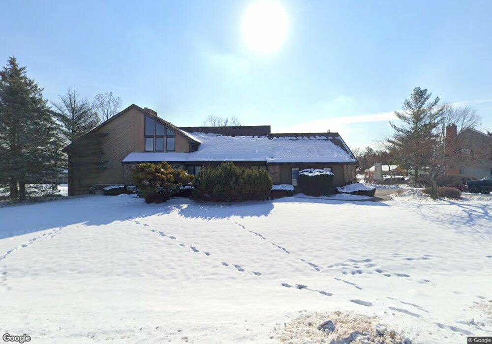
35W550 Parsons Rd Dundee, IL 60118
Estimated Value: $519,129 - $726,000
3
Beds
--
Bath
2,935
Sq Ft
$206/Sq Ft
Est. Value
About This Home
This home is located at 35W550 Parsons Rd, Dundee, IL 60118 and is currently estimated at $604,032, approximately $205 per square foot. 35W550 Parsons Rd is a home located in Kane County with nearby schools including Liberty Elementary School, Dundee Middle School, and Harry D Jacobs High School.
Ownership History
Date
Name
Owned For
Owner Type
Purchase Details
Closed on
Jun 14, 2023
Sold by
Kesaris Peter T and Kesaris Cynthia M
Bought by
Cynthia Marie Kesaris Revocable Living Trust and Peter Thomas Kesaris Revocable Living Trust
Current Estimated Value
Purchase Details
Closed on
Oct 22, 2014
Sold by
Kesaris Peter T and Kesaris Cynthia M
Bought by
Peter T Kesaris Revocable Living Trust and Cynthia M Kesaris Revocable Living Trust
Create a Home Valuation Report for This Property
The Home Valuation Report is an in-depth analysis detailing your home's value as well as a comparison with similar homes in the area
Home Values in the Area
Average Home Value in this Area
Purchase History
| Date | Buyer | Sale Price | Title Company |
|---|---|---|---|
| Cynthia Marie Kesaris Revocable Living Trust | -- | None Listed On Document | |
| Peter T Kesaris Revocable Living Trust | -- | None Available |
Source: Public Records
Tax History Compared to Growth
Tax History
| Year | Tax Paid | Tax Assessment Tax Assessment Total Assessment is a certain percentage of the fair market value that is determined by local assessors to be the total taxable value of land and additions on the property. | Land | Improvement |
|---|---|---|---|---|
| 2024 | $10,422 | $163,045 | $36,024 | $127,021 |
| 2023 | $9,829 | $146,702 | $32,413 | $114,289 |
| 2022 | $9,389 | $133,058 | $32,413 | $100,645 |
| 2021 | $9,081 | $125,633 | $30,604 | $95,029 |
| 2020 | $8,886 | $122,808 | $29,916 | $92,892 |
| 2019 | $9,878 | $132,144 | $28,399 | $103,745 |
| 2018 | $10,466 | $130,853 | $30,984 | $99,869 |
| 2017 | $10,021 | $122,407 | $28,984 | $93,423 |
| 2016 | $10,276 | $118,520 | $28,064 | $90,456 |
| 2015 | -- | $111,057 | $26,297 | $84,760 |
| 2014 | -- | $104,820 | $25,571 | $79,249 |
| 2013 | -- | $108,029 | $26,354 | $81,675 |
Source: Public Records
Map
Nearby Homes
- 3404 Green Pastures Rd
- 35W543 Miller Rd
- 18N732 Westhill Rd
- 0000 State Route 31
- 3835 Parsons Rd
- Route 31 Route
- 1681 Highmeadow Ln
- 6415 Grassmere Ln
- 5 Lancaster Ct
- 6109 Dunroven Lakes Ct
- 1551 Westbourne Pkwy
- 1530 Westbourne Pkwy
- 1540 Westbourne Pkwy
- 6 Greyshire Ct
- 17N448 Il Route 31
- lot 009 Huntley Rd
- 6850 Huntley Rd
- 2219 Barrett Dr
- 7046 Nathan Ln
- 7349 Grandview Ct Unit 103
- 35W636 Parsons Rd
- 35W532 Parsons Rd
- 35W611 Parsons Rd
- 35W547 Parsons Rd
- 35W537 Parsons Rd
- 35W625 Parsons Rd
- 35W640 Parsons Rd
- 35W535 Parsons Rd
- 35W530 Parsons Rd
- 35W635 Parsons Rd Unit 2
- 35W533 Parsons Rd
- 35W637 Parsons Rd
- 35W646 Parsons Rd
- 35W528 Parsons Rd
- 35W529 Parsons Rd
- 35W645 Parsons Rd
- 35W650 Parsons Rd
- 35W526 Parsons Rd
- 35W707 Parsons Rd
- 35W457 Country School Rd