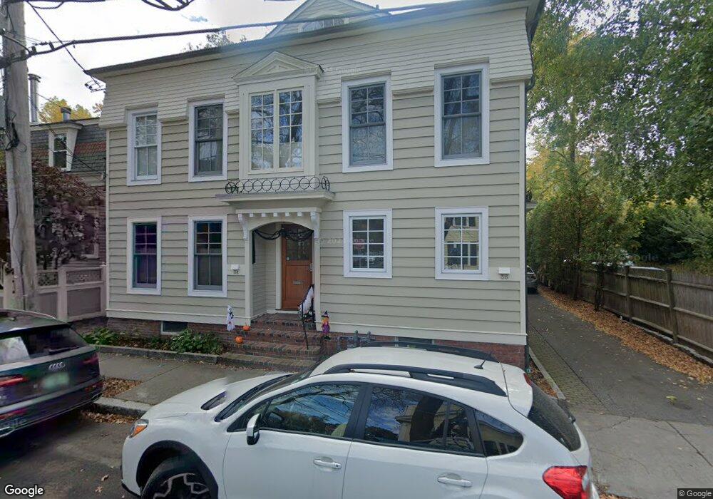
36 Foster St Cambridge, MA 02138
West Cambridge NeighborhoodEstimated Value: $2,555,000 - $3,376,874
7
Beds
6
Baths
3,305
Sq Ft
$907/Sq Ft
Est. Value
About This Home
This home is located at 36 Foster St, Cambridge, MA 02138 and is currently estimated at $2,999,219, approximately $907 per square foot. 36 Foster St is a home located in Middlesex County with nearby schools including St Peter School, Cambridge Montessori School, and Shady Hill School.
Ownership History
Date
Name
Owned For
Owner Type
Purchase Details
Closed on
Nov 17, 2020
Sold by
Hsiao William C
Bought by
W C Hsiao 2016 T
Current Estimated Value
Purchase Details
Closed on
Aug 28, 1997
Sold by
36 Foster St Nt and Cohen Peter L
Bought by
Hsiao William C and Hsiao Ruth Y
Purchase Details
Closed on
Aug 4, 1997
Sold by
Homans Elizabeth G
Bought by
36 Foster St Nt and Cohen Peter L
Create a Home Valuation Report for This Property
The Home Valuation Report is an in-depth analysis detailing your home's value as well as a comparison with similar homes in the area
Home Values in the Area
Average Home Value in this Area
Purchase History
| Date | Buyer | Sale Price | Title Company |
|---|---|---|---|
| W C Hsiao 2016 T | -- | None Available | |
| Hsiao William C | $550,000 | -- | |
| Hsiao William C | $550,000 | -- | |
| 36 Foster St Nt | $400,800 | -- | |
| 36 Foster St Nt | $400,800 | -- |
Source: Public Records
Mortgage History
| Date | Status | Borrower | Loan Amount |
|---|---|---|---|
| Previous Owner | 36 Foster St Nt | $40,000 |
Source: Public Records
Tax History Compared to Growth
Tax History
| Year | Tax Paid | Tax Assessment Tax Assessment Total Assessment is a certain percentage of the fair market value that is determined by local assessors to be the total taxable value of land and additions on the property. | Land | Improvement |
|---|---|---|---|---|
| 2025 | $20,787 | $3,273,600 | $1,568,400 | $1,705,200 |
| 2024 | $18,810 | $3,177,400 | $1,535,600 | $1,641,800 |
| 2023 | $17,249 | $2,943,500 | $1,502,800 | $1,440,700 |
| 2022 | $16,372 | $2,765,600 | $1,464,100 | $1,301,500 |
| 2021 | $15,727 | $2,688,400 | $1,435,700 | $1,252,700 |
| 2020 | $15,038 | $2,615,300 | $1,385,900 | $1,229,400 |
| 2019 | $14,098 | $2,373,400 | $1,215,300 | $1,158,100 |
| 2018 | $14,356 | $2,282,400 | $1,208,200 | $1,074,200 |
| 2017 | $14,369 | $2,214,000 | $1,208,200 | $1,005,800 |
| 2016 | $13,971 | $1,998,700 | $1,062,500 | $936,200 |
| 2015 | $14,146 | $1,809,000 | $977,300 | $831,700 |
| 2014 | $16,812 | $2,006,200 | $888,400 | $1,117,800 |
Source: Public Records
Map
Nearby Homes
- 20 Maynard Place
- 15 Hubbard Park Rd
- 32 Hawthorn St
- 1010 Memorial Dr Unit 6G
- 48 Hubbard Park Rd
- 3 Berkeley Place
- 988 Memorial Dr Unit 386
- 153 Brattle St
- 12 Berkeley St
- 158 Brattle St
- 986 Memorial Dr Unit 404
- 983 Memorial Dr Unit 502
- 984 Memorial Dr Unit 984-503
- 22 Concord Ave Unit 10
- 130 Mount Auburn St Unit 108
- 172 Brattle St
- 44 Garden St
- 52 Garden St Unit B2
- 975 Memorial Dr Unit 209
- 975 Memorial Dr Unit 211
- 34 Foster St
- 30 Foster St
- 46 Foster St
- 28 Foster St
- 30 Bradbury St
- 21 Brown St
- 50 Foster St
- 39 Foster St
- 20 Brown St
- 54 Foster St Unit 54
- 18 Foster St Unit 18
- 18 Foster St
- 14 Foster St
- 32 Bradbury St
- 24B Bradbury St Unit 24B
- 22D Bradbury St Unit 22D
- 45 Foster St
- 22 Bradbury St Unit C
- 24 Bradbury St Unit A
- 24 Bradbury St Unit B