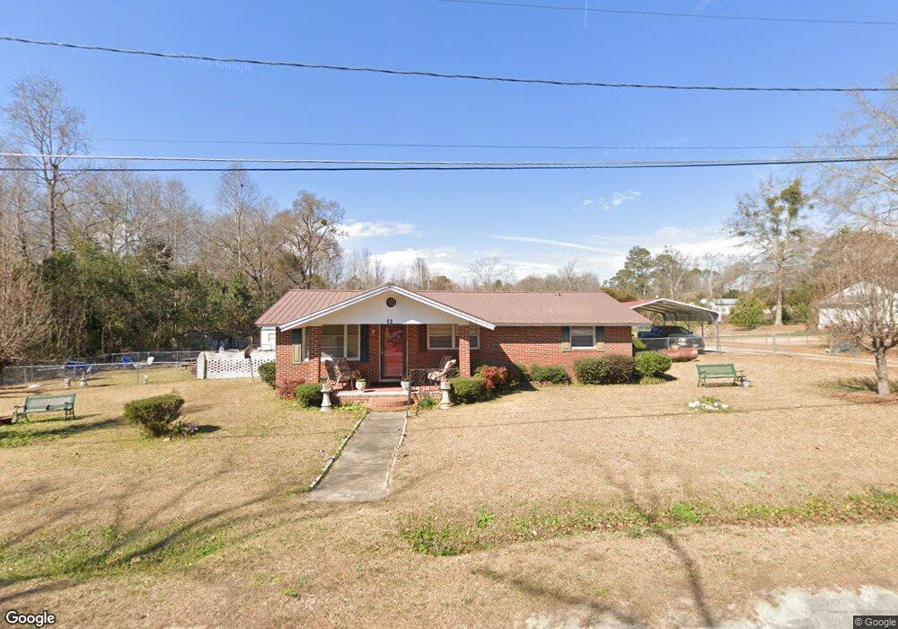
36 Gussie Ave Mc Rae, GA 31055
Estimated Value: $123,878 - $153,000
4
Beds
2
Baths
1,797
Sq Ft
$74/Sq Ft
Est. Value
About This Home
This home is located at 36 Gussie Ave, Mc Rae, GA 31055 and is currently estimated at $133,470, approximately $74 per square foot. 36 Gussie Ave is a home located in Telfair County with nearby schools including Telfair County Elementary School, Telfair County Middle School, and Telfair County High School.
Ownership History
Date
Name
Owned For
Owner Type
Purchase Details
Closed on
Jan 7, 2011
Sold by
Federal Home Loan Mortgage Corporation
Bought by
Wells Thesselesta D
Current Estimated Value
Purchase Details
Closed on
Nov 2, 2010
Sold by
Bank Of Dudley
Bought by
Federal Home Loan Mortgage Corp
Purchase Details
Closed on
Sep 9, 2002
Sold by
Giddens James E
Bought by
Carter Ricky L
Purchase Details
Closed on
Feb 23, 1998
Sold by
Security State Bank
Bought by
Giddens James E
Purchase Details
Closed on
Dec 12, 1997
Sold by
Yawn Faye C
Bought by
Security State Bank
Purchase Details
Closed on
Sep 14, 1992
Bought by
Yawn Faye C
Create a Home Valuation Report for This Property
The Home Valuation Report is an in-depth analysis detailing your home's value as well as a comparison with similar homes in the area
Home Values in the Area
Average Home Value in this Area
Purchase History
| Date | Buyer | Sale Price | Title Company |
|---|---|---|---|
| Wells Thesselesta D | $46,000 | -- | |
| Federal Home Loan Mortgage Corp | -- | -- | |
| Bank Of Dudley | -- | -- | |
| Carter Ricky L | $54,000 | -- | |
| Giddens James E | $48,000 | -- | |
| Security State Bank | -- | -- | |
| Yawn Faye C | -- | -- |
Source: Public Records
Tax History
| Year | Tax Paid | Tax Assessment Tax Assessment Total Assessment is a certain percentage of the fair market value that is determined by local assessors to be the total taxable value of land and additions on the property. | Land | Improvement |
|---|---|---|---|---|
| 2025 | $1,924 | $58,714 | $1,410 | $57,304 |
| 2024 | $1,968 | $53,774 | $1,410 | $52,364 |
| 2023 | $1,859 | $50,966 | $1,410 | $49,556 |
| 2022 | $1,314 | $50,966 | $1,410 | $49,556 |
| 2021 | $835 | $33,624 | $1,410 | $32,214 |
| 2020 | $668 | $27,921 | $1,410 | $26,511 |
| 2019 | $672 | $27,921 | $1,410 | $26,511 |
| 2018 | $1,203 | $27,921 | $1,410 | $26,511 |
| 2017 | $827 | $27,963 | $1,410 | $26,553 |
| 2016 | $827 | $27,963 | $1,410 | $26,553 |
| 2015 | -- | $27,963 | $1,410 | $26,553 |
| 2014 | -- | $28,655 | $1,410 | $27,245 |
| 2013 | -- | $28,655 | $1,410 | $27,245 |
Source: Public Records
Map
Nearby Homes
- 27 E Bruce St
- 47 S First Ave
- 85 E Brewton St
- 0 Bonaire St Unit 10647239
- 0 Bonaire St Unit 23852
- 78 S Second Ave
- 47 Walnut St
- 53 Bonaire Extension
- 136 S Third Ave
- 61 W Bruce St
- 76 E Grant St
- 131 Huckabee St
- 0 Ll350 & 398 7th District Unit 30490
- 95 W Willow Creek Ln
- 177 W Brewton St
- 427 3rd Ave
- 11 Zanders Ave
- 13 Studstill Ln
- 210 W Graham St
- 0 Center Ave Unit 10648464
Your Personal Tour Guide
Ask me questions while you tour the home.