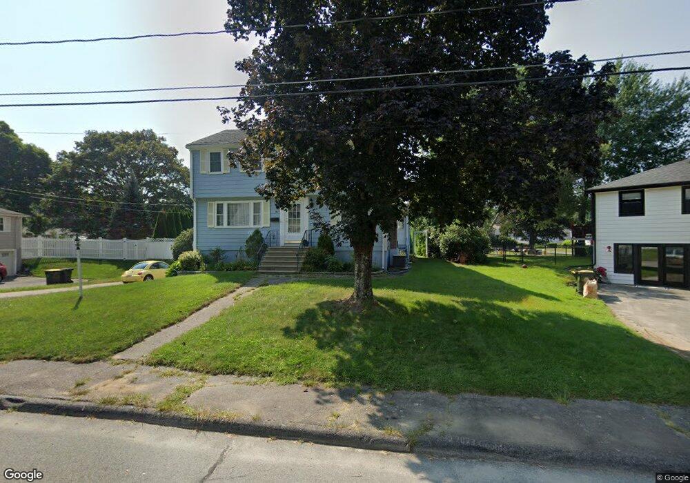
36 Mohawk Path Bellingham, MA 02019
Estimated Value: $542,206 - $617,000
4
Beds
2
Baths
2,067
Sq Ft
$283/Sq Ft
Est. Value
About This Home
This home is located at 36 Mohawk Path, Bellingham, MA 02019 and is currently estimated at $585,052, approximately $283 per square foot. 36 Mohawk Path is a home located in Norfolk County with nearby schools including Stall Brook Elementary School, Bellingham High School, and Bethany Christian Academy.
Ownership History
Date
Name
Owned For
Owner Type
Purchase Details
Closed on
Jan 3, 2023
Sold by
Boles Robert R and Boles Mary O
Bought by
Boles Kevin R and Mcnamara Bridget E
Current Estimated Value
Purchase Details
Closed on
Jun 29, 1994
Sold by
Maniscalco Janice A
Bought by
Boles Robt R and Boles Mary O
Home Financials for this Owner
Home Financials are based on the most recent Mortgage that was taken out on this home.
Original Mortgage
$116,000
Interest Rate
8.55%
Mortgage Type
Purchase Money Mortgage
Create a Home Valuation Report for This Property
The Home Valuation Report is an in-depth analysis detailing your home's value as well as a comparison with similar homes in the area
Home Values in the Area
Average Home Value in this Area
Purchase History
| Date | Buyer | Sale Price | Title Company |
|---|---|---|---|
| Boles Kevin R | -- | None Available | |
| Boles Robt R | $145,000 | -- | |
| Boles Robt R | $145,000 | -- |
Source: Public Records
Mortgage History
| Date | Status | Borrower | Loan Amount |
|---|---|---|---|
| Previous Owner | Boles Robt R | $116,000 |
Source: Public Records
Tax History
| Year | Tax Paid | Tax Assessment Tax Assessment Total Assessment is a certain percentage of the fair market value that is determined by local assessors to be the total taxable value of land and additions on the property. | Land | Improvement |
|---|---|---|---|---|
| 2025 | $5,220 | $415,600 | $165,600 | $250,000 |
| 2024 | $5,008 | $389,400 | $151,200 | $238,200 |
| 2023 | $4,827 | $369,900 | $144,000 | $225,900 |
| 2022 | $4,717 | $335,000 | $120,100 | $214,900 |
| 2021 | $4,592 | $318,700 | $120,100 | $198,600 |
| 2020 | $4,371 | $307,400 | $120,100 | $187,300 |
| 2019 | $4,284 | $301,500 | $120,100 | $181,400 |
| 2018 | $4,005 | $277,900 | $115,500 | $162,400 |
| 2017 | $3,900 | $272,000 | $115,500 | $156,500 |
| 2016 | $3,723 | $260,500 | $113,500 | $147,000 |
| 2015 | $3,568 | $250,400 | $109,200 | $141,200 |
| 2014 | $3,584 | $244,500 | $106,600 | $137,900 |
Source: Public Records
Map
Nearby Homes
- 44 Arapahoe Rd
- 17 Pine St
- 60 Pine St
- 462 Hartford Ave
- 39 West St
- 10 Franklin St
- 22 Granite St
- 276 Pond St
- 6 Freedom Trail
- 15 Fox Run Rd
- 8 Woodhaven Dr
- 6 Kingson Ln Unit 2
- 201 Crossfield Rd
- 4 Shaw St
- 214 Conlyn Ave
- 0 Hixon St Unit 73477486
- 2 Mechanic St Unit 1
- 176 Main St Unit 3
- 8 Riverstone Way
- 5 Richardson St
- 34 Mohawk Path
- 40 Mohawk Path
- 112 Plymouth Rd
- 116 Plymouth Rd
- 32 Mohawk Path
- 39 Mohawk Path
- 37 Mohawk Path
- 109 Plymouth Rd
- 41 Mohawk Path
- 35 Mohawk Path
- 120 Plymouth Rd
- 105 Plymouth Rd
- 33 Mohawk Path
- 113 Plymouth Rd
- 30 Mohawk Path
- 100 Plymouth Rd
- 101 Plymouth Rd
- 117 Plymouth Rd
- 24 Mohawk Path
- 20 Mohawk Path
Your Personal Tour Guide
Ask me questions while you tour the home.