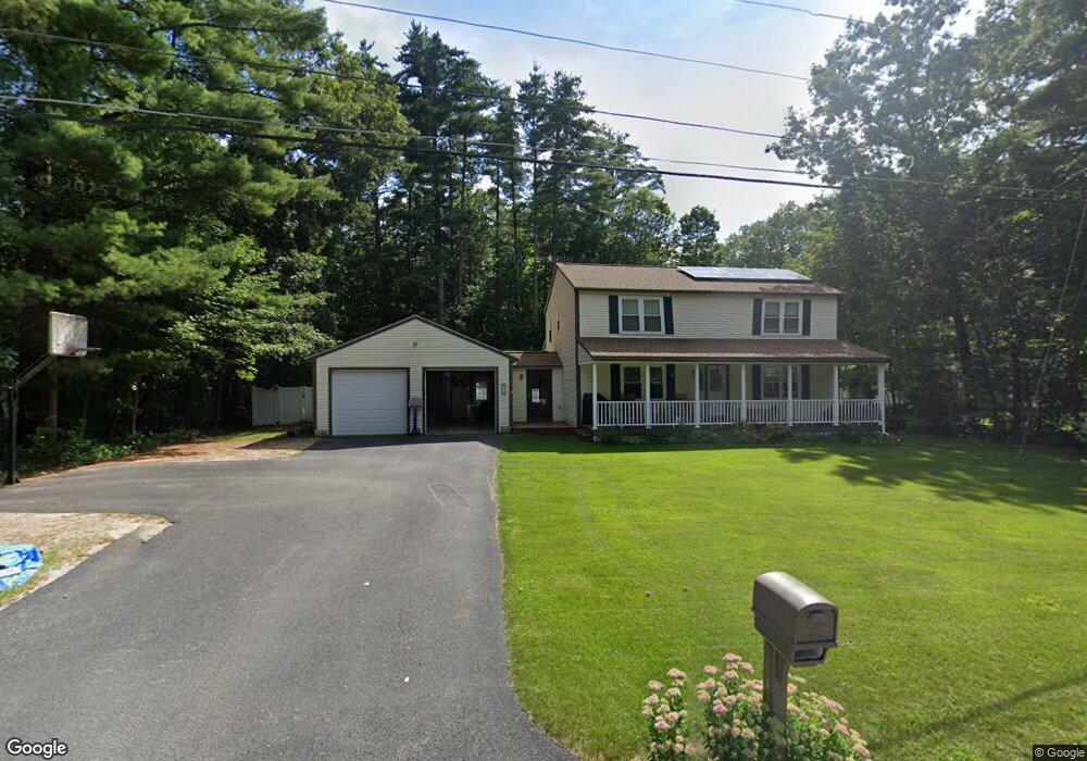
36 N Curtisville Rd Concord, NH 03301
East Concord NeighborhoodEstimated Value: $556,005 - $615,000
4
Beds
3
Baths
1,872
Sq Ft
$313/Sq Ft
Est. Value
About This Home
This home is located at 36 N Curtisville Rd, Concord, NH 03301 and is currently estimated at $586,001, approximately $313 per square foot. 36 N Curtisville Rd is a home located in Merrimack County with nearby schools including Broken Ground School, Rundlett Middle School, and Concord High School.
Ownership History
Date
Name
Owned For
Owner Type
Purchase Details
Closed on
Nov 7, 2024
Sold by
Durso Carl L and Durso Rebecca L
Bought by
Carl Durso Ft and Durso
Current Estimated Value
Purchase Details
Closed on
Aug 11, 1993
Bought by
Durso Carl L and Durso Rebecca L
Create a Home Valuation Report for This Property
The Home Valuation Report is an in-depth analysis detailing your home's value as well as a comparison with similar homes in the area
Home Values in the Area
Average Home Value in this Area
Purchase History
| Date | Buyer | Sale Price | Title Company |
|---|---|---|---|
| Carl Durso Ft | -- | None Available | |
| Durso Carl L | $37,900 | -- |
Source: Public Records
Mortgage History
| Date | Status | Borrower | Loan Amount |
|---|---|---|---|
| Previous Owner | Durso Carl L | $290,230 | |
| Previous Owner | Durso Carl L | $291,000 |
Source: Public Records
Tax History Compared to Growth
Tax History
| Year | Tax Paid | Tax Assessment Tax Assessment Total Assessment is a certain percentage of the fair market value that is determined by local assessors to be the total taxable value of land and additions on the property. | Land | Improvement |
|---|---|---|---|---|
| 2024 | $10,320 | $372,700 | $126,600 | $246,100 |
| 2023 | $9,758 | $363,300 | $126,600 | $236,700 |
| 2022 | $9,406 | $363,300 | $126,600 | $236,700 |
| 2021 | $9,126 | $363,300 | $126,600 | $236,700 |
| 2020 | $8,411 | $314,300 | $91,700 | $222,600 |
| 2019 | $8,267 | $297,600 | $97,900 | $199,700 |
| 2018 | $8,071 | $286,300 | $98,100 | $188,200 |
| 2017 | $7,436 | $263,300 | $81,100 | $182,200 |
| 2016 | $7,377 | $266,600 | $81,100 | $185,500 |
| 2015 | $7,100 | $235,500 | $70,100 | $165,400 |
| 2014 | $6,314 | $235,500 | $70,100 | $165,400 |
| 2013 | -- | $235,500 | $70,100 | $165,400 |
| 2012 | -- | $237,100 | $70,100 | $167,000 |
Source: Public Records
Map
Nearby Homes
- 11 Eastman St
- 2 Shaker Rd
- 61 Mountain Rd
- 32 E Side Dr
- 6 Irving Dr
- 12 E Side Dr Unit 4-13
- 17 Burns Ave Unit 2
- 8 NE Village Rd
- 19 Grappone Dr
- 13 Ellsworth St
- 294 Portsmouth St
- 59 Branch Turnpike
- 43 Branch Turnpike
- 50 Branch Turnpike
- 6 Heights Rd
- 58 Branch Turnpike Unit 26
- 24 Cricket Ln
- 20 Prospect St
- 8-10 Granite Ave
- 1 Guay St
- 34 N Curtisville Rd
- 35 N Curtisville Rd
- 38 N Curtisville Rd
- 32 N Curtisville Rd
- 37 N Curtisville Rd
- 29 N Curtisville Rd
- 40 N Curtisville Rd
- 198 E Side Dr
- 196 E Side Dr
- 95 Portsmouth St
- 27 N Curtisville Rd
- 202 E Side Dr
- 194 E Side Dr
- 99 Portsmouth St
- 42 N Curtisville Rd
- 25 N Curtisville Rd
- 26 N Curtisville Rd
- 41 N Curtisville Rd
- 204 E Side Dr
- 121 Portsmouth St