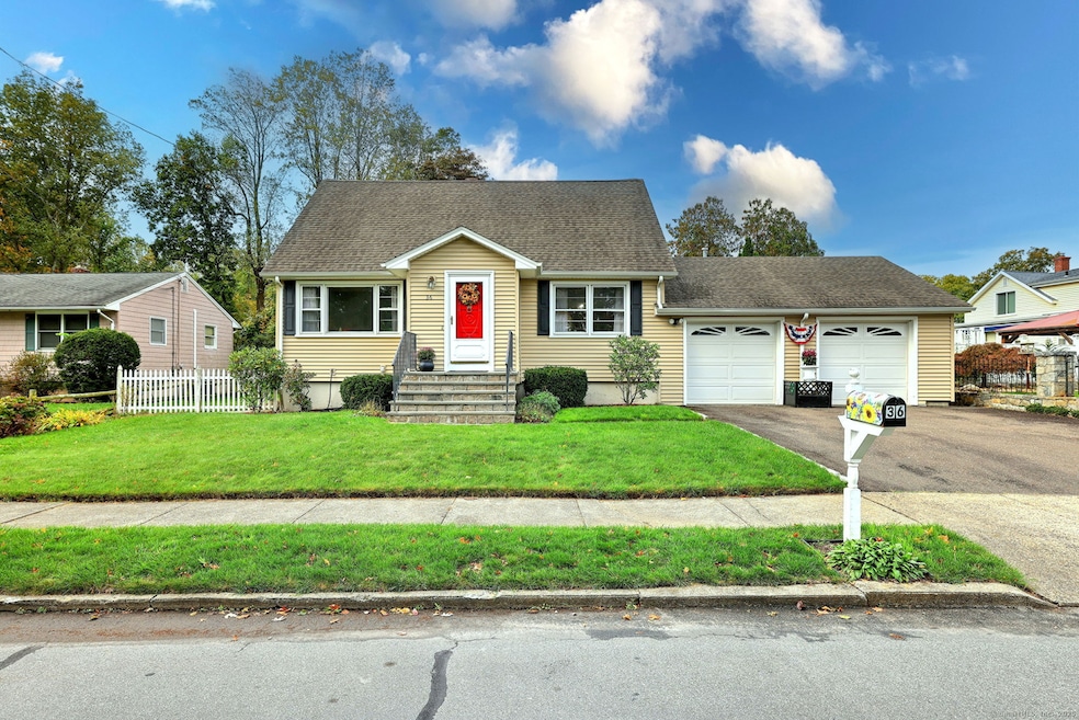
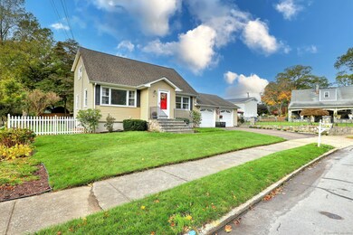
36 Tina Cir Bridgeport, CT 06606
North End NeighborhoodEstimated payment $3,465/month
Highlights
- Cape Cod Architecture
- 1 Fireplace
- Forced Air Zoned Heating and Cooling System
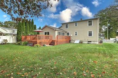
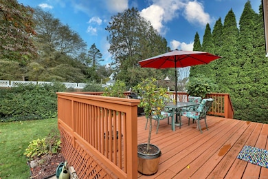
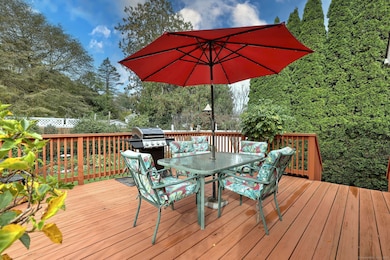
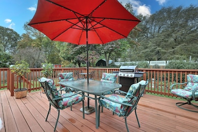
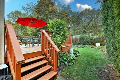
- Deck
- Recessed Lighting
- Property is near shops
About This Home
This spacious and well-maintained Cape Cod-style home is ideally situated on a quiet cul-de-sac less than a mile from Sacred Heart University. Step inside to a welcoming, sun-filled living room, and a generous dining area that opens to the kitchen featuring granite countertops, recessed lighting, abundant counter space, and custom cabinetry. Continue into the inviting family room with a striking stone-faced gas fireplace, and a sliding door that leads to the expansive deck-perfect for relaxing or entertaining. The beautifully landscaped and fenced backyard offers privacy lined with flowering gardens. The main level also includes a bedroom and an updated bathroom with a tiled walk-in shower, granite vanity, and modern tile flooring. Hardwood floors grace the living room, dining room, hallway, and bedroom. Upstairs, the primary bedroom captures sunlight from both the front and rear of the home, features recessed lighting and a double closet with deep storage. The second full bath includes a jetted tub with shower, tile flooring and walls, and a granite-topped vanity. A third bedroom completes this level, with hardwood floors under existing carpeting that extends into the primary bedroom. Additional features include 3-zone heat and the house is generator-ready! Be in reach of SHU, Fairchild Wheeler Golf Course, Discovery Magnet School, Jonathan Winthrop Elementary School, Trumbull Mall and Rte 15 making this North End gem a perfect combination of comfort, convenience, and charm
Listing Agent
Coldwell Banker Realty Brokerage Phone: (203) 691-0919 License #RES. 0827257 Listed on: 10/09/2025

Co-Listing Agent
Coldwell Banker Realty Brokerage Phone: (203) 691-0919 License #RES.0819066
Home Details
Home Type
- Single Family
Est. Annual Taxes
- $8,682
Year Built
- Built in 1966
Lot Details
- 9,148 Sq Ft Lot
- Property is zoned RA
Home Design
- Cape Cod Architecture
- Concrete Foundation
- Frame Construction
- Asphalt Shingled Roof
- Vinyl Siding
Interior Spaces
- 1,830 Sq Ft Home
- Recessed Lighting
- 1 Fireplace
- Basement Fills Entire Space Under The House
Kitchen
- Oven or Range
- Range Hood
- Microwave
- Dishwasher
Bedrooms and Bathrooms
- 3 Bedrooms
- 2 Full Bathrooms
Laundry
- Laundry on lower level
- Dryer
- Washer
Parking
- 2 Car Garage
- Parking Deck
- Automatic Garage Door Opener
- Driveway
Outdoor Features
- Deck
Location
- Property is near shops
- Property is near a bus stop
- Property is near a golf course
Schools
- Winthrop Elementary School
- Blackham Middle School
Utilities
- Forced Air Zoned Heating and Cooling System
- Heating System Uses Natural Gas
Listing and Financial Details
- Assessor Parcel Number 39051
Map
Home Values in the Area
Average Home Value in this Area
Tax History
| Year | Tax Paid | Tax Assessment Tax Assessment Total Assessment is a certain percentage of the fair market value that is determined by local assessors to be the total taxable value of land and additions on the property. | Land | Improvement |
|---|---|---|---|---|
| 2025 | $8,682 | $199,810 | $79,600 | $120,210 |
| 2024 | $8,682 | $199,810 | $79,600 | $120,210 |
| 2023 | $8,682 | $199,810 | $79,600 | $120,210 |
| 2022 | $8,682 | $199,810 | $79,600 | $120,210 |
| 2021 | $8,682 | $199,810 | $79,600 | $120,210 |
| 2020 | $8,536 | $158,100 | $62,350 | $95,750 |
| 2019 | $8,536 | $158,100 | $62,350 | $95,750 |
| 2018 | $8,596 | $158,100 | $62,350 | $95,750 |
| 2017 | $8,596 | $158,100 | $62,350 | $95,750 |
| 2016 | $8,596 | $158,100 | $62,350 | $95,750 |
| 2015 | $7,844 | $185,880 | $61,360 | $124,520 |
| 2014 | $7,844 | $185,880 | $61,360 | $124,520 |
Property History
| Date | Event | Price | List to Sale | Price per Sq Ft |
|---|---|---|---|---|
| 11/11/2025 11/11/25 | Pending | -- | -- | -- |
| 10/18/2025 10/18/25 | For Sale | $520,000 | -- | $284 / Sq Ft |
Purchase History
| Date | Type | Sale Price | Title Company |
|---|---|---|---|
| Warranty Deed | $135,900 | -- | |
| Warranty Deed | $135,900 | -- | |
| Warranty Deed | $125,000 | -- |
Mortgage History
| Date | Status | Loan Amount | Loan Type |
|---|---|---|---|
| Open | $200,000 | No Value Available | |
| Closed | $108,000 | No Value Available | |
| Closed | $108,700 | Unknown |
Source: SmartMLS
MLS Number: 24132028
APN: BRID-002513-000030
Disclaimer: Certain information contained herein is derived from information provided by parties other than Homes.com. All information provided is deemed reliable, but is not guaranteed to be accurate and should be independently verified.
![]() IDX information is provided exclusively for personal, non-commercial use, and may not be used for any purpose other than to identify prospective properties consumers may be interested in purchasing. Information is deemed reliable but not guaranteed.
IDX information is provided exclusively for personal, non-commercial use, and may not be used for any purpose other than to identify prospective properties consumers may be interested in purchasing. Information is deemed reliable but not guaranteed.
- 153 Seaver Cir
- 65 Dobson St
- 64 Dobson St
- 81 Lance Cir
- 44 Lance Cir Unit 44
- 225 Edgemoor Rd Unit H
- 236 Edgemoor Rd Unit D
- 9 Patricia Rd Unit C
- 66 Loftus Cir
- 2955 Madison Ave Unit 40
- 2998 Madison Ave Unit C
- 230 Cherry Hill Dr Unit 1A
- 230 Cherry Hill Dr Unit 2B
- 50 Greenhouse Rd Unit 65D
- 50 Greenhouse Rd Unit 42D
- 50 Greenhouse Rd Unit 42C
- 394 Anton Dr
- 2851 Old Town Rd
- 10 Hitching Post Ln
- 17 Teresa Place Unit 17