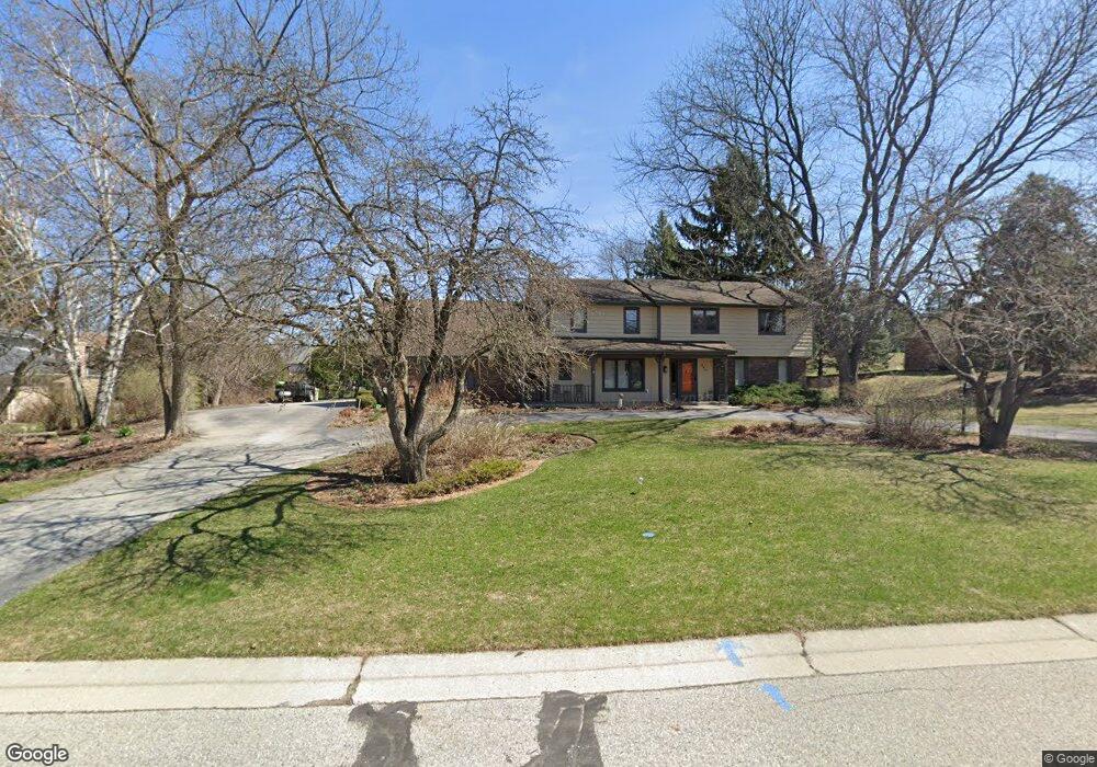
360 Bunker Hill Dr Brookfield, WI 53005
Estimated Value: $744,000 - $806,000
4
Beds
4
Baths
3,135
Sq Ft
$243/Sq Ft
Est. Value
About This Home
This home is located at 360 Bunker Hill Dr, Brookfield, WI 53005 and is currently estimated at $762,652, approximately $243 per square foot. 360 Bunker Hill Dr is a home located in Waukesha County with nearby schools including Swanson Elementary School, Wisconsin Hills Middle School, and Brookfield Central High School.
Ownership History
Date
Name
Owned For
Owner Type
Purchase Details
Closed on
Jun 17, 2020
Sold by
Cairns Thomas C and Cairns Mary T
Bought by
Cairns Joint Trust
Current Estimated Value
Purchase Details
Closed on
Dec 28, 2000
Sold by
Perrott James P and Perrott Hannelore
Bought by
Cairns Thomas C and Cairns Mary T
Home Financials for this Owner
Home Financials are based on the most recent Mortgage that was taken out on this home.
Original Mortgage
$160,000
Interest Rate
7.58%
Mortgage Type
Purchase Money Mortgage
Purchase Details
Closed on
Dec 14, 1999
Sold by
Bjork John T and Cornelius Colleen I
Bought by
Perrott James P and Perrott Hannelore
Home Financials for this Owner
Home Financials are based on the most recent Mortgage that was taken out on this home.
Original Mortgage
$250,000
Interest Rate
7.89%
Mortgage Type
Purchase Money Mortgage
Purchase Details
Closed on
May 20, 1996
Sold by
Bjork Joan E
Bought by
Bjork John T
Create a Home Valuation Report for This Property
The Home Valuation Report is an in-depth analysis detailing your home's value as well as a comparison with similar homes in the area
Home Values in the Area
Average Home Value in this Area
Purchase History
| Date | Buyer | Sale Price | Title Company |
|---|---|---|---|
| Cairns Joint Trust | -- | None Available | |
| Cairns Thomas C | $370,000 | -- | |
| Perrott James P | $346,500 | -- | |
| Bjork John T | -- | -- |
Source: Public Records
Mortgage History
| Date | Status | Borrower | Loan Amount |
|---|---|---|---|
| Previous Owner | Cairns Thomas C | $160,000 | |
| Previous Owner | Perrott James P | $250,000 |
Source: Public Records
Tax History
| Year | Tax Paid | Tax Assessment Tax Assessment Total Assessment is a certain percentage of the fair market value that is determined by local assessors to be the total taxable value of land and additions on the property. | Land | Improvement |
|---|---|---|---|---|
| 2024 | $7,336 | $649,800 | $145,000 | $504,800 |
| 2023 | $7,348 | $649,800 | $145,000 | $504,800 |
| 2022 | $7,801 | $539,000 | $140,000 | $399,000 |
| 2021 | $8,269 | $539,000 | $140,000 | $399,000 |
| 2020 | $8,596 | $539,000 | $140,000 | $399,000 |
| 2019 | $8,268 | $539,000 | $140,000 | $399,000 |
| 2018 | $7,330 | $466,500 | $140,000 | $326,500 |
| 2017 | $7,319 | $466,500 | $140,000 | $326,500 |
| 2016 | $7,425 | $466,500 | $140,000 | $326,500 |
| 2015 | $7,378 | $466,500 | $140,000 | $326,500 |
| 2014 | $7,654 | $466,500 | $140,000 | $326,500 |
| 2013 | $7,654 | $466,500 | $140,000 | $326,500 |
Source: Public Records
Map
Nearby Homes
- 150 Bunker Hill Dr
- 540 Crystal Ln
- 530 Park Cir
- 840 Kurtis Dr
- 920 Madera Cir
- 145 Lynnwood Ln
- 15105 Froedtert Dr
- 738 Elm Grove Rd Unit 738
- 680 Forest Grove Ln
- 13335 Watertown Plank Rd Unit 105
- 1000 Silver Mist Ct
- 14220 Hillside Rd
- 1100 Alfred St
- Lt1 Glory Way
- 1245 Simon Dr
- 1155 Jewel St
- 15330 Huff Way
- 15270 Huff Way
- 1250 Fairhaven Blvd
- 1635 Highland Dr
- 330 Bunker Hill Dr
- 390 Bunker Hill Dr
- 365 Sheffield Dr
- 335 Sheffield Dr
- 300 Bunker Hill Dr
- 395 Sheffield Dr
- 355 Bunker Hill Dr
- 405 Bunker Hill Dr
- 325 Bunker Hill Dr
- 385 Bunker Hill Dr
- 260 Bunker Hill Dr
- 435 Bunker Hill Dr
- 415 Sheffield Dr
- 295 Bunker Hill Dr
- 265 Sheffield Dr
- 14245 Providence Ln
- 360 Concord Dr
- 350 Sheffield Dr
- 320 Concord Dr
- 380 Sheffield Dr
Your Personal Tour Guide
Ask me questions while you tour the home.