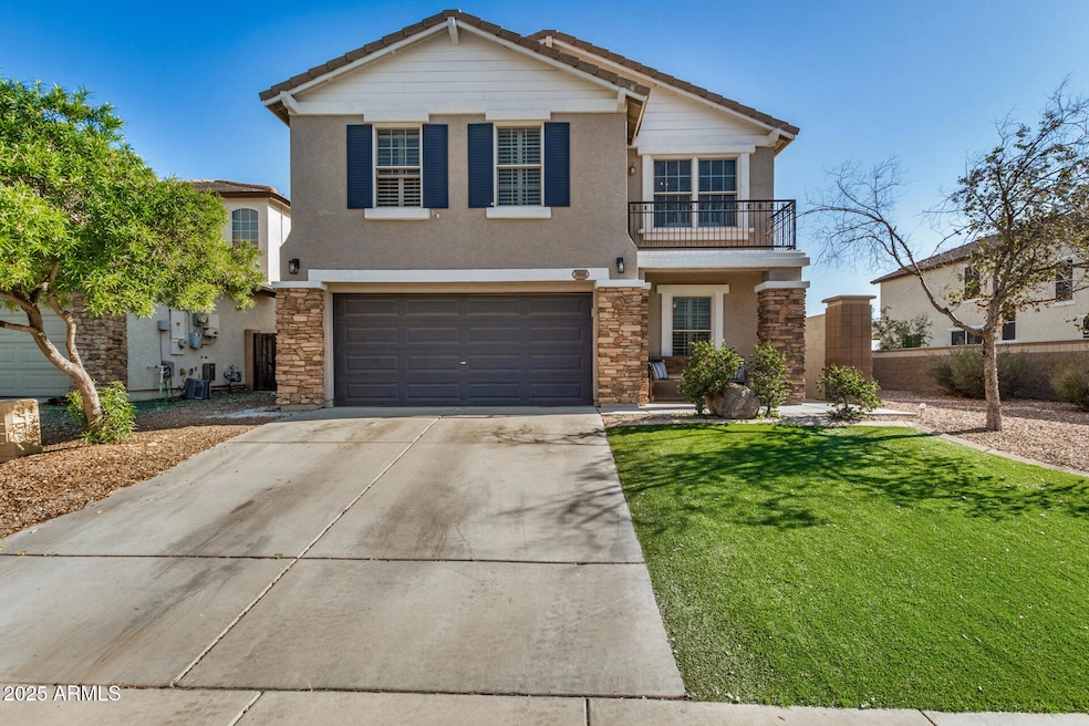
3601 N 292nd Dr Buckeye, AZ 85396
Estimated payment $2,030/month
Highlights
- Mountain View
- Tennis Courts
- 2 Car Direct Access Garage
- Granite Countertops
- Covered Patio or Porch
- Eat-In Kitchen
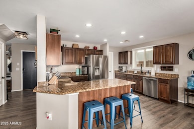
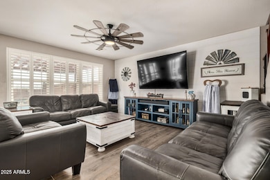
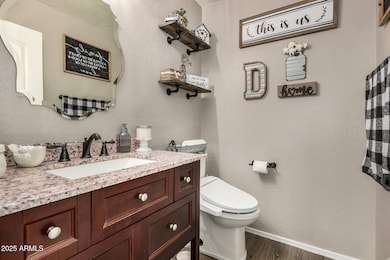
About This Home
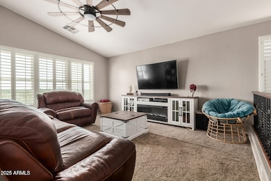
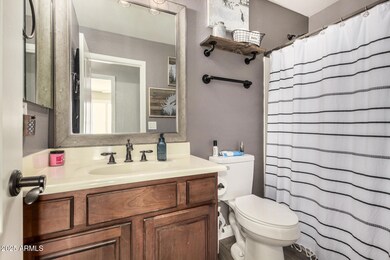
Welcome to this charming Tartesso home featuring 4 bedrooms, an office, a spacious loft, and 2.5 baths—all designed for comfort and flexibility. With only one neighbor to the left, it backs to open desert and borders a peaceful walking path for added privacy. Inside, enjoy inviting farmhouse-inspired touches and a bright kitchen that opens to the dining and living areas. The downstairs office and half bath add convenience, while all bedrooms and full baths are upstairs. The backyard is an entertainer's delight with two custom pergolas, a covered patio, and a cozy firepit. Tartesso offers parks, splash pads, sport courts, and top-notch schools. While the area feels quiet today, exciting development is planned, making this a fantastic place to invest and set up a home.
Listing Agent
My Home Group Real Estate Brokerage Phone: 602-717-0604 License #SA640188000 Listed on: 12/04/2025

Home Details
Home Type
- Single Family
Est. Annual Taxes
- $1,532
Year Built
- Built in 2006
Lot Details
- 5,163 Sq Ft Lot
- Desert faces the front of the property
- East or West Exposure
- Wrought Iron Fence
- Block Wall Fence
- Artificial Turf
HOA Fees
- $87 Monthly HOA Fees
Parking
- 2 Car Direct Access Garage
- Garage Door Opener
Property Views
- Mountain
- Desert
Home Design
- Wood Frame Construction
- Tile Roof
- Stucco
Interior Spaces
- 2,229 Sq Ft Home
- 2-Story Property
- Ceiling Fan
- Double Pane Windows
- Washer and Dryer Hookup
Kitchen
- Eat-In Kitchen
- Breakfast Bar
- Gas Cooktop
- Built-In Microwave
- Granite Countertops
Flooring
- Carpet
- Laminate
Bedrooms and Bathrooms
- 4 Bedrooms
- Primary Bathroom is a Full Bathroom
- 2.5 Bathrooms
- Dual Vanity Sinks in Primary Bathroom
Outdoor Features
- Covered Patio or Porch
Schools
- Tartesso Elementary School
- Ruth Fisher Middle School
- Tonopah Valley High School
Utilities
- Cooling Available
- Heating System Uses Natural Gas
- Cable TV Available
Listing and Financial Details
- Tax Lot 48
- Assessor Parcel Number 504-07-060
Community Details
Overview
- Association fees include ground maintenance
- Kinney Management Association, Phone Number (480) 820-3451
- Built by Trend Homes
- Tartesso Unit 1 Amd Subdivision
Recreation
- Tennis Courts
- Community Playground
- Bike Trail
Map
Home Values in the Area
Average Home Value in this Area
Tax History
| Year | Tax Paid | Tax Assessment Tax Assessment Total Assessment is a certain percentage of the fair market value that is determined by local assessors to be the total taxable value of land and additions on the property. | Land | Improvement |
|---|---|---|---|---|
| 2025 | $1,532 | $12,041 | -- | -- |
| 2024 | $1,294 | $11,468 | -- | -- |
| 2023 | $1,294 | $24,080 | $4,810 | $19,270 |
| 2022 | $1,280 | $18,360 | $3,670 | $14,690 |
| 2021 | $1,190 | $15,720 | $3,140 | $12,580 |
| 2020 | $1,170 | $14,770 | $2,950 | $11,820 |
| 2019 | $1,159 | $14,260 | $2,850 | $11,410 |
| 2018 | $1,127 | $12,350 | $2,470 | $9,880 |
| 2017 | $1,133 | $11,480 | $2,290 | $9,190 |
| 2016 | $576 | $11,210 | $2,240 | $8,970 |
| 2015 | $1,103 | $10,600 | $2,120 | $8,480 |
Property History
| Date | Event | Price | List to Sale | Price per Sq Ft |
|---|---|---|---|---|
| 12/04/2025 12/04/25 | For Sale | $345,000 | -- | $155 / Sq Ft |
Purchase History
| Date | Type | Sale Price | Title Company |
|---|---|---|---|
| Warranty Deed | $93,900 | Pioneer Title Agency Inc | |
| Special Warranty Deed | $205,944 | Chicago Title Insurance Co | |
| Cash Sale Deed | $2,546,725 | First American Title |
Mortgage History
| Date | Status | Loan Amount | Loan Type |
|---|---|---|---|
| Open | $91,519 | FHA | |
| Previous Owner | $205,900 | New Conventional |
Source: Arizona Regional Multiple Listing Service (ARMLS)
MLS Number: 6954297
APN: 504-07-060
Disclaimer: Certain information contained herein is derived from information provided by parties other than Homes.com. All information provided is deemed reliable, but is not guaranteed to be accurate and should be independently verified.
![]() All information should be verified by the recipient and none is guaranteed as accurate by ARMLS
All information should be verified by the recipient and none is guaranteed as accurate by ARMLS
Listing Information presented by local MLS brokerage: Ten-X, local REALTOR®- Arlene Richardson - (888)-952-6393
- 3652 N 292nd Dr
- 3763 N 292nd Ln
- 29235 W Clarendon Ave
- 29412 W Whitton Ave
- 29402 W Mitchell Ave
- 29377 W Clarendon Ave
- 29441 W Mitchell Ave
- 3811 N 295th Ave
- 29488 W Columbus Ave
- 3885 N 294th Ln
- 29539 W Whitton Ave
- 29673 W Columbus Ave
- 29724 W Whitton Ave
- 29691 W Amelia Ave
- 29779 W Whitton Ave
- 29729 W Fairmount Ave
- O N Vacant Land --
- 3706 N 298th Ave
- 29882 W Brindley Ave
- 681 N Bruner Rd
- 3792 N 297th Ave
- 30012 W Monterey Dr
- 2965 N 303rd Dr
- 30365 W Catalina Dr Unit 2A
- 952 S 305th Ave
- 3690 N 308th Ln
- 3616 N 308th Ln
- 30945 W Picadilly Rd
- 30962 W Cheery Lynn Rd
- 31009 W Columbus Ave
- 31027 W Mulberry Dr
- 31040 W Whitton Ave
- 31065 W Monterey Ave
- 25805 W Kendall St
- 26064 W Superior Ave
- 25753 W Winslow Ave
- 25707 W Williams Ct
- 3047 S 257th Ave
- 25524 W Williams St
- 25550 W Pioneer St