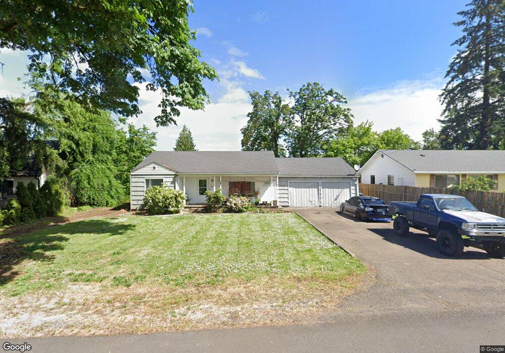
3609 Sisters View Ave Eugene, OR 97401
Harlow NeighborhoodEstimated Value: $427,000 - $458,000
3
Beds
1
Bath
1,225
Sq Ft
$360/Sq Ft
Est. Value
About This Home
This home is located at 3609 Sisters View Ave, Eugene, OR 97401 and is currently estimated at $440,575, approximately $359 per square foot. 3609 Sisters View Ave is a home located in Lane County with nearby schools including Holt Elementary School, Monroe Middle School, and Sheldon High School.
Ownership History
Date
Name
Owned For
Owner Type
Purchase Details
Closed on
May 11, 1998
Sold by
Ream Merle and Keating Beverly
Bought by
Carothers Ii Wallace D and Carothers Holly D
Current Estimated Value
Home Financials for this Owner
Home Financials are based on the most recent Mortgage that was taken out on this home.
Original Mortgage
$114,000
Interest Rate
7.13%
Mortgage Type
Seller Take Back
Create a Home Valuation Report for This Property
The Home Valuation Report is an in-depth analysis detailing your home's value as well as a comparison with similar homes in the area
Home Values in the Area
Average Home Value in this Area
Purchase History
| Date | Buyer | Sale Price | Title Company |
|---|---|---|---|
| Carothers Ii Wallace D | $124,000 | Key Title Company |
Source: Public Records
Mortgage History
| Date | Status | Borrower | Loan Amount |
|---|---|---|---|
| Closed | Carothers Ii Wallace D | $114,000 |
Source: Public Records
Tax History
| Year | Tax Paid | Tax Assessment Tax Assessment Total Assessment is a certain percentage of the fair market value that is determined by local assessors to be the total taxable value of land and additions on the property. | Land | Improvement |
|---|---|---|---|---|
| 2025 | $3,876 | $198,931 | -- | -- |
| 2024 | $3,828 | $193,137 | -- | -- |
| 2023 | $3,828 | $187,512 | $0 | $0 |
| 2022 | $3,586 | $182,051 | $0 | $0 |
| 2021 | $3,368 | $176,749 | $0 | $0 |
| 2020 | $3,380 | $171,601 | $0 | $0 |
| 2019 | $3,264 | $166,603 | $0 | $0 |
| 2018 | $3,073 | $157,040 | $0 | $0 |
| 2017 | $2,935 | $157,040 | $0 | $0 |
| 2016 | $2,862 | $152,466 | $0 | $0 |
| 2015 | $2,759 | $148,025 | $0 | $0 |
| 2014 | $2,672 | $143,714 | $0 | $0 |
Source: Public Records
Map
Nearby Homes
- 446 Kodiak St
- 3579 Oxbow Way
- 3460 Oxbow Way
- 825 Waverly St
- 1038 President St
- 2994 Dapple Way
- 341 Ransom Ct
- 3700 Babcock Ln Unit 119
- 3700 Babcock Ln Unit 106
- 280 Regal Ct
- 2872 Suffolk Ct
- 898 Lochaven Ave
- 1271 Arcadia Dr
- 375 Mia Ln
- 1270 Calvin St
- 2746 Harlow Rd
- 2727 Gateway St Unit 27
- 1130 Anderson Ln
- 600 Cherry Dr Unit 8
- 3025 Bailey Ln
- 3584 Hickory Ave
- 3585 Sisters View Ave
- 3635 Sisters View Ave
- 3570 Hickory Ave
- 3575 Sisters View Ave
- 3637 Sisters View Ave
- 3566 Hickory Ave
- 3590 Hickory Ave
- 0 Sisters View Ave
- 3575 Hickory Ave
- 3585 Hickory Ave
- 3596 Sisters View Ave
- 3592 Sisters View Ave
- 3634 Sisters View Ave
- 3675 Sisters View Ave
- 3620 Hickory Ave
- 505 Sweet Gum Ln
- 3544 Hickory Ave
- 3595 Hickory Ave
- 0 Hickory Ave Unit 4102 20419439
Your Personal Tour Guide
Ask me questions while you tour the home.