Estimated Value: $345,000 - $380,840
4
Beds
3
Baths
1,162
Sq Ft
$314/Sq Ft
Est. Value
About This Home
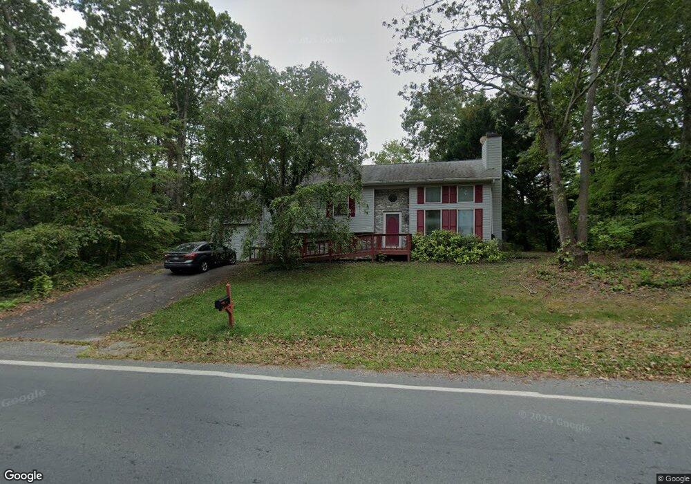
This home is located at 361 Thunderbird Dr, Lusby, MD 20657 and is currently estimated at $364,960, approximately $314 per square foot. 361 Thunderbird Dr is a home located in Calvert County with nearby schools including Patuxent Appeal Elementary Campus, Mill Creek Middle School, and Patuxent High School.
Ownership History
Date
Name
Owned For
Owner Type
Purchase Details
Closed on
Mar 23, 2010
Sold by
Axtell Keith W
Bought by
Westgate David P and Westgate Patricia E
Current Estimated Value
Purchase Details
Closed on
May 7, 2002
Sold by
Linassi Thomas W and Linassi Jeannette D
Bought by
Axtell Keith W
Purchase Details
Closed on
Aug 3, 2000
Sold by
Strickler Craig A and Strickler Constance E
Bought by
Linassi Thomas W and Linassi Jeannette D
Create a Home Valuation Report for This Property
The Home Valuation Report is an in-depth analysis detailing your home's value as well as a comparison with similar homes in the area
Home Values in the Area
Average Home Value in this Area
Purchase History
| Date | Buyer | Sale Price | Title Company |
|---|---|---|---|
| Westgate David P | $214,000 | -- | |
| Axtell Keith W | $151,000 | -- | |
| Linassi Thomas W | $136,700 | -- |
Source: Public Records
Mortgage History
| Date | Status | Borrower | Loan Amount |
|---|---|---|---|
| Closed | Westgate David P | -- |
Source: Public Records
Tax History Compared to Growth
Tax History
| Year | Tax Paid | Tax Assessment Tax Assessment Total Assessment is a certain percentage of the fair market value that is determined by local assessors to be the total taxable value of land and additions on the property. | Land | Improvement |
|---|---|---|---|---|
| 2025 | $3,172 | $283,433 | $0 | $0 |
| 2024 | $3,172 | $253,967 | $0 | $0 |
| 2023 | $2,487 | $224,500 | $55,200 | $169,300 |
| 2022 | $2,271 | $218,533 | $0 | $0 |
| 2021 | $5,393 | $212,567 | $0 | $0 |
| 2020 | $1,664 | $206,600 | $55,200 | $151,400 |
| 2019 | $2,107 | $200,833 | $0 | $0 |
| 2018 | $2,046 | $195,067 | $0 | $0 |
| 2017 | $2,387 | $189,300 | $0 | $0 |
| 2016 | -- | $189,300 | $0 | $0 |
| 2015 | $2,887 | $189,300 | $0 | $0 |
| 2014 | $2,887 | $191,700 | $0 | $0 |
Source: Public Records
Map
Nearby Homes
- 383 Red Cloud Rd
- 389 Thunderbird Dr
- 12361 Silver Rock Cir
- 11722 Big Bear Ln
- 11615 Big Bear Ln
- 11616 Deadwood Dr
- 542 Chisholm Trail
- 11609 Deadwood Dr
- 12516 Olivet Rd
- 634 Silver Rock Rd
- 285 Red Cloud Rd
- 513 Cody Trail
- 291 Red Cloud Rd
- 646 White Rock Rd
- 513 Bridle Ct
- 12609 Olivet Rd
- 502 Dodge Trail
- 232 Thunderbird Dr
- 11590 Durango Dr
- 228 Thunderbird Dr
- 11954 Hemlock Rd
- 365 Thunderbird Dr
- 11959 Pine Trail
- 11953 Hemlock Rd
- 11949 Hemlock Rd
- 11958 Hemlock Rd
- 369 Thunderbird Dr
- 11961 Pine Trail
- 11900 Six Gun Cir
- 11870 Highview Cir
- 11901 Six Gun Cir
- 11962 Hemlock Rd
- 11957 Hemlock Rd
- 351 Thunderbird Dr
- 11965 Pine Trail
- 11869 Highview Cir
- 366 Cedar Ln
- 11956 Pine Trail
- 11904 Six Gun Cir
- 11866 Highview Cir