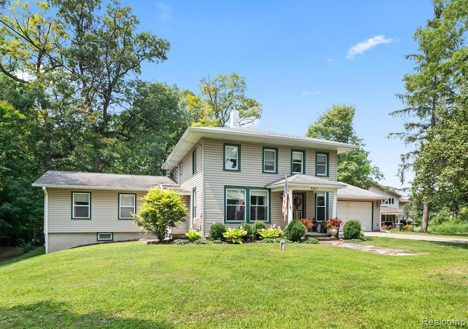


3611 N M 52 Owosso, MI 48867
Estimated payment $1,985/month
Highlights
- River Access
- No HOA
- 2.5 Car Attached Garage
- Farmhouse Style Home
- Bar Fridge
- Tankless Water Heater
About This Home
Welcome to 3611 N M-52 Highway, an updated country retreat with modern comforts and expansive space inside and out.
Set on a generous lot just north of town, this property greets you with impressive curb appeal, a spacious front yard, and a large heated pole barn, perfect for hobbies, storage, or a home-based business. Aerial views reveal the property’s privacy, mature trees, and open green space, ideal for outdoor living.
Inside, the home has been thoughtfully updated with new vinyl flooring throughout, fresh upstairs flooring, and a recently finished bonus room. The kitchen shines with new countertops, a tasteful backsplash, a kitchen bar, and a brand-new sink flowing seamlessly into the spacious dining and living areas, perfect for entertaining.
The primary suite features a walk-in closet and a large bathroom, while the big pantry and partially finished basement add versatile storage and living space. Upgrades include a tankless water heater (2023), water softener (2023), newer septic, and a flat roof replaced in 2022 with transferable warranty. Cozy up by the wood burner in cooler months or relax on the spacious patio in warmer weather.
The property also boasts a large garage, a plum tree, and propane-heated pole barn (leased tank).

Home Details
Home Type
- Single Family
Est. Annual Taxes
Year Built
- Built in 1860
Lot Details
- 2 Acre Lot
- Lot Dimensions are 84x584
Parking
- 2.5 Car Attached Garage
Home Design
- Farmhouse Style Home
- Asphalt Roof
- Vinyl Construction Material
Interior Spaces
- 2,098 Sq Ft Home
- 3-Story Property
- Bar Fridge
- Ceiling Fan
Kitchen
- Built-In Electric Oven
- Electric Cooktop
- Range Hood
- Recirculated Exhaust Fan
- Microwave
- Dishwasher
- Disposal
Bedrooms and Bathrooms
- 4 Bedrooms
- 2 Full Bathrooms
Laundry
- Dryer
- Washer
Partially Finished Basement
- Crawl Space
- Basement Window Egress
Utilities
- Window Unit Cooling System
- Forced Air Heating System
- Heating System Uses Natural Gas
- Tankless Water Heater
Additional Features
- River Access
- Ground Level
Community Details
- No Home Owners Association
- Laundry Facilities
Listing and Financial Details
- Assessor Parcel Number 0023610001000
Map
Home Values in the Area
Average Home Value in this Area
Tax History
| Year | Tax Paid | Tax Assessment Tax Assessment Total Assessment is a certain percentage of the fair market value that is determined by local assessors to be the total taxable value of land and additions on the property. | Land | Improvement |
|---|---|---|---|---|
| 2025 | $2,539 | $106,000 | $0 | $0 |
| 2024 | $2,539 | $89,200 | $0 | $0 |
| 2023 | $2,422 | $91,200 | $0 | $0 |
| 2022 | $2,278 | $89,100 | $0 | $0 |
| 2021 | $2,278 | $76,800 | $0 | $0 |
| 2020 | $831 | $71,500 | $0 | $0 |
| 2019 | $845 | $70,800 | $0 | $0 |
| 2018 | $2,308 | $71,000 | $0 | $0 |
| 2017 | $1,925 | $73,200 | $0 | $0 |
| 2016 | -- | $73,200 | $0 | $0 |
| 2015 | -- | $71,900 | $0 | $0 |
| 2014 | -- | $70,300 | $0 | $0 |
Property History
| Date | Event | Price | List to Sale | Price per Sq Ft |
|---|---|---|---|---|
| 08/08/2025 08/08/25 | For Sale | $335,000 | -- | $160 / Sq Ft |
Purchase History
| Date | Type | Sale Price | Title Company |
|---|---|---|---|
| Warranty Deed | $159,900 | -- |
Mortgage History
| Date | Status | Loan Amount | Loan Type |
|---|---|---|---|
| Open | $127,920 | New Conventional |
Source: Realcomp
MLS Number: 20251025407
APN: 002-36-100-010
Disclaimer: Certain information contained herein is derived from information provided by parties other than Homes.com. All information provided is deemed reliable, but is not guaranteed to be accurate and should be independently verified.
![]() IDX provided courtesy of Realcomp II Ltd. via Ten-X and MLS
IDX provided courtesy of Realcomp II Ltd. via Ten-X and MLS
Copyright 2025 Realcomp II Ltd. Shareholders
IDX information is provided exclusively for consumers' personal, noncommercial use and may not be used for any purpose other than to identify prospective properties consumers may be interested in purchasing. The accuracy of all information, regardless of source, is not guaranteed or warranted. All information should be independently verified.
Listing Information presented by local MLS brokerage: Ten-X, local REALTOR®- Arlene Richardson - (888)-952-6393
- 3999 N Chipman Rd
- 502 Dean Dr
- 2015 Sunset Dr
- 700 Curwood Rd
- 5531 N Chipman St
- 1588 N Chipman Rd
- 205 E Main
- 914 Chipman Ln
- 1217 Hanover St
- 1406 Buckley Dr
- 1104 Riverside Dr
- 1473 Mallard Cir
- 1301 Whitehaven Ct
- 1430 Mallard Cir
- 705 Campbell Dr
- 1004 N Ball St
- 930 Pine St
- 916 N Shiawassee St
- 921 Dingwall Dr
- 917 N Hickory St
- 411 N Chipman St
- 326 N Washington St Unit 4
- 1850 Babcock St
- 219 Cleveland Ave
- 1804 James Ave Unit 1
- 800 Riverwalk Cir
- 601 S Norton St
- 150-158 Meadowwood Ln
- 7762 M-71
- 312 N Oak St
- 10380 E Lansing Rd Unit 10380
- 529 E 2nd St
- 152 N Washington St
- 300 Henry Ct
- 320 Terrace Dr
- 5034 N Mckinley Rd
- 99 Sheppard Ave Unit 99
- 286 Clark St
- 5802 Bath Rd Unit 1
- 204 Borman Ave Unit 204