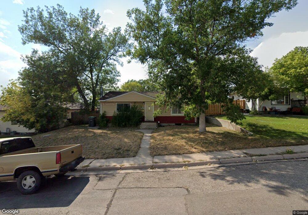
3618 Amherst Rd Cheyenne, WY 82001
Estimated Value: $309,000 - $366,000
--
Bed
--
Bath
864
Sq Ft
$381/Sq Ft
Est. Value
About This Home
This home is located at 3618 Amherst Rd, Cheyenne, WY 82001 and is currently estimated at $329,185, approximately $381 per square foot. 3618 Amherst Rd is a home located in Laramie County with nearby schools including Henderson Elementary School, Carey Junior High School, and East High School.
Ownership History
Date
Name
Owned For
Owner Type
Purchase Details
Closed on
Sep 29, 2006
Sold by
Ashley Jerome L
Bought by
Kelly Meghan
Current Estimated Value
Home Financials for this Owner
Home Financials are based on the most recent Mortgage that was taken out on this home.
Original Mortgage
$141,075
Outstanding Balance
$84,415
Interest Rate
6.51%
Mortgage Type
Purchase Money Mortgage
Estimated Equity
$244,770
Purchase Details
Closed on
Jun 28, 2000
Sold by
Rodekohr Carl W and Rodekohr Deborah L
Bought by
Ashley Jerome and Ashley Caroline
Create a Home Valuation Report for This Property
The Home Valuation Report is an in-depth analysis detailing your home's value as well as a comparison with similar homes in the area
Home Values in the Area
Average Home Value in this Area
Purchase History
| Date | Buyer | Sale Price | Title Company |
|---|---|---|---|
| Kelly Meghan | -- | None Available | |
| Ashley Jerome | -- | -- |
Source: Public Records
Mortgage History
| Date | Status | Borrower | Loan Amount |
|---|---|---|---|
| Open | Kelly Meghan | $141,075 |
Source: Public Records
Tax History Compared to Growth
Tax History
| Year | Tax Paid | Tax Assessment Tax Assessment Total Assessment is a certain percentage of the fair market value that is determined by local assessors to be the total taxable value of land and additions on the property. | Land | Improvement |
|---|---|---|---|---|
| 2025 | $1,630 | $17,978 | $3,035 | $14,943 |
| 2024 | $1,630 | $23,050 | $4,047 | $19,003 |
| 2023 | $1,661 | $23,487 | $4,047 | $19,440 |
| 2022 | $1,433 | $19,847 | $4,047 | $15,800 |
| 2021 | $1,362 | $18,826 | $4,047 | $14,779 |
| 2020 | $1,205 | $16,708 | $4,047 | $12,661 |
| 2019 | $1,174 | $16,267 | $4,047 | $12,220 |
| 2018 | $1,060 | $14,827 | $3,737 | $11,090 |
| 2017 | $1,056 | $14,628 | $3,737 | $10,891 |
| 2016 | $991 | $13,726 | $3,556 | $10,170 |
| 2015 | $931 | $12,894 | $3,556 | $9,338 |
| 2014 | $965 | $13,281 | $3,556 | $9,725 |
Source: Public Records
Map
Nearby Homes
- 3561 Amherst Rd
- 1502 Andover Dr
- 3561 Boston Rd
- 1210 E 5th Ave
- 3533 Duff Ave
- 1770 Andover Dr
- 1120 Black Ct
- 1763 Milton Dr
- 1214 E 23rd St
- 2114 Rollins Ave
- 1859 Cheshire Dr
- 1847 Milton Dr
- 1208 E 22nd St
- 3700 Essex Rd
- 1115 E 23rd St
- 2013 Dunn Ave
- 1100 E 22nd St
- 1958 Newton Dr
- 1920 E 22nd St
- 2004 E 22nd St
- 3624 Amherst Rd
- 3612 Amherst Rd
- 3608 Amherst Rd
- 3619 Dunn Ave
- 3615 Dunn Ave
- 3611 Dunn Ave
- 3623 Dunn Ave
- 1414 E 3rd Ave
- 3634 Amherst Rd
- 3629 Dunn Ave
- 3553 Amherst Rd
- 3549 Amherst Rd
- 3545 Amherst Rd
- 3565 Amherst Rd
- 3601 Dunn Ave
- 3633 Dunn Ave
- 3539 Amherst Rd
- 3569 Amherst Rd
- 3533 Amherst Rd
- 3530 Amherst Rd