Estimated Value: $700,000 - $1,150,000
4
Beds
3
Baths
2,412
Sq Ft
$379/Sq Ft
Est. Value
About This Home
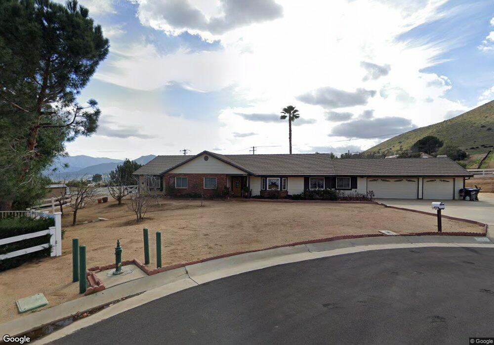
This home is located at 3624 Lariat Way, Acton, CA 93510 and is currently estimated at $914,693, approximately $379 per square foot. 3624 Lariat Way is a home located in Los Angeles County with nearby schools including High Desert School, Meadowlark Elementary School, and Vasquez High School.
Ownership History
Date
Name
Owned For
Owner Type
Purchase Details
Closed on
Nov 27, 1996
Sold by
Commonwealth Life Insurance Co
Bought by
Lammon Larry S
Current Estimated Value
Home Financials for this Owner
Home Financials are based on the most recent Mortgage that was taken out on this home.
Original Mortgage
$186,400
Outstanding Balance
$16,360
Interest Rate
7.59%
Estimated Equity
$898,334
Purchase Details
Closed on
Aug 21, 1996
Sold by
Hayes William R and Hayes Kathleen M
Bought by
Commonwealth Life Insurance Company
Create a Home Valuation Report for This Property
The Home Valuation Report is an in-depth analysis detailing your home's value as well as a comparison with similar homes in the area
Home Values in the Area
Average Home Value in this Area
Purchase History
We collect this data history from publicly available records. To have your information removed, we recommend requesting removal directly through your county’s website.
| Date | Buyer | Sale Price | Title Company |
|---|---|---|---|
| Lammon Larry S | $233,000 | -- | |
| Commonwealth Life Insurance Company | $229,000 | American Title |
Source: Public Records
Mortgage History
We collect this data history from publicly available records. To have your information removed, we recommend requesting removal directly through your county’s website.
| Date | Status | Borrower | Loan Amount |
|---|---|---|---|
| Open | Lammon Larry S | $186,400 |
Source: Public Records
Tax History
| Year | Tax Paid | Tax Assessment Tax Assessment Total Assessment is a certain percentage of the fair market value that is determined by local assessors to be the total taxable value of land and additions on the property. | Land | Improvement |
|---|---|---|---|---|
| 2025 | $5,488 | $417,089 | $135,169 | $281,920 |
| 2024 | $5,213 | $408,912 | $132,519 | $276,393 |
| 2023 | $4,994 | $400,895 | $129,921 | $270,974 |
| 2022 | $4,911 | $393,035 | $127,374 | $265,661 |
| 2021 | $4,820 | $385,329 | $124,877 | $260,452 |
| 2020 | $4,752 | $381,379 | $123,597 | $257,782 |
| 2019 | $4,694 | $373,902 | $121,174 | $252,728 |
| 2018 | $4,469 | $366,572 | $118,799 | $247,773 |
| 2016 | $4,184 | $352,339 | $114,187 | $238,152 |
| 2015 | $4,111 | $347,047 | $112,472 | $234,575 |
| 2014 | $4,059 | $340,249 | $110,269 | $229,980 |
Source: Public Records
Map
Nearby Homes
- 3621 Silver Spur Ln
- 0 Sourdough Rd
- 33805 Crown Valley Rd
- 0 Sourdough Rd Vic Hypotenuse Unit 25003654
- 3943 Sierra Hwy
- 0 Clanfield Street Crown Valle Unit 25006999
- 0 Governor Mine Rd Unit SR26052445
- 0 E Sierra Hwy Unit OC25202614
- 0 Hypotenuse Vacant Land Rd
- 33218 Acklins Ave
- 0 Vac Sierra Hwy and Hypotenuse Hwy Unit 25008269
- 0 N Hypotenuse Rd Unit 26001310
- 0 N Hypotenuse Rd Unit SR26034233
- 0 Vic Governor Mine Rd Cro Rd Unit 26002019
- 0 Pelona Canyon Rd
- 0 Vac Cor Soledad Canyon R Unit 25585671
- 34590 Brock Ln
- 33011 Crown Valley Rd
- 0 Acklins Ave
- 2807 Clanfield St
- 3606 Lariat Way
- 3623 Lariat Way
- 34043 Crown Valley Rd
- 3611 Lariat Way
- 3550 Lariat Way
- 34013 Crown Valley Rd
- 3533 Lariat Way
- 3622 Silver Spur Ln
- 3528 Lariat Way
- 3809 Sourdough Rd
- 3612 Silver Spur Ln
- 3833 Sourdough Rd
- 3527 Lariat Way
- 3530 Silver Spur Ln
- 0 Kalman St Vic 28 Stw Unit 21003130
- 0 Kalman St Vic 28 Stw Unit 21003124
- 34113 Crown Valley Rd
- 34111 Crown Valley Rd
- 3808 Sourdough Rd
- 3905 Sourdough Rd
Your Personal Tour Guide
Ask me questions while you tour the home.