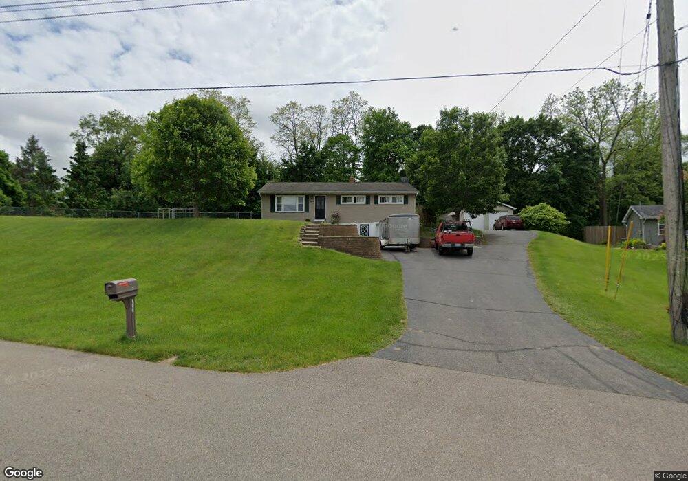
363 Beaumont Dr Battle Creek, MI 49014
Estimated Value: $207,000 - $243,000
3
Beds
2
Baths
1,444
Sq Ft
$155/Sq Ft
Est. Value
About This Home
This home is located at 363 Beaumont Dr, Battle Creek, MI 49014 and is currently estimated at $224,232, approximately $155 per square foot. 363 Beaumont Dr is a home located in Calhoun County with nearby schools including Harper Creek Middle School and Harper Creek High School.
Ownership History
Date
Name
Owned For
Owner Type
Purchase Details
Closed on
Oct 25, 2010
Sold by
Wills John R
Bought by
Lewis Robert E
Current Estimated Value
Home Financials for this Owner
Home Financials are based on the most recent Mortgage that was taken out on this home.
Original Mortgage
$108,385
Outstanding Balance
$72,776
Interest Rate
4.62%
Mortgage Type
FHA
Estimated Equity
$151,456
Purchase Details
Closed on
Apr 30, 2009
Sold by
Wood Michael R and Wood Jill M
Bought by
Wills John R
Home Financials for this Owner
Home Financials are based on the most recent Mortgage that was taken out on this home.
Original Mortgage
$137,362
Interest Rate
4.84%
Mortgage Type
FHA
Purchase Details
Closed on
Dec 20, 1999
Sold by
Jung Richard R and Jung Annabell
Bought by
Wood Michael R and Wood Jill M
Purchase Details
Closed on
Nov 18, 1996
Create a Home Valuation Report for This Property
The Home Valuation Report is an in-depth analysis detailing your home's value as well as a comparison with similar homes in the area
Home Values in the Area
Average Home Value in this Area
Purchase History
| Date | Buyer | Sale Price | Title Company |
|---|---|---|---|
| Lewis Robert E | $125,000 | Fatic | |
| Wills John R | $139,900 | Chicago Title | |
| Wood Michael R | $1,400 | -- | |
| -- | $96,500 | -- |
Source: Public Records
Mortgage History
| Date | Status | Borrower | Loan Amount |
|---|---|---|---|
| Open | Lewis Robert E | $108,385 | |
| Previous Owner | Wills John R | $137,362 |
Source: Public Records
Tax History Compared to Growth
Tax History
| Year | Tax Paid | Tax Assessment Tax Assessment Total Assessment is a certain percentage of the fair market value that is determined by local assessors to be the total taxable value of land and additions on the property. | Land | Improvement |
|---|---|---|---|---|
| 2025 | $3,059 | $101,140 | $0 | $0 |
| 2024 | $1,782 | $95,020 | $0 | $0 |
| 2023 | $2,738 | $83,080 | $0 | $0 |
| 2022 | $1,616 | $76,660 | $0 | $0 |
| 2021 | $2,616 | $77,750 | $0 | $0 |
| 2020 | $2,665 | $73,050 | $0 | $0 |
| 2019 | $3,036 | $68,300 | $0 | $0 |
| 2018 | $2,291 | $64,200 | $10,550 | $53,650 |
| 2017 | $2,291 | $63,300 | $0 | $0 |
| 2016 | $2,291 | $60,800 | $0 | $0 |
| 2015 | $1,623 | $61,900 | $16,390 | $45,510 |
| 2014 | $1,623 | $66,750 | $16,390 | $50,360 |
Source: Public Records
Map
Nearby Homes
- 226 Nixon
- 154 Hidden Forest Rd
- 153 Hidden Forest Rd
- 323 Wattles Rd S
- 173 Strongwood Ave
- 8362 River Rd E
- 140 Princeton St S
- 141 Moonwood Trail
- 0 E River Rd
- 184 Shadowood Ln
- 840 Wattles Rd N
- 97 Shadow Bend Ln
- 605 Westbrook Ave
- 0 Gavin Ln Unit 17
- 0 Rook St Unit 25019652
- 153 Martin St
- 13815 9 Mile Rd
- 11815 H Dr N
- 23 Bradford St
- 138 Rook St
- 351 Beaumont Dr
- 339 Beaumont Dr
- 369 Beaumont Dr
- 370 Beaumont Dr
- 333 Beaumont Dr
- 356 Beaumont Dr
- 352 Beaumont Dr
- 114 Beaumont Dr
- 201 Wattles Rd S
- 199 Wattles Rd S
- 112 Beaumont Dr
- 197 Wattles Rd S
- 203 Wattles Rd S
- 348 Beaumont Dr
- 321 Beaumont Dr
- 193 Wattles Rd S
- 340 Beaumont Dr
- 334 Beaumont Dr
- 344 Beaumont Dr
- 328 Beaumont Dr