363 Crystal Rd West Union, OH 45693
Estimated payment $713/month
Highlights
- Oak Trees
- View of Trees or Woods
- Main Floor Bedroom
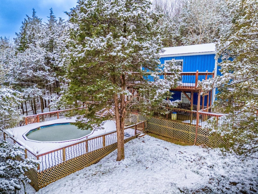
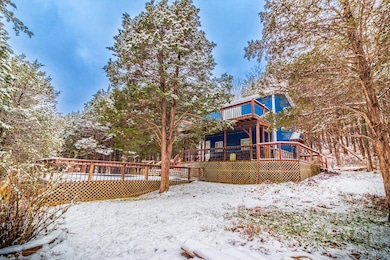
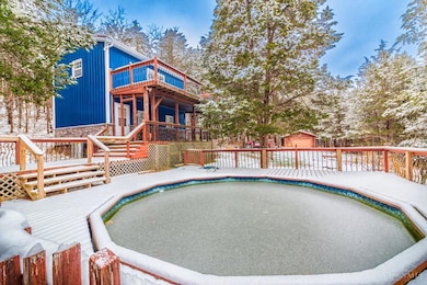
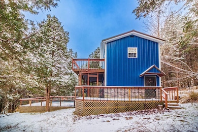
- Above Ground Pool
- Deck
- No HOA
About This Home
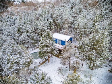
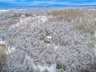
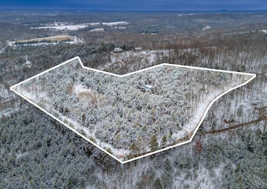
Sold As-Is - Scenic Setting with Tons of Potential Discover an excellent opportunity at the end of a quiet driveway overlooking beautiful country views. Situated on just over 6 acres of nature-rich habitat, making it a true wildlife paradise for anyone who enjoys peaceful surroundings, birdwatching, or watching deer graze at dusk. This property features a home that has been mostly demoed inside and is ready for your vision and restoration. With its elevated setting, large deck, and pool area, this could become a standout retreat with the right updates. A detached garage provides great storage or workshop space, and a newer shed adds even more utility. County water tap is installed, just not yet connected to the home. If you're looking for a project with fantastic surroundings and solid amenities already in place, this property is a must-see. Bring your tools and imagination, your future home or investment starts here.
Home Details
Home Type
- Single Family
Est. Annual Taxes
- $972
Year Built
- Built in 1998
Lot Details
- 6.8 Acre Lot
- Sloped Lot
- Oak Trees
- Heavily Wooded Lot
- Cedar Trees
- Property is zoned Unzoned
Parking
- 1 Car Detached Garage
- Gravel Driveway
Home Design
- Metal Roof
Interior Spaces
- 768 Sq Ft Home
- 2-Story Property
- Vinyl Clad Windows
- Views of Woods
- Crawl Space
Bedrooms and Bathrooms
- 3 Bedrooms
- Main Floor Bedroom
- 1 Full Bathroom
- Bathtub with Shower
Outdoor Features
- Above Ground Pool
- Deck
- Shed
Utilities
- Natural Gas Not Available
- Electric Water Heater
- Aerobic Septic System
- Septic Tank
Community Details
- No Home Owners Association
Map
Home Values in the Area
Average Home Value in this Area
Tax History
| Year | Tax Paid | Tax Assessment Tax Assessment Total Assessment is a certain percentage of the fair market value that is determined by local assessors to be the total taxable value of land and additions on the property. | Land | Improvement |
|---|---|---|---|---|
| 2024 | $203 | $3,850 | $3,850 | $0 |
| 2023 | $174 | $3,850 | $3,850 | $0 |
| 2022 | $131 | $2,800 | $2,800 | $0 |
| 2021 | $108 | $2,800 | $2,800 | $0 |
| 2020 | $105 | $2,800 | $2,800 | $0 |
| 2019 | $105 | $2,800 | $2,800 | $0 |
| 2018 | $103 | $2,800 | $2,800 | $0 |
| 2017 | $102 | $2,800 | $2,800 | $0 |
| 2016 | $1,892 | $2,800 | $2,800 | $0 |
| 2015 | $744 | $21,250 | $4,170 | $17,080 |
| 2014 | $744 | $21,250 | $4,170 | $17,080 |
Property History
| Date | Event | Price | List to Sale | Price per Sq Ft |
|---|---|---|---|---|
| 12/04/2025 12/04/25 | For Sale | $120,000 | -- | $156 / Sq Ft |
Purchase History
| Date | Type | Sale Price | Title Company |
|---|---|---|---|
| Quit Claim Deed | $23,500 | Bay National Title | |
| Sheriffs Deed | $60,000 | None Available | |
| Warranty Deed | $83,450 | None Available | |
| Deed | $83,000 | -- | |
| Deed | $26,000 | -- |
Mortgage History
| Date | Status | Loan Amount | Loan Type |
|---|---|---|---|
| Previous Owner | $111,250 | Assumption |
Source: MLS of Greater Cincinnati (CincyMLS)
MLS Number: 1863516
APN: 091-00-00-069.000
Disclaimer: Certain information contained herein is derived from information provided by parties other than Homes.com. All information provided is deemed reliable, but is not guaranteed to be accurate and should be independently verified.
![]() The data relating to real estate for sale on this website comes in part from the Broker Reciprocity programs of the MLS of Greater Cincinnati, Inc.. Those listings held by brokerage firms other than Ten-X are marked with the Broker Reciprocity logo and house icon. The properties displayed may not be all of the properties available through Broker Reciprocity.
The data relating to real estate for sale on this website comes in part from the Broker Reciprocity programs of the MLS of Greater Cincinnati, Inc.. Those listings held by brokerage firms other than Ten-X are marked with the Broker Reciprocity logo and house icon. The properties displayed may not be all of the properties available through Broker Reciprocity.
IDX information is provided exclusively for personal, non-commercial use, and may not be used for any purpose other than to identify prospective properties consumers may be interested in purchasing.
Information is deemed reliable but not guaranteed.
Ten-X does not display the entire Cincinnati MLS Broker Reciprocity™ database on this web site. The listings of some real estate brokerage firms have been excluded.
Copyright 2025, MLS of Greater Cincinnati, Inc. All rights reserved
- 210 Walt Alsgood Rd
- 292 Larry Baynum Rd
- 3460 Logans Ln
- 19004 State Route 41
- 13465 State Route 41
- 0 Paradise Valley Rd Unit 1852764
- 108 Chirsdon Ln
- 0 State Route 41 Unit 1830107
- 3551 Unity Rd
- 831 Tom Brown Rd
- 4016 Unity Rd
- 668 Fawcett Rd
- 125 Robinette Rd
- 4603 Wheat Ridge Rd
- 260 Randy St
- 917 Logans Ln
- 216 Kurt St
- 1478 Robinson Hollow Rd
- 120 Randy St
- 410 Owens Rd
- 1021 Unity Rd
- 671 Shaker Run Rd
- 507 W 6th St
- 1890 Vista Cir
- 1960 Justin Way
- 512 Florence St
- 208 Sutton St Unit 3
- 610 Markley Ave
- 401 Marshall Ave
- 679 S Main St
- 104 S Pleasant St Unit 2
- 12120 Valerie Dr
- 135 Candlelight Way
- 338 S High St Unit 4
- 319 Pleasant St
- 226 Woodland Dr
- 3899 Augusta Minerva Rd
- 112 Ivy Trace Unit A
