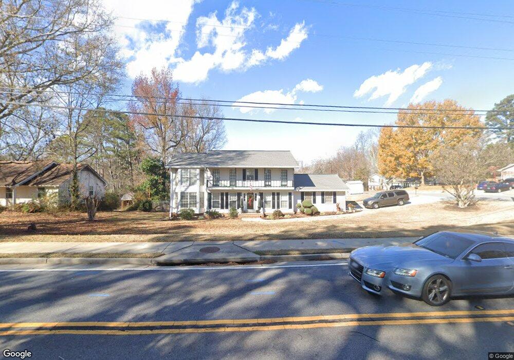
3636 S Bogan Rd Buford, GA 30519
Estimated Value: $339,000 - $576,000
4
Beds
3
Baths
3,074
Sq Ft
$149/Sq Ft
Est. Value
About This Home
This home is located at 3636 S Bogan Rd, Buford, GA 30519 and is currently estimated at $458,653, approximately $149 per square foot. 3636 S Bogan Rd is a home located in Gwinnett County with nearby schools including Buford Elementary School, Buford Senior Academy, and Buford Academy.
Ownership History
Date
Name
Owned For
Owner Type
Purchase Details
Closed on
Aug 26, 2019
Sold by
Rungruang Nopporn
Bought by
Rungruang Nopporn and Rungruang Beverly
Current Estimated Value
Home Financials for this Owner
Home Financials are based on the most recent Mortgage that was taken out on this home.
Original Mortgage
$208,434
Outstanding Balance
$181,700
Interest Rate
3.37%
Mortgage Type
FHA
Estimated Equity
$276,953
Create a Home Valuation Report for This Property
The Home Valuation Report is an in-depth analysis detailing your home's value as well as a comparison with similar homes in the area
Home Values in the Area
Average Home Value in this Area
Purchase History
| Date | Buyer | Sale Price | Title Company |
|---|---|---|---|
| Rungruang Nopporn | -- | -- |
Source: Public Records
Mortgage History
| Date | Status | Borrower | Loan Amount |
|---|---|---|---|
| Open | Rungruang Nopporn | $208,434 |
Source: Public Records
Tax History Compared to Growth
Tax History
| Year | Tax Paid | Tax Assessment Tax Assessment Total Assessment is a certain percentage of the fair market value that is determined by local assessors to be the total taxable value of land and additions on the property. | Land | Improvement |
|---|---|---|---|---|
| 2024 | $623 | $155,720 | $24,000 | $131,720 |
| 2023 | $623 | $174,800 | $24,000 | $150,800 |
| 2022 | $623 | $165,120 | $18,000 | $147,120 |
| 2021 | $623 | $107,520 | $12,000 | $95,520 |
| 2020 | $623 | $107,520 | $12,000 | $95,520 |
| 2019 | $563 | $83,600 | $10,000 | $73,600 |
| 2018 | $563 | $83,600 | $10,000 | $73,600 |
| 2016 | $559 | $54,120 | $8,400 | $45,720 |
| 2015 | $579 | $54,120 | $8,400 | $45,720 |
| 2014 | $589 | $54,120 | $8,400 | $45,720 |
Source: Public Records
Map
Nearby Homes
- 2040 Harvest Ridge Cir
- 2040 Harvest Ridge Cir NE
- 3684 Heritage Crest Pkwy
- 2140 Harvest Ridge Cir
- 3476 Harvest Ridge Ln
- 2183 Ivy Crest Dr
- 1970 Sturbridge Ln Unit 1
- 3560 Hanover Dr
- 3600 Devenwood Way
- 3573 Fallen Oak Dr
- 3534 Fallen Oak Ln
- 3410 Coles Creek Dr
- 2361 Black Bear Ct Unit 2
- 1781 Plunketts Rd
- 2182 Misty Brook Ct
- 2148 Splitrail Trail
- The Aspen A Plan at Fern Hollow
- The Hickory F Plan at Fern Hollow
- The Danbury J Plan at Fern Hollow
- 2272 Misty Brook Ct
- 3632 S Bogan Rd
- 2090 Rock Creek Rd
- S S Bogan Rd Unit 2
- S S Bogan Rd
- 3642 S Bogan Rd
- 2089 Rock Creek Rd
- 2080 Harvest Ridge Cir
- 2082 Rock Creek Rd Unit 14
- 2082 Rock Creek Rd
- 2070 Harvest Ridge Cir
- 2070 Harvest Ridge Cir Unit 2/9
- 3623 Aspen Ct
- 2060 Harvest Ridge Cir
- 2070 Harvest Ridge Cir NE
- 3633 Aspen Ct
- 2100 Harvest Ridge Cir
- 3646 S Bogan Rd
- 2081 Rock Creek Rd
- 2030 Harvest Ridge Cir
- 2074 Rock Creek Rd Unit 1