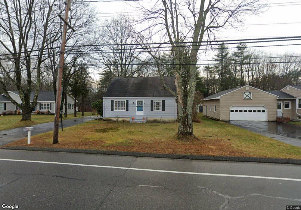
365 E Bridge St Westbrook, ME 04092
Estimated Value: $416,313 - $493,000
3
Beds
1
Bath
1,452
Sq Ft
$311/Sq Ft
Est. Value
About This Home
This home is located at 365 E Bridge St, Westbrook, ME 04092 and is currently estimated at $452,078, approximately $311 per square foot. 365 E Bridge St is a home located in Cumberland County with nearby schools including Westbrook High School, St. Brigid School, and Breakwater School.
Ownership History
Date
Name
Owned For
Owner Type
Purchase Details
Closed on
Oct 27, 2021
Sold by
Huot Ravy and Ung Pisey
Bought by
Ung Pisey
Current Estimated Value
Home Financials for this Owner
Home Financials are based on the most recent Mortgage that was taken out on this home.
Original Mortgage
$143,000
Interest Rate
3.76%
Mortgage Type
Purchase Money Mortgage
Purchase Details
Closed on
Apr 20, 2010
Sold by
Lasalle Aiden E
Bought by
Huot Ravy and Huot Pisey
Home Financials for this Owner
Home Financials are based on the most recent Mortgage that was taken out on this home.
Original Mortgage
$186,734
Interest Rate
4.97%
Mortgage Type
FHA
Create a Home Valuation Report for This Property
The Home Valuation Report is an in-depth analysis detailing your home's value as well as a comparison with similar homes in the area
Home Values in the Area
Average Home Value in this Area
Purchase History
| Date | Buyer | Sale Price | Title Company |
|---|---|---|---|
| Ung Pisey | -- | None Available | |
| Huot Ravy | -- | -- |
Source: Public Records
Mortgage History
| Date | Status | Borrower | Loan Amount |
|---|---|---|---|
| Previous Owner | Ung Pisey | $143,000 | |
| Previous Owner | Huot Ravy | $186,734 |
Source: Public Records
Tax History
| Year | Tax Paid | Tax Assessment Tax Assessment Total Assessment is a certain percentage of the fair market value that is determined by local assessors to be the total taxable value of land and additions on the property. | Land | Improvement |
|---|---|---|---|---|
| 2023 | $4,223 | $253,200 | $84,400 | $168,800 |
| 2022 | $3,817 | $210,900 | $70,300 | $140,600 |
| 2021 | $3,760 | $210,900 | $70,300 | $140,600 |
| 2020 | $3,767 | $210,900 | $70,300 | $140,600 |
| 2019 | $3,767 | $210,900 | $70,300 | $140,600 |
| 2018 | $3,559 | $178,400 | $61,200 | $117,200 |
| 2017 | $3,368 | $178,400 | $61,200 | $117,200 |
| 2016 | $3,283 | $178,400 | $61,200 | $117,200 |
| 2015 | $3,204 | $178,400 | $61,200 | $117,200 |
| 2014 | $3,068 | $178,400 | $61,200 | $117,200 |
| 2013 | $3,068 | $178,400 | $61,200 | $117,200 |
Source: Public Records
Map
Nearby Homes
- 7 Kasseys Way Unit 5
- 22 Collins Place Dr Unit 4
- 84 Hillside Rd
- 7 Collins Place Unit 6
- 7 Apex Dr Unit 2
- 5 Apex Dr Unit 1
- 0 Reed St
- 3 Collins Place Unit 5
- Lot 15&16 Chickadee Ln
- 290 Bridgton Rd Unit 1
- 272 Cumberland St
- 858 Riverside St
- 22 Berkeley St
- 315 Bridge St
- 60 Euclid Ave
- 48 Nasson Ave
- Lot TBD Epping St
- 106 Euclid Ave
- 151 Brooks Edge Farm Rd Unit 68
- 95 Lane Ave
- 357 E Bridge St
- 371 E Bridge St
- 351 E Bridge St
- 375 E Bridge St
- 0 E Bridge St
- 345 E Bridge St
- 343 E Bridge St
- 13 Kasseys Way Unit 13
- 341 E Bridge St
- 105 Puritan Dr
- 13-15 Kasseys Way
- 350 E Bridge St
- 7-9 Kasseys Way
- 15 Kasseys Way Unit 2
- 111 Puritan Dr
- 117 Puritan Dr
- 337 E Bridge St
- 187 Puritan Dr
- 123 Puritan Dr
- 181 Puritan Dr
Your Personal Tour Guide
Ask me questions while you tour the home.