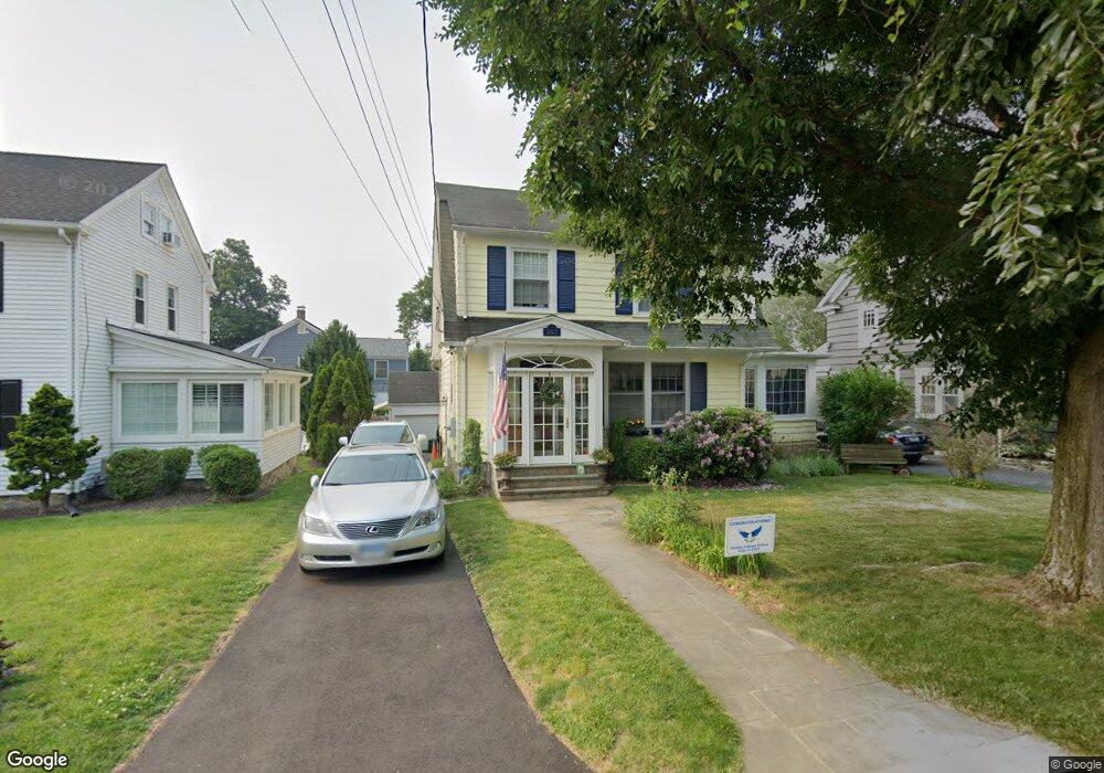
367 Meadowbrook Rd Fairfield, CT 06824
University NeighborhoodEstimated Value: $942,000 - $1,155,000
4
Beds
3
Baths
2,167
Sq Ft
$474/Sq Ft
Est. Value
About This Home
This home is located at 367 Meadowbrook Rd, Fairfield, CT 06824 and is currently estimated at $1,026,988, approximately $473 per square foot. 367 Meadowbrook Rd is a home located in Fairfield County with nearby schools including Osborn Hill Elementary School, Fairfield Woods Middle School, and Fairfield Ludlowe High School.
Ownership History
Date
Name
Owned For
Owner Type
Purchase Details
Closed on
Jan 24, 1992
Sold by
Williams Robert L and Williams Kathryn S
Bought by
Cullinan Patricik J and Cullinan Leslie B
Current Estimated Value
Purchase Details
Closed on
Jun 11, 1990
Sold by
Collins Lillian M
Bought by
Williams Robert L
Create a Home Valuation Report for This Property
The Home Valuation Report is an in-depth analysis detailing your home's value as well as a comparison with similar homes in the area
Home Values in the Area
Average Home Value in this Area
Purchase History
| Date | Buyer | Sale Price | Title Company |
|---|---|---|---|
| Cullinan Patricik J | $215,000 | -- | |
| Cullinan Patricik J | $215,000 | -- | |
| Williams Robert L | $190,000 | -- |
Source: Public Records
Mortgage History
| Date | Status | Borrower | Loan Amount |
|---|---|---|---|
| Open | Williams Robert L | $402,000 | |
| Closed | Williams Robert L | $75,000 | |
| Closed | Williams Robert L | $40,000 |
Source: Public Records
Tax History
| Year | Tax Paid | Tax Assessment Tax Assessment Total Assessment is a certain percentage of the fair market value that is determined by local assessors to be the total taxable value of land and additions on the property. | Land | Improvement |
|---|---|---|---|---|
| 2025 | $10,358 | $364,840 | $219,170 | $145,670 |
| 2024 | $10,179 | $364,840 | $219,170 | $145,670 |
| 2023 | $10,037 | $364,840 | $219,170 | $145,670 |
| 2022 | $9,938 | $364,840 | $219,170 | $145,670 |
| 2021 | $6,341 | $364,840 | $219,170 | $145,670 |
| 2020 | $10,813 | $403,620 | $237,790 | $165,830 |
| 2019 | $6,453 | $403,620 | $237,790 | $165,830 |
| 2018 | $10,639 | $403,620 | $237,790 | $165,830 |
| 2017 | $6,393 | $403,620 | $237,790 | $165,830 |
| 2016 | $10,272 | $403,620 | $237,790 | $165,830 |
| 2015 | $10,309 | $415,870 | $264,250 | $151,620 |
| 2014 | $10,147 | $415,870 | $264,250 | $151,620 |
Source: Public Records
Map
Nearby Homes
- 164 Wakeman Rd
- 15 Barton Rd
- 77 Meadowbrook Rd
- 20 Ermine St
- 70 Meadow Ridge Rd
- 1478 Jennings Rd
- 98 Cambridge St
- 341 Crestwood Rd
- 855 Riverside Dr
- 1091 Round Hill Rd
- 3250 Fairfield Ave Unit 302
- 274 High St
- 68 Figlar Ave
- 598 S Benson Rd
- 315 Seaside Ave
- 90 Clarkson St
- 245 Unquowa Rd Unit 82
- 245 Unquowa Rd Unit 6
- 165 Bennett St
- 1353 Mill Plain Rd
- 357 Meadowbrook Rd
- 377 Meadowbrook Rd
- 179 Fairview Ave
- 393 Meadowbrook Rd
- 159 Fairview Ave
- 105 Barlow Plain Dr
- 366 Meadowbrook Rd
- 337 Meadowbrook Rd
- 396 Meadowbrook Rd
- 176 Fairview Ave
- 221 Fairview Ave
- 378 Meadowbrook Rd
- 166 Fairview Ave
- 165 Fairview Ave
- 103 Barlow Plain Dr
- 147 Fairview Ave
- 237 Fairview Ave
- 317 Meadowbrook Rd
- 330 Meadowbrook Rd
- 421 Meadowbrook Rd
Your Personal Tour Guide
Ask me questions while you tour the home.