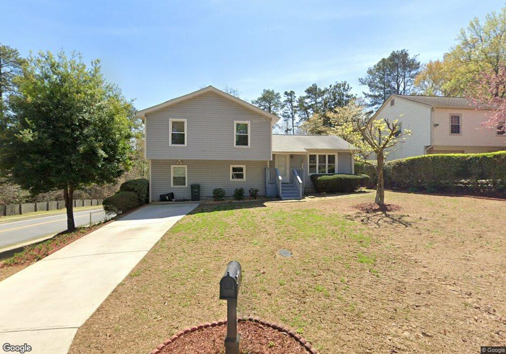
368 Cedar Trace SW Marietta, GA 30008
Southwestern Marietta NeighborhoodEstimated Value: $279,000 - $326,000
3
Beds
2
Baths
1,208
Sq Ft
$253/Sq Ft
Est. Value
About This Home
This home is located at 368 Cedar Trace SW, Marietta, GA 30008 and is currently estimated at $305,741, approximately $253 per square foot. 368 Cedar Trace SW is a home located in Cobb County with nearby schools including Dunleith Elementary School, Marietta Sixth Grade Academy, and Marietta Middle School.
Ownership History
Date
Name
Owned For
Owner Type
Purchase Details
Closed on
Oct 21, 2015
Sold by
Mccoy Cora E
Bought by
Mccoy Janice G
Current Estimated Value
Purchase Details
Closed on
Jul 11, 1995
Sold by
Fleet Finance Inc Ga
Bought by
Mccoy Cora E
Purchase Details
Closed on
Oct 15, 1994
Sold by
Montgomery Lola D
Bought by
Fleet Finance Inc Ga
Create a Home Valuation Report for This Property
The Home Valuation Report is an in-depth analysis detailing your home's value as well as a comparison with similar homes in the area
Home Values in the Area
Average Home Value in this Area
Purchase History
| Date | Buyer | Sale Price | Title Company |
|---|---|---|---|
| Mccoy Janice G | -- | -- | |
| Mccoy Cora E | $63,200 | -- | |
| Fleet Finance Inc Ga | $70,600 | -- |
Source: Public Records
Mortgage History
| Date | Status | Borrower | Loan Amount |
|---|---|---|---|
| Closed | Mccoy Cora E | $0 |
Source: Public Records
Tax History Compared to Growth
Tax History
| Year | Tax Paid | Tax Assessment Tax Assessment Total Assessment is a certain percentage of the fair market value that is determined by local assessors to be the total taxable value of land and additions on the property. | Land | Improvement |
|---|---|---|---|---|
| 2025 | $177 | $73,220 | $23,400 | $49,820 |
| 2024 | $177 | $73,220 | $23,400 | $49,820 |
| 2023 | $25 | $73,220 | $23,400 | $49,820 |
| 2022 | $177 | $62,492 | $23,400 | $39,092 |
| 2021 | $185 | $62,492 | $23,400 | $39,092 |
| 2020 | $184 | $49,956 | $10,800 | $39,156 |
| 2019 | $184 | $49,956 | $10,800 | $39,156 |
| 2018 | $184 | $49,956 | $10,800 | $39,156 |
| 2017 | $147 | $44,424 | $10,800 | $33,624 |
| 2016 | $147 | $32,344 | $5,400 | $26,944 |
| 2015 | $161 | $32,344 | $5,400 | $26,944 |
| 2014 | $167 | $32,344 | $0 | $0 |
Source: Public Records
Map
Nearby Homes
- 393 Cedar Trace SW Unit 1
- 264 Juliet Ln SW
- 1048 Brownstone Dr Unit 3
- 243 Brownstone Cir Unit 25
- 1166 Booth Rd SW Unit 407
- 1166 Booth Rd SW Unit 205
- 1166 Booth Rd SW Unit 906
- 1166 Booth Rd SW Unit 908
- 1166 Booth Rd SW Unit 610
- 994 Powder Springs St
- 1038 Arden Dr SW
- 1230 Arden Dr SW
- 105 Grampian Ct Unit 13
- 1239 Grampian Pass Unit 11
- 1252 Grampian Pass Unit 9
- 852 Hickory Dr SW
- 150 Creighton Ln
- 644 Laurel Wood Dr SW
- 372 Cedar Trace SW
- 1044 Booth Rd SW
- 369 Cedar Trace SW Unit 1
- 378 Cedar Trace SW
- 373 Cedar Trace SW
- 983 Brownstone Ln Unit 65
- 979 Brownstone Ln Unit 17
- 979 Brownstone Ln
- 981 Brownstone Ln Unit 17
- 983 Brownstone Ln Unit 16
- 979 Brownstone Ln Unit 67
- 977 Brownstone Ln Unit 17
- 977 Brownstone Ln
- 977 Brownstone Ln Unit 977
- 377 Cedar Trace SW Unit 1
- 985 Brownstone Ln
- 975 Brownstone Ln Unit 17
- 382 Cedar Trace SW
- 486 Burns Ct SW
- 987 Brownstone Ln Unit 63