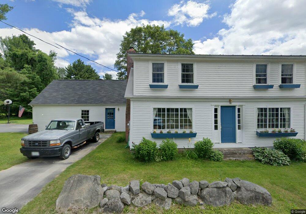
37 Haynes Rd Newbury, NH 03255
Estimated Value: $390,000 - $699,000
3
Beds
2
Baths
3,271
Sq Ft
$177/Sq Ft
Est. Value
About This Home
This home is located at 37 Haynes Rd, Newbury, NH 03255 and is currently estimated at $578,368, approximately $176 per square foot. 37 Haynes Rd is a home located in Merrimack County with nearby schools including Kearsarge Regional Elementary School at Bradford, Kearsarge Regional Middle School, and Kearsarge Regional High School.
Ownership History
Date
Name
Owned For
Owner Type
Purchase Details
Closed on
Jul 31, 2006
Sold by
Smerald Peter D and Smerald Lauri Ann
Bought by
Richer Lori D
Current Estimated Value
Home Financials for this Owner
Home Financials are based on the most recent Mortgage that was taken out on this home.
Original Mortgage
$276,000
Outstanding Balance
$79,411
Interest Rate
6.67%
Estimated Equity
$498,957
Create a Home Valuation Report for This Property
The Home Valuation Report is an in-depth analysis detailing your home's value as well as a comparison with similar homes in the area
Home Values in the Area
Average Home Value in this Area
Purchase History
| Date | Buyer | Sale Price | Title Company |
|---|---|---|---|
| Richer Lori D | $345,000 | -- | |
| Richer Nathan G | -- | -- |
Source: Public Records
Mortgage History
| Date | Status | Borrower | Loan Amount |
|---|---|---|---|
| Open | Richer Nathan G | $276,000 | |
| Closed | Richer Lori D | $276,000 |
Source: Public Records
Tax History Compared to Growth
Tax History
| Year | Tax Paid | Tax Assessment Tax Assessment Total Assessment is a certain percentage of the fair market value that is determined by local assessors to be the total taxable value of land and additions on the property. | Land | Improvement |
|---|---|---|---|---|
| 2024 | $4,466 | $342,230 | $79,430 | $262,800 |
| 2023 | $4,466 | $342,230 | $79,430 | $262,800 |
| 2022 | $3,720 | $326,855 | $79,855 | $247,000 |
| 2021 | $3,718 | $326,751 | $79,751 | $247,000 |
| 2020 | $3,578 | $216,576 | $64,876 | $151,700 |
| 2019 | $3,440 | $216,656 | $64,956 | $151,700 |
| 2018 | $3,360 | $216,748 | $65,048 | $151,700 |
| 2017 | $3,397 | $216,257 | $65,057 | $151,200 |
| 2016 | $3,468 | $216,102 | $64,902 | $151,200 |
| 2015 | $3,571 | $219,335 | $64,835 | $154,500 |
| 2014 | $3,397 | $219,335 | $64,835 | $154,500 |
| 2013 | $3,277 | $219,471 | $64,971 | $154,500 |
Source: Public Records
Map
Nearby Homes
- 91 Chalk Pond Rd
- 344 Chalk Pond Rd
- Lower Crest Rd
- 25 Hilltop Dr
- 81 Gerald Dr
- 0 Summit Rd Unit 431
- 00 Mountainside Dr
- 329 Forest Acres Rd
- 273 Forest Acres Rd
- 0 Hominy Pot Rd Unit 5036928
- 106-23 Fieldstone Ln
- 213 Bay Point Rd
- 240 Bay Point Rd
- 106 Fieldstone Ln
- 1029 Route 103a
- 12 Shadow Ln
- 0 Crest Dr Unit 4996159
- 0 Route 103a Map 91 Lot 37 38 Unit 37 & 38 5058839
- 0 Lakewood Manor Rd Unit 467
- 81 Lakewood Manor Rd
- 56 Haynes Rd
- 38 Haynes Rd
- 52 Haynes Rd
- 262 Baker Hill Rd
- 284 Stone House Rd
- 15 Stoney Brook Rd
- 0 Stoney Brook Rd
- 0 Stoney Brook Rd Unit 4478132
- 17 Stoney Brook Rd
- 33 Stoney Brook Rd
- 251 Baker Hill Rd
- 381 Baker Hill Rd
- 236 Baker Hill Rd
- 515 Baker Hill Rd
- 515 Baker Hill Rd Unit 4
- 51 Stoney Brook Rd
- 39 Stoney Brook Rd
- 514 Baker Hill Rd
- 514 Baker Hill Rd
- 68 Stoney Brook Rd