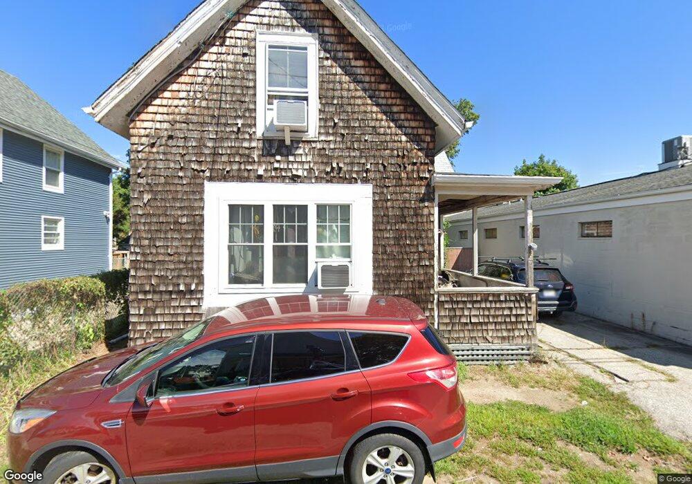
37 Maple Ave Riverside, RI 02915
Riverside NeighborhoodEstimated Value: $348,000 - $417,000
3
Beds
2
Baths
1,275
Sq Ft
$295/Sq Ft
Est. Value
About This Home
This home is located at 37 Maple Ave, Riverside, RI 02915 and is currently estimated at $376,038, approximately $294 per square foot. 37 Maple Ave is a home located in Providence County with nearby schools including East Providence High School, St Mary Academy-Bay View, and The Gordon School.
Ownership History
Date
Name
Owned For
Owner Type
Purchase Details
Closed on
Apr 29, 2005
Sold by
Repoza Michael T
Bought by
Zeigler Matthew J and Zeigler Jessica A
Current Estimated Value
Home Financials for this Owner
Home Financials are based on the most recent Mortgage that was taken out on this home.
Original Mortgage
$188,977
Outstanding Balance
$98,594
Interest Rate
5.95%
Mortgage Type
VA
Estimated Equity
$277,444
Purchase Details
Closed on
Jan 23, 2004
Sold by
Mello Ernestine Ann and Cinq-Mars Josephine
Bought by
Repoza Michael
Home Financials for this Owner
Home Financials are based on the most recent Mortgage that was taken out on this home.
Original Mortgage
$112,000
Interest Rate
5.89%
Mortgage Type
Purchase Money Mortgage
Create a Home Valuation Report for This Property
The Home Valuation Report is an in-depth analysis detailing your home's value as well as a comparison with similar homes in the area
Home Values in the Area
Average Home Value in this Area
Purchase History
| Date | Buyer | Sale Price | Title Company |
|---|---|---|---|
| Zeigler Matthew J | $185,000 | -- | |
| Repoza Michael | $140,000 | -- | |
| Zeigler Matthew J | $185,000 | -- | |
| Repoza Michael | $140,000 | -- |
Source: Public Records
Mortgage History
| Date | Status | Borrower | Loan Amount |
|---|---|---|---|
| Open | Repoza Michael | $40,000 | |
| Open | Repoza Michael | $188,977 | |
| Closed | Repoza Michael | $188,977 | |
| Previous Owner | Repoza Michael | $112,000 |
Source: Public Records
Tax History Compared to Growth
Tax History
| Year | Tax Paid | Tax Assessment Tax Assessment Total Assessment is a certain percentage of the fair market value that is determined by local assessors to be the total taxable value of land and additions on the property. | Land | Improvement |
|---|---|---|---|---|
| 2025 | $4,172 | $319,200 | $80,400 | $238,800 |
| 2024 | $3,446 | $224,800 | $67,000 | $157,800 |
| 2023 | $3,318 | $224,800 | $67,000 | $157,800 |
| 2022 | $3,093 | $141,500 | $47,100 | $94,400 |
| 2021 | $3,042 | $141,500 | $47,100 | $94,400 |
| 2020 | $2,913 | $141,500 | $47,100 | $94,400 |
| 2019 | $2,833 | $141,500 | $47,100 | $94,400 |
| 2018 | $2,775 | $121,300 | $47,200 | $74,100 |
| 2017 | $2,713 | $121,300 | $47,200 | $74,100 |
| 2016 | $2,700 | $121,300 | $47,200 | $74,100 |
| 2015 | $3,013 | $131,300 | $48,100 | $83,200 |
| 2014 | $3,013 | $131,300 | $48,100 | $83,200 |
Source: Public Records
Map
Nearby Homes
- 33 Pine St Unit 35
- 1 Holly St
- 27 Holly St
- 72 Stowe Ave
- 35 E Knowlton St
- 129 Shore Rd
- 25 Arnold St
- 151 Willett Ave Unit 2
- 151 Willett Ave Unit 5
- 25 Elinora St
- 43 Bullocks Point Ave Unit 4A
- 25 Bullocks Point Ave Unit 5C
- 41 White Ave
- 6 Fuller Ave
- 6 Meadowcrest Dr
- 32 Woodbine St
- 25 Winslow St
- 36 Woodbine St
- 3421 Pawtucket Ave
- 26 Glen St