
Seller's Agent in 2025
Judi Caracausa
William Pitt
(860) 912-9903
61 in this area
175 Total Sales
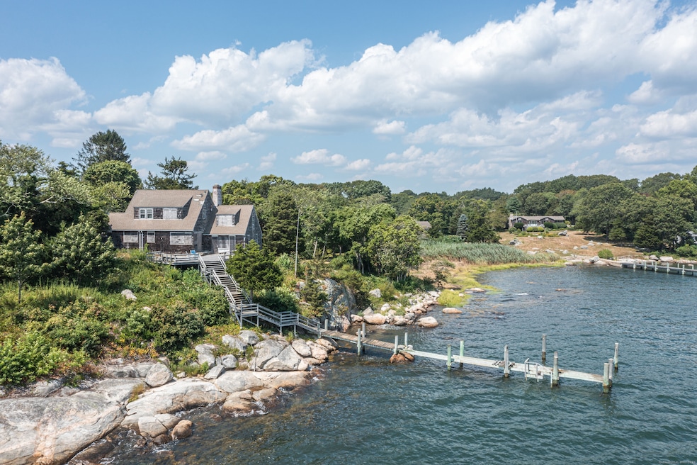
Magnificent Direct Waterfront with Unobstructed Water views and Private Deep Water Dock. All nestled on 1.24 Acres with 201' of Direct Water Front. Rare and Unique setting with views to Fishers Island Sound, Enders Island, Stonington and beyond. The drive from the road entrance rises and winds gracefully past tall pine trees and mature plantings to the 28' elevation where the existing home structure is located. This exceptional parcel offers a once-in-a-lifetime canvas for your custom-designed coastal retreat. Enjoy your private fixed dock with appx. 4 1/2 ' of water at low tide, and appx. 6' at high tide. Mean Low Tide in the immediate adjacent water is 7'. This property is located in a very private sector of Mason's Island, southwest of the fresh water pond. This existing house should be removed and rebuilt to your specifications. There is also a 2 bay garage structure at the entrance to this property. This incomparable property has been owned by only two families in the past 103 years. Awaken each morning to sweeping water views, spend your days sailing, boating, kayaking or simply basking in the serenity of this private island sanctuary, and hear the breaking waves. With year-round access to the beauty and recreation of the water, this is more than a homesite - it's a dream come true.
Last Agent to Sell the Property
William Pitt Sotheby's Int'l Brokerage Phone: (860) 912-9903 License #REB.0788601 Listed on: 08/29/2025
Last Buyer's Agent
William Pitt Sotheby's Int'l Brokerage Phone: (860) 912-9903 License #REB.0788601 Listed on: 08/29/2025
| Date | Type | Sale Price | Title Company |
|---|---|---|---|
| Quit Claim Deed | -- | None Available | |
| Quit Claim Deed | -- | None Available | |
| Deed | -- | -- |
| Date | Status | Loan Amount | Loan Type |
|---|---|---|---|
| Closed | $800,000 | Stand Alone Refi Refinance Of Original Loan | |
| Previous Owner | $550,000 | No Value Available | |
| Previous Owner | $500,000 | No Value Available |
| Date | Event | Price | List to Sale | Price per Sq Ft |
|---|---|---|---|---|
| 11/13/2025 11/13/25 | Sold | $2,820,000 | +2.5% | $1,442 / Sq Ft |
| 09/26/2025 09/26/25 | Pending | -- | -- | -- |
| 08/29/2025 08/29/25 | For Sale | $2,750,000 | -- | $1,407 / Sq Ft |
| Year | Tax Paid | Tax Assessment Tax Assessment Total Assessment is a certain percentage of the fair market value that is determined by local assessors to be the total taxable value of land and additions on the property. | Land | Improvement |
|---|---|---|---|---|
| 2025 | $22,637 | $1,049,000 | $981,400 | $67,600 |
| 2024 | $21,872 | $1,049,000 | $981,400 | $67,600 |
| 2023 | $19,983 | $1,049,000 | $981,400 | $67,600 |
| 2022 | $19,813 | $760,300 | $709,800 | $50,500 |
| 2021 | $19,703 | $760,300 | $709,800 | $50,500 |
| 2020 | $19,129 | $760,300 | $709,800 | $50,500 |
| 2019 | $19,053 | $760,300 | $709,800 | $50,500 |
| 2018 | $18,483 | $760,300 | $709,800 | $50,500 |
| 2017 | $20,682 | $840,400 | $791,700 | $48,700 |
| 2016 | $20,119 | $840,400 | $791,700 | $48,700 |
| 2015 | $19,287 | $840,400 | $791,700 | $48,700 |
| 2014 | $18,539 | $840,400 | $791,700 | $48,700 |
Seller's Agent in 2025
Judi Caracausa
William Pitt
(860) 912-9903
61 in this area
175 Total Sales
Source: SmartMLS
MLS Number: 24118944
APN: STON-000179-000004-000007
Disclaimer: Certain information contained herein is derived from information provided by parties other than Homes.com. All information provided is deemed reliable, but is not guaranteed to be accurate and should be independently verified.
![]() IDX information is provided exclusively for personal, non-commercial use, and may not be used for any purpose other than to identify prospective properties consumers may be interested in purchasing. Information is deemed reliable but not guaranteed.
IDX information is provided exclusively for personal, non-commercial use, and may not be used for any purpose other than to identify prospective properties consumers may be interested in purchasing. Information is deemed reliable but not guaranteed.