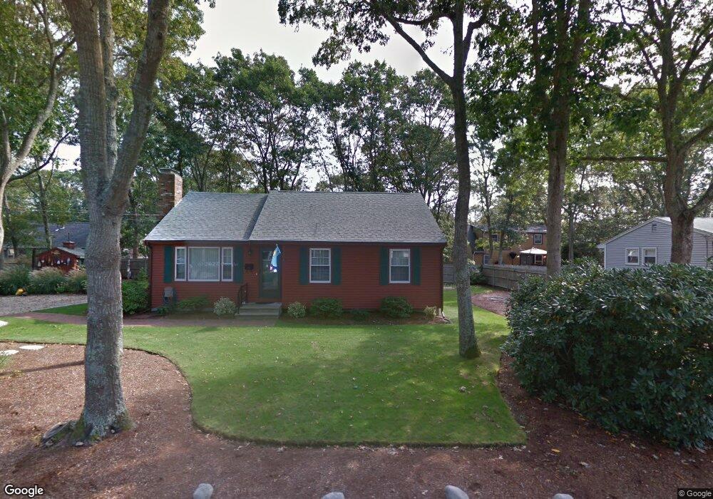
37 Oak St Teaticket, MA 02536
Teaticket NeighborhoodEstimated Value: $692,000 - $768,000
3
Beds
2
Baths
800
Sq Ft
$904/Sq Ft
Est. Value
About This Home
This home is located at 37 Oak St, Teaticket, MA 02536 and is currently estimated at $723,096, approximately $903 per square foot. 37 Oak St is a home located in Barnstable County with nearby schools including Teaticket Elementary School, Morse Pond School, and Lawrence School.
Ownership History
Date
Name
Owned For
Owner Type
Purchase Details
Closed on
May 8, 1997
Sold by
Speranza Bernadette and Speranza Leo S
Bought by
Hart Joseph R
Current Estimated Value
Home Financials for this Owner
Home Financials are based on the most recent Mortgage that was taken out on this home.
Original Mortgage
$101,600
Outstanding Balance
$12,474
Interest Rate
7.88%
Mortgage Type
Purchase Money Mortgage
Estimated Equity
$710,622
Create a Home Valuation Report for This Property
The Home Valuation Report is an in-depth analysis detailing your home's value as well as a comparison with similar homes in the area
Home Values in the Area
Average Home Value in this Area
Purchase History
| Date | Buyer | Sale Price | Title Company |
|---|---|---|---|
| Hart Joseph R | $127,000 | -- | |
| Hart Joseph R | $127,000 | -- |
Source: Public Records
Mortgage History
| Date | Status | Borrower | Loan Amount |
|---|---|---|---|
| Open | Hart Joseph R | $101,600 | |
| Closed | Hart Joseph R | $101,600 |
Source: Public Records
Tax History Compared to Growth
Tax History
| Year | Tax Paid | Tax Assessment Tax Assessment Total Assessment is a certain percentage of the fair market value that is determined by local assessors to be the total taxable value of land and additions on the property. | Land | Improvement |
|---|---|---|---|---|
| 2025 | $3,221 | $548,700 | $234,900 | $313,800 |
| 2024 | $3,075 | $489,600 | $205,500 | $284,100 |
| 2023 | $2,801 | $404,800 | $161,500 | $243,300 |
| 2022 | $2,793 | $346,900 | $142,300 | $204,600 |
| 2021 | $2,533 | $298,000 | $130,500 | $167,500 |
| 2020 | $2,458 | $286,100 | $118,600 | $167,500 |
| 2019 | $2,369 | $276,700 | $118,600 | $158,100 |
| 2018 | $2,291 | $266,400 | $118,600 | $147,800 |
| 2017 | $2,233 | $261,800 | $118,600 | $143,200 |
| 2016 | $2,191 | $261,800 | $118,600 | $143,200 |
| 2015 | $2,144 | $261,800 | $118,600 | $143,200 |
| 2014 | $2,176 | $267,000 | $124,800 | $142,200 |
Source: Public Records
Map
Nearby Homes
- 20 Swallow St
- 65 Cypress St
- 1 Cuttysark Rd
- 22 Alma Rd
- 29 Miami Ave
- 408 Teaticket Hwy
- 37 Rydal Mount Dr
- 71 Seabrook Dr
- 55 Jericho Path
- 16 Edgewood Dr
- 49 Rivers End Rd
- 58 Striper Ln
- 49 Broken Bow Ln
- 90 E Harbor Dr
- Lot 2 Pine Grove Ave
- 27 Sycamore St
- 27 Woodview Dr Unit C
- 27 Woodview Dr Unit C
- 49 Saint Marks Rd
- 110 Dillingham Ave Unit 322