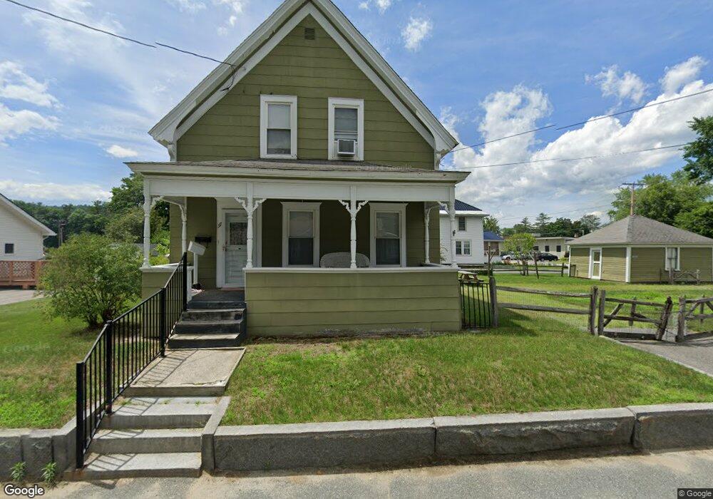
37 Smith St Haverhill, NH 03765
Estimated Value: $275,000 - $322,539
3
Beds
2
Baths
1,944
Sq Ft
$152/Sq Ft
Est. Value
About This Home
This home is located at 37 Smith St, Haverhill, NH 03765 and is currently estimated at $295,385, approximately $151 per square foot. 37 Smith St is a home with nearby schools including Woodsville Elementary School, Haverhill Cooperative Middle School, and Woodsville High School.
Ownership History
Date
Name
Owned For
Owner Type
Purchase Details
Closed on
Nov 22, 2019
Sold by
Bishop Etta May Est
Bought by
Mossi Teresa
Current Estimated Value
Purchase Details
Closed on
Jun 15, 2012
Sold by
Deming Randy L and Michael Rebecca J
Bought by
Bishop Etta M
Purchase Details
Closed on
May 16, 2008
Sold by
Preston & Sons N Country
Bought by
Deming Randy L
Home Financials for this Owner
Home Financials are based on the most recent Mortgage that was taken out on this home.
Original Mortgage
$120,000
Interest Rate
5.91%
Mortgage Type
Purchase Money Mortgage
Create a Home Valuation Report for This Property
The Home Valuation Report is an in-depth analysis detailing your home's value as well as a comparison with similar homes in the area
Home Values in the Area
Average Home Value in this Area
Purchase History
| Date | Buyer | Sale Price | Title Company |
|---|---|---|---|
| Mossi Teresa | $128,000 | -- | |
| Bishop Etta M | $127,500 | -- | |
| Deming Randy L | $155,000 | -- |
Source: Public Records
Mortgage History
| Date | Status | Borrower | Loan Amount |
|---|---|---|---|
| Previous Owner | Deming Randy L | $120,000 |
Source: Public Records
Tax History Compared to Growth
Tax History
| Year | Tax Paid | Tax Assessment Tax Assessment Total Assessment is a certain percentage of the fair market value that is determined by local assessors to be the total taxable value of land and additions on the property. | Land | Improvement |
|---|---|---|---|---|
| 2024 | $4,615 | $237,400 | $26,400 | $211,000 |
| 2023 | $3,653 | $126,300 | $6,900 | $119,400 |
| 2021 | $3,144 | $126,300 | $6,900 | $119,400 |
| 2020 | $2,875 | $101,200 | $6,900 | $94,300 |
| 2019 | $4,102 | $101,200 | $6,900 | $94,300 |
| 2018 | $2,833 | $101,200 | $6,900 | $94,300 |
| 2017 | $3,710 | $101,200 | $6,900 | $94,300 |
| 2016 | $3,012 | $101,200 | $6,900 | $94,300 |
| 2015 | $3,413 | $115,800 | $9,100 | $106,700 |
| 2014 | $3,183 | $115,800 | $9,100 | $106,700 |
| 2013 | $3,039 | $115,800 | $9,100 | $106,700 |
Source: Public Records
Map
Nearby Homes
- 11 Smith St
- 15 Trailer Park Rd
- 50 S Court St
- 6 Chapel St
- 95 Main St N
- 41-43 Central St
- 15 Harmony Dr
- 28 Boomhower Rd
- 68 Monroe Rd
- 41 Schaeffer Hill
- 67 Mount Gardner Rd
- 1118 Ryegate Rd
- 929-933 W Bath Rd
- 340 Whitelaw Rd
- 00 U S 302
- 882 Morse Rd
- 2849 Dartmouth College Hwy
- 2862 Dartmouth College Hwy
- 2819 Dartmouth College Hwy
- 2733 Dartmouth College Hwy