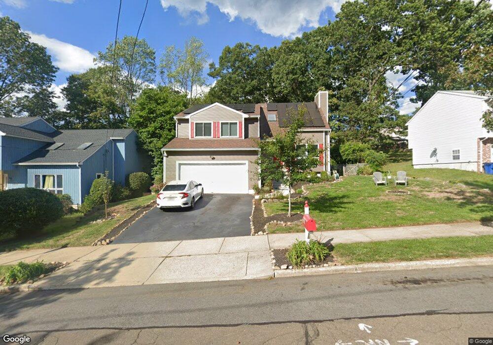
370 Stevenson Rd New Haven, CT 06515
Westville NeighborhoodEstimated Value: $440,000 - $556,000
4
Beds
3
Baths
2,228
Sq Ft
$230/Sq Ft
Est. Value
About This Home
This home is located at 370 Stevenson Rd, New Haven, CT 06515 and is currently estimated at $512,281, approximately $229 per square foot. 370 Stevenson Rd is a home located in New Haven County with nearby schools including Elm City Montessori School and Hopkins School.
Ownership History
Date
Name
Owned For
Owner Type
Purchase Details
Closed on
May 27, 2011
Sold by
Kearse Deborah L
Bought by
Bearse Douglas K
Current Estimated Value
Purchase Details
Closed on
Feb 12, 2009
Sold by
Alexander Melanie and Alexander Lawrence
Bought by
National City Bk
Home Financials for this Owner
Home Financials are based on the most recent Mortgage that was taken out on this home.
Original Mortgage
$234,842
Interest Rate
5.14%
Mortgage Type
VA
Purchase Details
Closed on
May 26, 2005
Sold by
Berglass Ahigall
Bought by
Alexander Lawrence and Alexander Melanie M
Purchase Details
Closed on
Apr 29, 2002
Sold by
Tambis Thomas A and Tambis Christine D
Bought by
Berglass Abigail
Purchase Details
Closed on
Jul 18, 1994
Sold by
Soskin Karen
Bought by
Tambis Thomas A and Tambis Christine D
Purchase Details
Closed on
Nov 1, 1991
Sold by
Stevenson Rd Inc
Bought by
Saskin Karen
Create a Home Valuation Report for This Property
The Home Valuation Report is an in-depth analysis detailing your home's value as well as a comparison with similar homes in the area
Home Values in the Area
Average Home Value in this Area
Purchase History
| Date | Buyer | Sale Price | Title Company |
|---|---|---|---|
| Bearse Douglas K | -- | -- | |
| National City Bk | -- | -- | |
| Alexander Lawrence | $345,000 | -- | |
| Berglass Abigail | $265,000 | -- | |
| Tambis Thomas A | $169,000 | -- | |
| Saskin Karen | $185,000 | -- |
Source: Public Records
Mortgage History
| Date | Status | Borrower | Loan Amount |
|---|---|---|---|
| Open | Saskin Karen | $227,582 | |
| Previous Owner | Saskin Karen | $234,842 |
Source: Public Records
Tax History Compared to Growth
Tax History
| Year | Tax Paid | Tax Assessment Tax Assessment Total Assessment is a certain percentage of the fair market value that is determined by local assessors to be the total taxable value of land and additions on the property. | Land | Improvement |
|---|---|---|---|---|
| 2025 | $9,256 | $234,920 | $65,310 | $169,610 |
| 2024 | $9,044 | $234,920 | $65,310 | $169,610 |
| 2023 | $8,739 | $234,920 | $65,310 | $169,610 |
| 2022 | $9,338 | $234,920 | $65,310 | $169,610 |
| 2021 | $8,140 | $185,500 | $42,420 | $143,080 |
| 2020 | $8,170 | $186,200 | $42,420 | $143,780 |
| 2019 | $8,003 | $186,200 | $42,420 | $143,780 |
| 2018 | $8,003 | $186,200 | $42,420 | $143,780 |
| 2017 | $7,202 | $186,200 | $42,420 | $143,780 |
| 2016 | $8,086 | $194,600 | $44,030 | $150,570 |
| 2015 | $8,086 | $194,600 | $44,030 | $150,570 |
| 2014 | $8,158 | $196,350 | $44,030 | $152,320 |
Source: Public Records
Map
Nearby Homes
- 690 Forest Rd Unit 702
- 690 Forest Rd Unit 392
- 690 Forest Rd Unit 511
- 699 Forest Rd
- 11 Priscilla Rd
- 1975 Chapel St
- 119 Westwood Rd
- 36 Birch Dr
- 36 Forest Hills Rd
- 119 Brooklawn Cir
- 55 Marvel Rd
- 56 Highview Ave
- 360 Fountain St Unit 5
- 126 Willard St
- 51 Fountain Terrace
- 206 W Rock Ave
- 595 Central Ave
- 1016 Whalley Ave Unit 6
- 846 Beechwood Rd
- 100 Yates St
- 360 Stevenson Rd
- 374 Stevenson Rd
- 400 Stevenson Rd
- 410 Stevenson Rd
- 390 Stevenson Rd
- 35 Spencer Place
- 25 Spencer Place
- 45 Spencer Place
- 375 Stevenson Rd
- 365 Stevenson Rd
- 420 Stevenson Rd
- 385 Stevenson Rd
- 355 Stevenson Rd
- 15 Spencer Place
- 430 Stevenson Rd
- 345 Stevenson Rd
- 395 Stevenson Rd
- 415 Stevenson Rd
- 435 Stevenson Rd
- 36 Spencer Place